Property Record
33 River Rd, Agawam, MA 01001
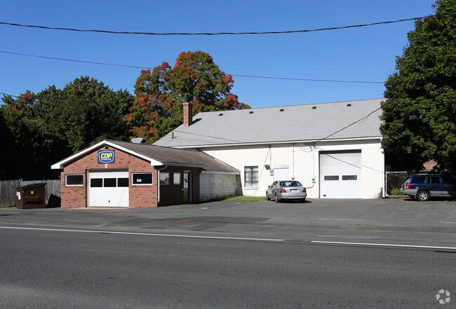


Property Detail
33 River Rd
AGAW-000004K-000002-000006
Hampden
Autorepair
Massachusetts
IA
6
B and X Area of moderate flood hazard, usually the area between the limits of the 100-year and 500-year floods.
0.74 AC
2025
Hampden County
2025
Hartford
813208
Springfield, MA
6,670 SF
NEARBY LISTINGS FOR SALE OR LEASE
DEMOGRAPHICS near 33 River Rd
1 mile
3 mile
5 mile
2025 Total Population
3,005
32,161
149,343
2030 Population
2,955
32,155
149,694
Pop Growth 2025-2030
(1.66%)
(0.02%)
+ 0.24%
Average Age
45
43
40
2025 Total Households
1,277
12,634
58,729
HH Growth 2025-2030
(1.80%)
(0.12%)
+ 0.26%
Median Household Inc
$80,357
$100,180
$64,580
Avg Household Size
2.30
2.40
2.40
2025 Avg HH Vehicles
2.00
2.00
2.00
Median Home Value
$328,670
$340,927
$308,387
Median Year Built
1970
1958
1955
Nearby Places
Map Layers
Map Styles
 Street
 Aerial
Layers
 Traffic
 Biking
Places
Listings with unknown addresses are not visible on the map
- Restaurants
- Banks
- Shops
- Fitness
- Groceries
PUBLIC TRANSPORTATION
COMMUTER RAIL
Drive
Walk
Distance
10 min
5.5 mi
Windsor Locks (Hartford Line - CT Rail (CTRail))
Drive
Walk
Distance
Windsor Locks (Hartford Line - CT Rail (CTRail))
19 min
9.6 mi
AIRPORT
Bradley International
Drive
Walk
Distance
Bradley International
25 min
9.7 mi
Nearby Properties
Address
Land Use
TOTAL SIZE
Lot Size
Zoning
Address
Land Use
TOTAL SIZE
Lot Size
Zoning
236,616 SF
31.07 AC
RA1
Address
Land Use
TOTAL SIZE
Lot Size
Zoning
36.53 AC
IB
Address
Land Use
TOTAL SIZE
Lot Size
Zoning
236,032 SF
41.65 AC
RA2
Address
Land Use
TOTAL SIZE
Lot Size
Zoning
8,712 SF
25.08 AC
RA1
Address
Land Use
TOTAL SIZE
Lot Size
Zoning
1,840 SF
148.78 AC
BB
Address
Land Use
TOTAL SIZE
Lot Size
Zoning
65.52 AC
BR
Address
Land Use
TOTAL SIZE
Lot Size
Zoning
18.51 AC
BA
Address
Land Use
TOTAL SIZE
Lot Size
Zoning
241,663 SF
13.59 AC
IA
Address
Land Use
TOTAL SIZE
Lot Size
Zoning
63,891 SF
3.50 AC
RA2
Address
Land Use
TOTAL SIZE
Lot Size
Zoning
78,732 SF
16.72 AC
BA
Address
Land Use
TOTAL SIZE
Lot Size
Zoning
73,356 SF
18.20 AC
RA2
Address
Land Use
TOTAL SIZE
Lot Size
Zoning
205,380 SF
15.41 AC
IA
Address
Land Use
TOTAL SIZE
Lot Size
Zoning
11.51 AC
RA1
Address
Land Use
TOTAL SIZE
Lot Size
Zoning
23,660 SF
9.28 AC
RA1
Address
Land Use
TOTAL SIZE
Lot Size
Zoning
91,735 SF
9.28 AC
RA1
Address
Land Use
TOTAL SIZE
Lot Size
Zoning
186,125 SF
14.69 AC
IA
Address
Land Use
TOTAL SIZE
Lot Size
Zoning
6.73 AC
BA
Address
Land Use
TOTAL SIZE
Lot Size
Zoning
5.14 AC
IA
Address
Land Use
TOTAL SIZE
Lot Size
Zoning
72,832 SF
10 AC
RA1
Address
Land Use
TOTAL SIZE
Lot Size
Zoning
16.74 AC
IA
Address
Land Use
TOTAL SIZE
Lot Size
Zoning
83,699 SF
16.05 AC
RA1
Address
Land Use
TOTAL SIZE
Lot Size
Zoning
97,410 SF
26.59 AC
IA
Address
Land Use
TOTAL SIZE
Lot Size
Zoning
125,000 SF
15.35 AC
IA
Address
Land Use
TOTAL SIZE
Lot Size
Zoning
12.26 AC
IB
Address
Land Use
TOTAL SIZE
Lot Size
Zoning
68,644 SF
5.20 AC
RA2
Address
Land Use
TOTAL SIZE
Lot Size
Zoning
220.65 AC
RA1
Address
Land Use
TOTAL SIZE
Lot Size
Zoning
62,471 SF
28.11 AC
RA2
Address
Land Use
TOTAL SIZE
Lot Size
Zoning
9.50 AC
RA2
Address
Land Use
TOTAL SIZE
Lot Size
Zoning
67,432 SF
12.60 AC
RA2
Address
Land Use
TOTAL SIZE
Lot Size
Zoning
146,211 SF
11.72 AC
IA
The World's #1 Commercial Real Estate Marketplace
Connect with us
© 2026 CoStar Group
The information above has been obtained from sources believed reliable. While we do not doubt its accuracy we have not verified it and make no guarantee, warranty or representation about it. It is your responsibility to independently confirm its accuracy and completeness. Any projections, opinions, assumptions, or estimates used are for example only and do not represent the current or future performance of the property. The value of this transaction to you depends on tax and other factors which should be evaluated by your tax, financial, and legal advisors. You and your advisors should conduct a careful, independent investigation of the property to determine to your satisfaction the suitability of the property for your needs.