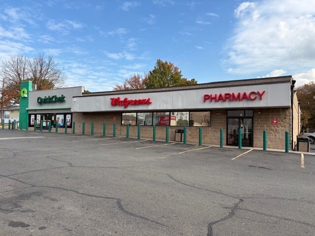
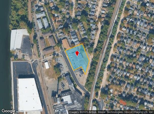
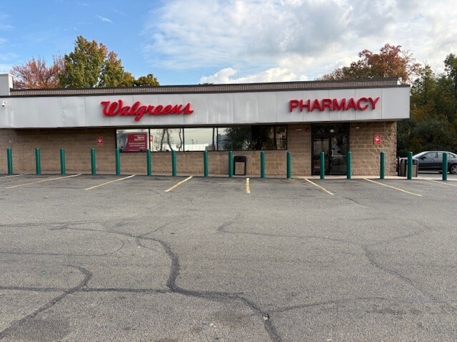
Property Record
21 River Rd, Bogota, NJ 07603
Current Lease Availabilities
NEARBY LISTINGS FOR SALE OR LEASE
Property Detail
21 River Rd
New York-Jersey City-White Plains, NY-NJ
1.28AC
04-00111-0000-00001-01
Bergen
Commercialnec
New Jersey
X
1.1
34003C0256H
1.28 AC
2024
Hackensack
2025
Northern New Jersey
004002
DEMOGRAPHICS near 21 River Rd
1 Mile
3 Mile
5 Mile
2024 Total Population
29,010
200,085
557,033
2029 Population
28,318
197,379
548,902
Pop Growth 2024-2029
(2.39%)
(1.35%)
(1.46%)
Average Age
41
41
41
2024 Total Households
9,938
75,579
208,206
HH Growth 2024-2029
(2.47%)
(1.33%)
(1.39%)
Median Household Inc
$81,346
$87,049
$89,038
Avg Household Size
2.70
2.50
2.60
2024 Avg HH Vehicles
2.00
2.00
2.00
Median Home Value
$399,211
$438,664
$468,920
Median Year Built
1951
1958
1958
Nearby Places
- Restaurants
- Banks
- Shops
- Fitness
- Groceries
PUBLIC TRANSPORTATION
COMMUTER RAIL
Essex Street (Pascack Valley Line - NJ Transit Commuter Rail (NJ Transit))
DRIVE
WALK
Distance
Essex Street (Pascack Valley Line - NJ Transit Commuter Rail (NJ Transit))
4 min
1.7 mi
Anderson Street (Pascack Valley Line - NJ Transit Commuter Rail (NJ Transit))
DRIVE
WALK
Distance
Anderson Street (Pascack Valley Line - NJ Transit Commuter Rail (NJ Transit))
5 min
2.1 mi
AIRPORT
LaGuardia
DRIVE
WALK
Distance
LaGuardia
28 min
15.7 mi
Newark Liberty International
DRIVE
WALK
Distance
Newark Liberty International
21 min
16.4 mi
John F Kennedy International
DRIVE
WALK
Distance
John F Kennedy International
40 min
26.8 mi
Freight Ports
Maher Terminal
DRIVE
WALK
Distance
Maher Terminal
29 min
18.5 mi
Nearby Properties
Address
Land Use
TOTAL SIZE
Lot Size
Zoning
Address
Land Use
TOTAL SIZE
Lot Size
Zoning
488,779 SF
7.55 AC
HCS
Address
Land Use
TOTAL SIZE
Lot Size
Zoning
335.71 AC
AF
Address
Land Use
TOTAL SIZE
Lot Size
Zoning
Address
Land Use
TOTAL SIZE
Lot Size
Zoning
Address
Land Use
TOTAL SIZE
Lot Size
Zoning
4.37 AC
HCS
Address
Land Use
TOTAL SIZE
Lot Size
Zoning
512,862 SF
14.16 AC
Address
Land Use
TOTAL SIZE
Lot Size
Zoning
281,720 SF
3.93 AC
R-3
Address
Land Use
TOTAL SIZE
Lot Size
Zoning
20.07 AC
H
Address
Land Use
TOTAL SIZE
Lot Size
Zoning
74,550 SF
11.28 AC
OI
Address
Land Use
TOTAL SIZE
Lot Size
Zoning
608,596 SF
27.10 AC
LID
Address
Land Use
TOTAL SIZE
Lot Size
Zoning
232,368 SF
5.10 AC
Address
Land Use
TOTAL SIZE
Lot Size
Zoning
30.46 AC
I
Address
Land Use
TOTAL SIZE
Lot Size
Zoning
25,620 SF
21.37 AC
Address
Land Use
TOTAL SIZE
Lot Size
Zoning
4.89 AC
R10
Address
Land Use
TOTAL SIZE
Lot Size
Zoning
4.54 AC
R-M3
Address
Land Use
TOTAL SIZE
Lot Size
Zoning
2.55 AC
RC-1
Address
Land Use
TOTAL SIZE
Lot Size
Zoning
261,303 SF
5.60 AC
O
Address
Land Use
TOTAL SIZE
Lot Size
Zoning
303,434 SF
13.34 AC
Address
Land Use
TOTAL SIZE
Lot Size
Zoning
Address
Land Use
TOTAL SIZE
Lot Size
Zoning
394,046 SF
1.88 AC
R3
Address
Land Use
TOTAL SIZE
Lot Size
Zoning
2,191 SF
1.34 AC
B2
Address
Land Use
TOTAL SIZE
Lot Size
Zoning
13 AC
B-3
Address
Land Use
TOTAL SIZE
Lot Size
Zoning
31,896 SF
1.64 AC
O
Address
Land Use
TOTAL SIZE
Lot Size
Zoning
2.92 AC
RC-2
Address
Land Use
TOTAL SIZE
Lot Size
Zoning
5.53 AC
RS
Address
Land Use
TOTAL SIZE
Lot Size
Zoning
340,218 SF
8.69 AC
B-3
Address
Land Use
TOTAL SIZE
Lot Size
Zoning
Address
Land Use
TOTAL SIZE
Lot Size
Zoning
431,600 SF
2.70 AC
R3
Address
Land Use
TOTAL SIZE
Lot Size
Zoning
1.22 AC
RC3
Address
Land Use
TOTAL SIZE
Lot Size
Zoning
431,600 SF
2.84 AC
R3
The World's #1 Commercial Real Estate Marketplace
Connect with us
© 2025 CoStar Group
The information above has been obtained from sources believed reliable. While we do not doubt its accuracy we have not verified it and make no guarantee, warranty or representation about it. It is your responsibility to independently confirm its accuracy and completeness. Any projections, opinions, assumptions, or estimates used are for example only and do not represent the current or future performance of the property. The value of this transaction to you depends on tax and other factors which should be evaluated by your tax, financial, and legal advisors. You and your advisors should conduct a careful, independent investigation of the property to determine to your satisfaction the suitability of the property for your needs.