Property Record
33 River St, Chagrin Falls, OH 44022


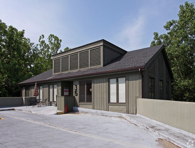
Property Detail
33 River St
932-06-045
20 S/L 153 ALL 0152 WP 93206046
Officebuilding
Cuyahoga
RB
Ohio
AE The base floodplain where base flood elevations are provided. AE Zones are now used on new format FIRMs instead of A1-A30 Zones.
152
2025
1 AC
2025
Southeast
195900
Cleveland
35,321 SF
Cleveland-Elyria, OH
NEARBY LISTINGS FOR SALE OR LEASE
DEMOGRAPHICS near 33 River St
1 mile
3 mile
5 mile
2025 Total Population
5,262
19,373
51,740
2030 Population
5,280
19,348
51,525
Pop Growth 2025-2030
+ 0.34%
(0.13%)
(0.42%)
Average Age
45
45
45
2025 Total Households
2,336
7,476
19,490
HH Growth 2025-2030
+ 0.26%
(0.12%)
(0.43%)
Median Household Inc
$102,391
$147,078
$142,674
Avg Household Size
2.20
2.50
2.60
2025 Avg HH Vehicles
2.00
2.00
2.00
Median Home Value
$436,277
$475,298
$451,686
Median Year Built
1957
1967
1972
Nearby Places
Map Layers
Map Styles
 Street
 Aerial
Layers
 Traffic
 Biking
Places
Listings with unknown addresses are not visible on the map
- Restaurants
- Banks
- Shops
- Fitness
- Groceries
PUBLIC TRANSPORTATION
AIRPORT
Cleveland-Hopkins International
Drive
Walk
Distance
Cleveland-Hopkins International
43 min
27.3 mi
Freight Ports
Port of Toledo
Drive
Walk
Distance
Port of Toledo
157 min
128.2 mi
SALE & LEASE HISTORY
LISTING DATE
SALE/LEASE

Jun 14, 2018
For Lease
Nearby Properties
Address
Land Use
TOTAL SIZE
Lot Size
Zoning
Address
Land Use
TOTAL SIZE
Lot Size
Zoning
7,531 SF
85.32 AC
R3A
Address
Land Use
TOTAL SIZE
Lot Size
Zoning
255.11 AC
U-1
Address
Land Use
TOTAL SIZE
Lot Size
Zoning
225,206 SF
55.30 AC
PI
Address
Land Use
TOTAL SIZE
Lot Size
Zoning
441.72 AC
1F-2
Address
Land Use
TOTAL SIZE
Lot Size
Zoning
176.15 AC
U1
Address
Land Use
TOTAL SIZE
Lot Size
Zoning
2,620 SF
15.81 AC
R5A
Address
Land Use
TOTAL SIZE
Lot Size
Zoning
42,274 SF
48.61 AC
U-1
Address
Land Use
TOTAL SIZE
Lot Size
Zoning
50,867 SF
212.96 AC
U-4
Address
Land Use
TOTAL SIZE
Lot Size
Zoning
93,610 SF
4.45 AC
RL
Address
Land Use
TOTAL SIZE
Lot Size
Zoning
77,296 SF
3.33 AC
RB
Address
Land Use
TOTAL SIZE
Lot Size
Zoning
67,861 SF
24.84 AC
R1A
Address
Land Use
TOTAL SIZE
Lot Size
Zoning
76.89 AC
U-1
Address
Land Use
TOTAL SIZE
Lot Size
Zoning
775 SF
124 AC
U-1
Address
Land Use
TOTAL SIZE
Lot Size
Zoning
86,896 SF
1.55 AC
PI
Address
Land Use
TOTAL SIZE
Lot Size
Zoning
58,075 SF
10.63 AC
PI
Address
Land Use
TOTAL SIZE
Lot Size
Zoning
7,510 SF
6.97 AC
U-1
Address
Land Use
TOTAL SIZE
Lot Size
Zoning
38,845 SF
8.84 AC
B3
Address
Land Use
TOTAL SIZE
Lot Size
Zoning
125,740 SF
33.72 AC
RL
Address
Land Use
TOTAL SIZE
Lot Size
Zoning
11,702 SF
10.14 AC
1F-2
Address
Land Use
TOTAL SIZE
Lot Size
Zoning
20,550 SF
8.21 AC
U-1
Address
Land Use
TOTAL SIZE
Lot Size
Zoning
36,827 SF
6.54 AC
R5A
Address
Land Use
TOTAL SIZE
Lot Size
Zoning
43,221 SF
14.17 AC
LIR
Address
Land Use
TOTAL SIZE
Lot Size
Zoning
36,733 SF
1.34 AC
U-1
Address
Land Use
TOTAL SIZE
Lot Size
Zoning
12,564 SF
1.59 AC
Address
Land Use
TOTAL SIZE
Lot Size
Zoning
46.33 AC
U-1
Address
Land Use
TOTAL SIZE
Lot Size
Zoning
6,100 SF
62.90 AC
1F-2
Address
Land Use
TOTAL SIZE
Lot Size
Zoning
34,354 SF
1.04 AC
PI
Address
Land Use
TOTAL SIZE
Lot Size
Zoning
2.37 AC
U-1
Address
Land Use
TOTAL SIZE
Lot Size
Zoning
56,518 SF
5.86 AC
RMF-10
Address
Land Use
TOTAL SIZE
Lot Size
Zoning
73.85 AC
C
The World's #1 Commercial Real Estate Marketplace
Connect with us
© 2026 CoStar Group
The information above has been obtained from sources believed reliable. While we do not doubt its accuracy we have not verified it and make no guarantee, warranty or representation about it. It is your responsibility to independently confirm its accuracy and completeness. Any projections, opinions, assumptions, or estimates used are for example only and do not represent the current or future performance of the property. The value of this transaction to you depends on tax and other factors which should be evaluated by your tax, financial, and legal advisors. You and your advisors should conduct a careful, independent investigation of the property to determine to your satisfaction the suitability of the property for your needs.