Property Record
33 Seanest Dr, Mashpee, MA 02649
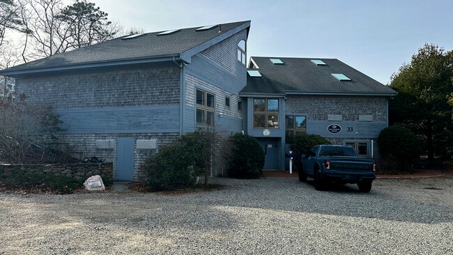

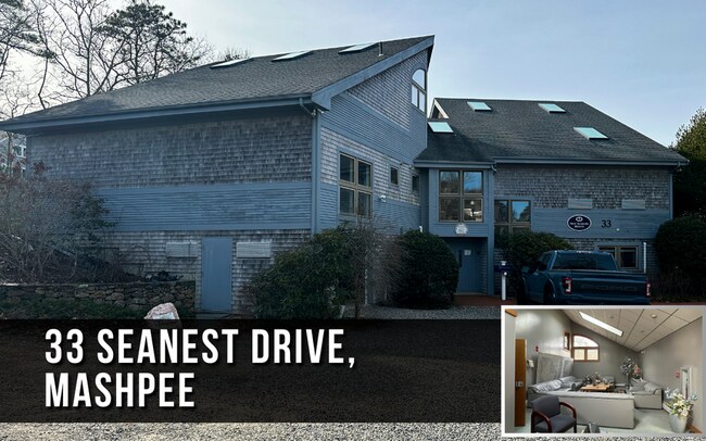
Property Detail
33 Seanest Dr
Governmentalpublicusegeneral
Barnstable
R3
Massachusetts
B and X Area of moderate flood hazard, usually the area between the limits of the 100-year and 500-year floods.
0.37 AC
2025
Cape Cod
2025
Other Market Areas
015200
Barnstable Town, MA
10,308 SF
MASH-000127-000108
NEARBY LISTINGS FOR SALE OR LEASE
-
-
View all Mashpee listings for sale on LoopNet.com
DEMOGRAPHICS near 33 Seanest Dr
1 mile
3 mile
5 mile
2025 Total Population
1,687
7,801
24,377
2030 Population
1,888
8,334
25,065
Pop Growth 2025-2030
+ 11.91%
+ 6.83%
+ 2.82%
Average Age
57
53
52
2025 Total Households
845
3,727
11,270
HH Growth 2025-2030
+ 11.83%
+ 6.87%
+ 2.74%
Median Household Inc
$131,944
$110,534
$96,901
Avg Household Size
2.00
2.10
2.10
2025 Avg HH Vehicles
2.00
2.00
2.00
Median Home Value
$886,937
$771,361
$687,025
Median Year Built
1985
1984
1982
Nearby Places
Map Layers
Map Styles
 Street
 Aerial
Layers
 Traffic
 Biking
Places
Listings with unknown addresses are not visible on the map
- Restaurants
- Banks
- Shops
- Fitness
- Groceries
PUBLIC TRANSPORTATION
AIRPORT
Martha's Vineyard
Drive
Walk
Distance
Martha's Vineyard
92 min
29.1 mi
Nantucket Memorial
Drive
Walk
Distance
Nantucket Memorial
180 min
49.9 mi
Freight Ports
Port of New Bedford Harbor
Drive
Walk
Distance
Port of New Bedford Harbor
70 min
46.2 mi
SALE & LEASE HISTORY
LISTING DATE
SALE/LEASE

Feb 22, 2024
For Sale
Nearby Properties
Address
Land Use
TOTAL SIZE
Lot Size
Zoning
Address
Land Use
TOTAL SIZE
Lot Size
Zoning
287 AC
R3
Address
Land Use
TOTAL SIZE
Lot Size
Zoning
333.20 AC
RA
Address
Land Use
TOTAL SIZE
Lot Size
Zoning
2,993 SF
67.60 AC
R3
Address
Land Use
TOTAL SIZE
Lot Size
Zoning
29,449 SF
45.06 AC
R3
Address
Land Use
TOTAL SIZE
Lot Size
Zoning
1.26 AC
R3
Address
Land Use
TOTAL SIZE
Lot Size
Zoning
6.26 AC
R3
Address
Land Use
TOTAL SIZE
Lot Size
Zoning
28.88 AC
R
Address
Land Use
TOTAL SIZE
Lot Size
Zoning
16.45 AC
R3
Address
Land Use
TOTAL SIZE
Lot Size
Zoning
35.80 AC
R3
Address
Land Use
TOTAL SIZE
Lot Size
Zoning
4,026 SF
0.64 AC
R3
Address
Land Use
TOTAL SIZE
Lot Size
Zoning
3,293 SF
0.52 AC
R3
Address
Land Use
TOTAL SIZE
Lot Size
Zoning
8,404 SF
1.56 AC
R3
Address
Land Use
TOTAL SIZE
Lot Size
Zoning
0.52 AC
R3
Address
Land Use
TOTAL SIZE
Lot Size
Zoning
4,768 SF
0.81 AC
R3
Address
Land Use
TOTAL SIZE
Lot Size
Zoning
0.85 AC
R3
Address
Land Use
TOTAL SIZE
Lot Size
Zoning
3,993 SF
0.79 AC
R3
Address
Land Use
TOTAL SIZE
Lot Size
Zoning
19.70 AC
Address
Land Use
TOTAL SIZE
Lot Size
Zoning
3.10 AC
R
Address
Land Use
TOTAL SIZE
Lot Size
Zoning
391 SF
26.83 AC
R3
Address
Land Use
TOTAL SIZE
Lot Size
Zoning
2,436 SF
0.42 AC
R3
Address
Land Use
TOTAL SIZE
Lot Size
Zoning
4,029 SF
0.55 AC
R3
Address
Land Use
TOTAL SIZE
Lot Size
Zoning
39 AC
R3
Address
Land Use
TOTAL SIZE
Lot Size
Zoning
73.40 AC
R3
Address
Land Use
TOTAL SIZE
Lot Size
Zoning
0.40 AC
R3
Address
Land Use
TOTAL SIZE
Lot Size
Zoning
1.15 AC
R3
Address
Land Use
TOTAL SIZE
Lot Size
Zoning
2,096 SF
2.81 AC
R3
Address
Land Use
TOTAL SIZE
Lot Size
Zoning
1,080 SF
3.16 AC
R3
Address
Land Use
TOTAL SIZE
Lot Size
Zoning
2,930 SF
0.43 AC
R3
Address
Land Use
TOTAL SIZE
Lot Size
Zoning
2.01 AC
R3
Address
Land Use
TOTAL SIZE
Lot Size
Zoning
2.49 AC
R3
The World's #1 Commercial Real Estate Marketplace
Connect with us
© 2026 CoStar Group
The information above has been obtained from sources believed reliable. While we do not doubt its accuracy we have not verified it and make no guarantee, warranty or representation about it. It is your responsibility to independently confirm its accuracy and completeness. Any projections, opinions, assumptions, or estimates used are for example only and do not represent the current or future performance of the property. The value of this transaction to you depends on tax and other factors which should be evaluated by your tax, financial, and legal advisors. You and your advisors should conduct a careful, independent investigation of the property to determine to your satisfaction the suitability of the property for your needs.