Property Record
33 Skytop Rd, Long Valley, NJ 07853
Current Lease Availabilities
NEARBY LISTINGS FOR SALE OR LEASE
-
-
View all Long Valley listings for lease on LoopNet.com
Property Detail
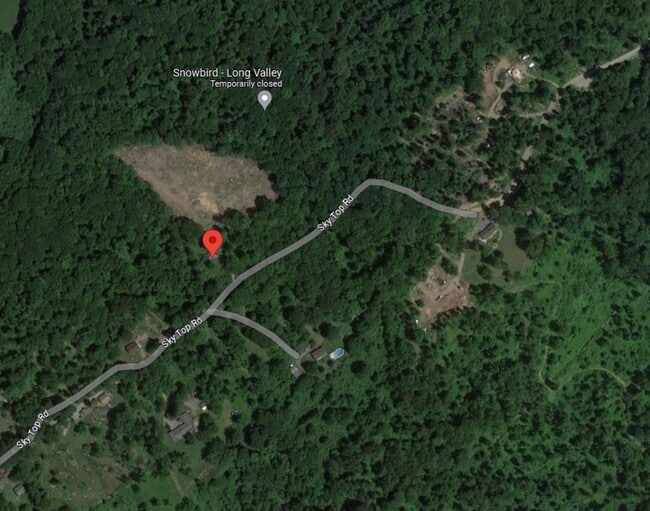
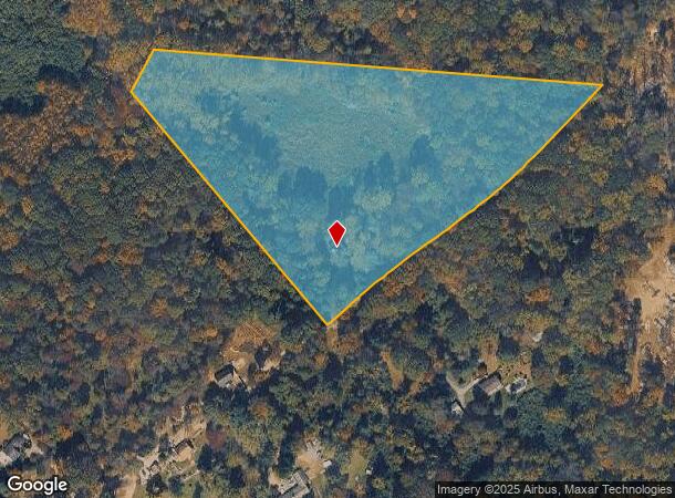
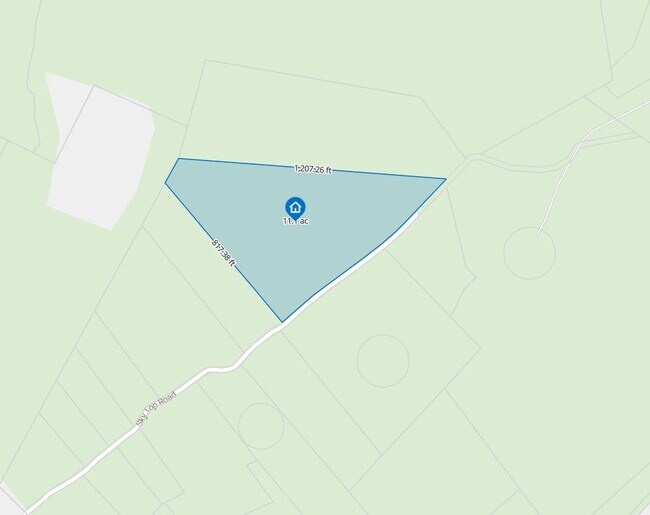
33 Skytop Rd
Northern New Jersey
Morris
Newark, NJ
New Jersey
38-00052-0000-00008
11.20 AC
Sfr
Western Morris
1,774 SF
DEMOGRAPHICS near 33 Skytop Rd
1 Mile
3 Mile
5 Mile
2024 Total Population
342
7,340
23,392
2029 Population
339
7,298
23,414
Pop Growth 2024-2029
(0.88%)
(0.57%)
+ 0.09%
Average Age
43
43
44
2024 Total Households
120
2,621
8,420
HH Growth 2024-2029
(0.83%)
(0.53%)
+ 0.14%
Median Household Inc
$161,111
$150,409
$138,222
Avg Household Size
2.80
2.80
2.70
2024 Avg HH Vehicles
3.00
2.00
2.00
Median Home Value
$630,435
$544,178
$476,729
Median Year Built
1980
1974
1975
Nearby Places
Map Layers
Map Styles
 Street
 Aerial
- Restaurants
- Banks
- Shops
- Fitness
- Groceries
PUBLIC TRANSPORTATION
COMMUTER RAIL
High Bridge (Raritan Valley Line - NJ Transit Commuter Rail (NJ Transit))
DRIVE
WALK
Distance
High Bridge (Raritan Valley Line - NJ Transit Commuter Rail (NJ Transit))
20 min
8.9 mi
Hackettstown (Montclair-Boonton Line - NJ Transit Commuter Rail (NJ Transit), Morris & Essex Morristown Line - NJ Transit Commuter Rail (NJ Transit))
DRIVE
WALK
Distance
Hackettstown (Montclair-Boonton Line - NJ Transit Commuter Rail (NJ Transit), Morris & Essex Morristown Line - NJ Transit Commuter Rail (NJ Transit))
22 min
9.2 mi
AIRPORT
Lehigh Valley International
DRIVE
WALK
Distance
Lehigh Valley International
70 min
37.1 mi
Trenton Mercer
DRIVE
WALK
Distance
Trenton Mercer
69 min
41.8 mi
Newark Liberty International
DRIVE
WALK
Distance
Newark Liberty International
71 min
45.8 mi
Freight Ports
Maher Terminal
DRIVE
WALK
Distance
Maher Terminal
76 min
46.4 mi
Nearby Properties
Address
Land Use
TOTAL SIZE
Lot Size
Zoning
Address
Land Use
TOTAL SIZE
Lot Size
Zoning
26.52 AC
RC
Address
Land Use
TOTAL SIZE
Lot Size
Zoning
3,823 SF
165 AC
RC
Address
Land Use
TOTAL SIZE
Lot Size
Zoning
5.70 AC
R-5
Address
Land Use
TOTAL SIZE
Lot Size
Zoning
10 AC
R-5
Address
Land Use
TOTAL SIZE
Lot Size
Zoning
26,281 SF
105 AC
RC
Address
Land Use
TOTAL SIZE
Lot Size
Zoning
64.75 AC
R-5
Address
Land Use
TOTAL SIZE
Lot Size
Zoning
66.80 AC
RC
Address
Land Use
TOTAL SIZE
Lot Size
Zoning
19,905 SF
1.92 AC
R-3
Address
Land Use
TOTAL SIZE
Lot Size
Zoning
53.35 AC
R-5
Address
Land Use
TOTAL SIZE
Lot Size
Zoning
32,049 SF
3.99 AC
B1
Address
Land Use
TOTAL SIZE
Lot Size
Zoning
3,102 SF
3 AC
R-5
Address
Land Use
TOTAL SIZE
Lot Size
Zoning
44,502 SF
16.86 AC
I
Address
Land Use
TOTAL SIZE
Lot Size
Zoning
28,530 SF
3.09 AC
HB
Address
Land Use
TOTAL SIZE
Lot Size
Zoning
750 SF
250.02 AC
RC
Address
Land Use
TOTAL SIZE
Lot Size
Zoning
12,737 SF
4.29 AC
HL
Address
Land Use
TOTAL SIZE
Lot Size
Zoning
2,738 SF
2.13 AC
HB
Address
Land Use
TOTAL SIZE
Lot Size
Zoning
8,439 SF
2 AC
R-5
Address
Land Use
TOTAL SIZE
Lot Size
Zoning
13,224 SF
2.45 AC
R-3
Address
Land Use
TOTAL SIZE
Lot Size
Zoning
Address
Land Use
TOTAL SIZE
Lot Size
Zoning
4,198 SF
25 AC
R-5
Address
Land Use
TOTAL SIZE
Lot Size
Zoning
8,430 SF
37.17 AC
R-5
Address
Land Use
TOTAL SIZE
Lot Size
Zoning
4,854 SF
2 AC
R-5
Address
Land Use
TOTAL SIZE
Lot Size
Zoning
15,940 SF
0.56 AC
GB
Address
Land Use
TOTAL SIZE
Lot Size
Zoning
6,084 SF
0.95 AC
R-3
Address
Land Use
TOTAL SIZE
Lot Size
Zoning
9,871 SF
2 AC
HL
Address
Land Use
TOTAL SIZE
Lot Size
Zoning
4,756 SF
1 AC
I
Address
Land Use
TOTAL SIZE
Lot Size
Zoning
3,515 SF
1 AC
HL
Address
Land Use
TOTAL SIZE
Lot Size
Zoning
5,787 SF
2.50 AC
RC
Address
Land Use
TOTAL SIZE
Lot Size
Zoning
11,820 SF
1.50 AC
B1
Address
Land Use
TOTAL SIZE
Lot Size
Zoning
7,632 SF
6 AC
R-3
The World's #1 Commercial Real Estate Marketplace
Connect with us
© 2026 CoStar Group
The information above has been obtained from sources believed reliable. While we do not doubt its accuracy we have not verified it and make no guarantee, warranty or representation about it. It is your responsibility to independently confirm its accuracy and completeness. Any projections, opinions, assumptions, or estimates used are for example only and do not represent the current or future performance of the property. The value of this transaction to you depends on tax and other factors which should be evaluated by your tax, financial, and legal advisors. You and your advisors should conduct a careful, independent investigation of the property to determine to your satisfaction the suitability of the property for your needs.