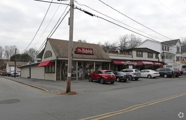
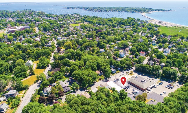
Property Record
33 Smith St, Marblehead, MA 01945

Current Lease Availabilities
Property Detail
33 Smith St
Commercialofficeresidentialmixeduse
Essex
B
Massachusetts
B and X Area of moderate flood hazard, usually the area between the limits of the 100-year and 500-year floods.
0.57 AC
2025
Peabody/Salem
2025
Boston
203100
Boston-Cambridge-Newton, MA-NH
17,090 SF
MARB-000070-000001
NEARBY LISTINGS FOR SALE OR LEASE
DEMOGRAPHICS near 33 Smith St
1 mile
3 mile
5 mile
2025 Total Population
12,292
70,437
196,368
2030 Population
12,683
72,216
199,870
Pop Growth 2025-2030
+ 3.18%
+ 2.53%
+ 1.78%
Average Age
44
42
41
2025 Total Households
4,780
29,646
78,363
HH Growth 2025-2030
+ 3.14%
+ 2.41%
+ 1.81%
Median Household Inc
$169,739
$109,712
$86,557
Avg Household Size
2.50
2.30
2.40
2025 Avg HH Vehicles
2.00
2.00
2.00
Median Home Value
$901,069
$740,921
$666,201
Median Year Built
1948
1949
1949
Nearby Places
Map Layers
Map Styles
 Street
 Aerial
Transit
 Traffic
 Biking
Places
Listings with unknown addresses are not visible on the map
- Restaurants
- Banks
- Shops
- Fitness
- Groceries
PUBLIC TRANSPORTATION
COMMUTER RAIL
Swampscott (Newburyport/Rockport Line - Massachusetts Bay Transportation Authority Commuter Rail (Purple Line))
Drive
Walk
Distance
Swampscott (Newburyport/Rockport Line - Massachusetts Bay Transportation Authority Commuter Rail (Purple Line))
7 min
3.5 mi
Salem (Newburyport/Rockport Line - Massachusetts Bay Transportation Authority Commuter Rail (Purple Line))
Drive
Walk
Distance
Salem (Newburyport/Rockport Line - Massachusetts Bay Transportation Authority Commuter Rail (Purple Line))
8 min
3.7 mi
AIRPORT
General Edward Lawrence Logan International
Drive
Walk
Distance
General Edward Lawrence Logan International
25 min
14.2 mi
Freight Ports
Port of Boston
Drive
Walk
Distance
Port of Boston
31 min
16.9 mi
Nearby Properties
Address
Land Use
TOTAL SIZE
Lot Size
Zoning
Address
Land Use
TOTAL SIZE
Lot Size
Zoning
14.69 AC
I
Address
Land Use
TOTAL SIZE
Lot Size
Zoning
9,860 SF
17.80 AC
R1
Address
Land Use
TOTAL SIZE
Lot Size
Zoning
192,341 SF
2.10 AC
B5
Address
Land Use
TOTAL SIZE
Lot Size
Zoning
29.12 AC
I
Address
Land Use
TOTAL SIZE
Lot Size
Zoning
154,524 SF
5.90 AC
B3
Address
Land Use
TOTAL SIZE
Lot Size
Zoning
190,000 SF
24.42 AC
N/A
Address
Land Use
TOTAL SIZE
Lot Size
Zoning
153,855 SF
6.08 AC
A-2
Address
Land Use
TOTAL SIZE
Lot Size
Zoning
38,440 SF
8.95 AC
I
Address
Land Use
TOTAL SIZE
Lot Size
Zoning
223,689 SF
11.60 AC
R1
Address
Land Use
TOTAL SIZE
Lot Size
Zoning
205,353 SF
18.74 AC
Address
Land Use
TOTAL SIZE
Lot Size
Zoning
4.14 AC
NRCC
Address
Land Use
TOTAL SIZE
Lot Size
Zoning
9.58 AC
R3
Address
Land Use
TOTAL SIZE
Lot Size
Zoning
14.50 AC
R1
Address
Land Use
TOTAL SIZE
Lot Size
Zoning
123,588 SF
1.50 AC
B5
Address
Land Use
TOTAL SIZE
Lot Size
Zoning
125,862 SF
5.30 AC
R1
Address
Land Use
TOTAL SIZE
Lot Size
Zoning
77,392 SF
6.82 AC
B3
Address
Land Use
TOTAL SIZE
Lot Size
Zoning
5 AC
B2
Address
Land Use
TOTAL SIZE
Lot Size
Zoning
80,069 SF
3.13 AC
A-2
Address
Land Use
TOTAL SIZE
Lot Size
Zoning
229,416 SF
14.81 AC
N/A
Address
Land Use
TOTAL SIZE
Lot Size
Zoning
7.28 AC
R3
Address
Land Use
TOTAL SIZE
Lot Size
Zoning
40,939 SF
12.48 AC
Address
Land Use
TOTAL SIZE
Lot Size
Zoning
19.52 AC
R3
Address
Land Use
TOTAL SIZE
Lot Size
Zoning
22.35 AC
R1
Address
Land Use
TOTAL SIZE
Lot Size
Zoning
42.30 AC
I
Address
Land Use
TOTAL SIZE
Lot Size
Zoning
13.26 AC
B2
Address
Land Use
TOTAL SIZE
Lot Size
Zoning
31.90 AC
I
Address
Land Use
TOTAL SIZE
Lot Size
Zoning
13.96 AC
B2
Address
Land Use
TOTAL SIZE
Lot Size
Zoning
90,004 SF
3.46 AC
R3
Address
Land Use
TOTAL SIZE
Lot Size
Zoning
91,968 SF
2.20 AC
R1
Address
Land Use
TOTAL SIZE
Lot Size
Zoning
123,936 SF
2.50 AC
B5
The World's #1 Commercial Real Estate Marketplace
Connect with us
© 2026 CoStar Group
The information above has been obtained from sources believed reliable. While we do not doubt its accuracy we have not verified it and make no guarantee, warranty or representation about it. It is your responsibility to independently confirm its accuracy and completeness. Any projections, opinions, assumptions, or estimates used are for example only and do not represent the current or future performance of the property. The value of this transaction to you depends on tax and other factors which should be evaluated by your tax, financial, and legal advisors. You and your advisors should conduct a careful, independent investigation of the property to determine to your satisfaction the suitability of the property for your needs.