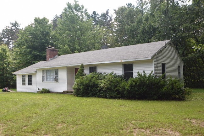
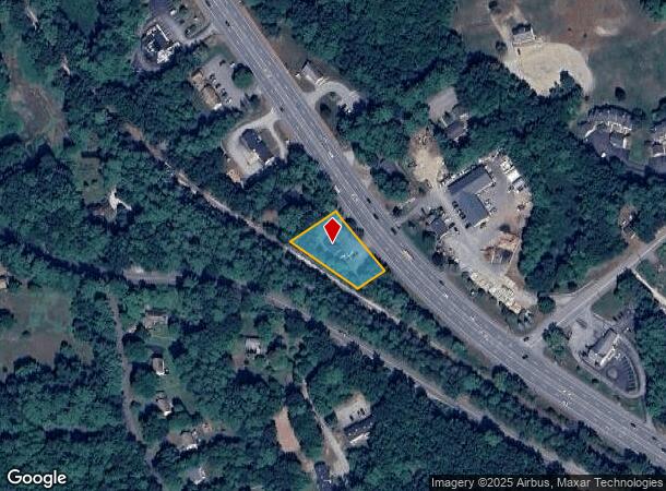
Property Record
33 State Route 101A, Amherst, NH 03031

NEARBY LISTINGS FOR SALE OR LEASE
Property Detail
33 State Route 101A
Manchester-Nashua, NH
Hillsborough
AMHS-000002-000103
New Hampshire
Sfr
0.44 AC
X
Hillsborough
33011C0478D
Boston
1,406 SF
DEMOGRAPHICS near 33 State Route 101A
1 Mile
3 Mile
5 Mile
2024 Total Population
1,162
17,186
41,456
2029 Population
1,177
17,512
42,518
Pop Growth 2024-2029
+ 1.29%
+ 1.90%
+ 2.56%
Average Age
44
42
42
2024 Total Households
453
6,914
16,259
HH Growth 2024-2029
+ 1.32%
+ 1.88%
+ 2.61%
Median Household Inc
$142,646
$105,032
$114,844
Avg Household Size
2.60
2.40
2.50
2024 Avg HH Vehicles
2.00
2.00
2.00
Median Home Value
$410,112
$411,050
$410,901
Median Year Built
1979
1980
1982
Nearby Places
Map Layers
Map Styles
 Street
 Aerial
- Restaurants
- Banks
- Shops
- Fitness
- Groceries
PUBLIC TRANSPORTATION
AIRPORT
Manchester Boston Regional
DRIVE
WALK
Distance
Manchester Boston Regional
28 min
15.5 mi
Freight Ports
Port of Boston
DRIVE
WALK
Distance
Port of Boston
76 min
50.2 mi
SALE & LEASE HISTORY
LISTING DATE
SALE/LEASE

Nov 02, 2018
For Sale
Jan 29, 2019
For Lease
Nearby Properties
Address
Land Use
TOTAL SIZE
Lot Size
Zoning
Address
Land Use
TOTAL SIZE
Lot Size
Zoning
259,644 SF
42.18 AC
RR
Address
Land Use
TOTAL SIZE
Lot Size
Zoning
360,491 SF
40.23 AC
IND
Address
Land Use
TOTAL SIZE
Lot Size
Zoning
200,012 SF
31.83 AC
C
Address
Land Use
TOTAL SIZE
Lot Size
Zoning
29,952 SF
12.50 AC
B
Address
Land Use
TOTAL SIZE
Lot Size
Zoning
102,843 SF
26.32 AC
A
Address
Land Use
TOTAL SIZE
Lot Size
Zoning
19,968 SF
5.91 AC
B
Address
Land Use
TOTAL SIZE
Lot Size
Zoning
15,616 SF
6.06 AC
B
Address
Land Use
TOTAL SIZE
Lot Size
Zoning
132,637 SF
14.16 AC
C
Address
Land Use
TOTAL SIZE
Lot Size
Zoning
64,589 SF
26.11 AC
RR11
Address
Land Use
TOTAL SIZE
Lot Size
Zoning
181,590 SF
12.79 AC
ICI
Address
Land Use
TOTAL SIZE
Lot Size
Zoning
131,191 SF
51.10 AC
C2- GE
Address
Land Use
TOTAL SIZE
Lot Size
Zoning
110,892 SF
18.38 AC
C2- GE
Address
Land Use
TOTAL SIZE
Lot Size
Zoning
72,384 SF
6.26 AC
A
Address
Land Use
TOTAL SIZE
Lot Size
Zoning
21,490 SF
10 AC
C
Address
Land Use
TOTAL SIZE
Lot Size
Zoning
70,612 SF
6.42 AC
C
Address
Land Use
TOTAL SIZE
Lot Size
Zoning
4.19 AC
IND
Address
Land Use
TOTAL SIZE
Lot Size
Zoning
66,088 SF
12.48 AC
ICI
Address
Land Use
TOTAL SIZE
Lot Size
Zoning
91,234 SF
8.92 AC
C
Address
Land Use
TOTAL SIZE
Lot Size
Zoning
23,040 SF
4.57 AC
LC
Address
Land Use
TOTAL SIZE
Lot Size
Zoning
54,186 SF
6.38 AC
Address
Land Use
TOTAL SIZE
Lot Size
Zoning
134,055 SF
8.93 AC
IND
Address
Land Use
TOTAL SIZE
Lot Size
Zoning
4,308 SF
4.75 AC
A
Address
Land Use
TOTAL SIZE
Lot Size
Zoning
50,003 SF
1.19 AC
C
Address
Land Use
TOTAL SIZE
Lot Size
Zoning
107,374 SF
7.15 AC
IND
Address
Land Use
TOTAL SIZE
Lot Size
Zoning
13,714 SF
4.54 AC
A
Address
Land Use
TOTAL SIZE
Lot Size
Zoning
24,630 SF
8.36 AC
C
Address
Land Use
TOTAL SIZE
Lot Size
Zoning
110,713 SF
31.41 AC
C
Address
Land Use
TOTAL SIZE
Lot Size
Zoning
43,572 SF
1.35 AC
C
Address
Land Use
TOTAL SIZE
Lot Size
Zoning
42,850 SF
11.23 AC
RR
Address
Land Use
TOTAL SIZE
Lot Size
Zoning
92,600 SF
6.22 AC
IND
The World's #1 Commercial Real Estate Marketplace
Connect with us
© 2025 CoStar Group
The information above has been obtained from sources believed reliable. While we do not doubt its accuracy we have not verified it and make no guarantee, warranty or representation about it. It is your responsibility to independently confirm its accuracy and completeness. Any projections, opinions, assumptions, or estimates used are for example only and do not represent the current or future performance of the property. The value of this transaction to you depends on tax and other factors which should be evaluated by your tax, financial, and legal advisors. You and your advisors should conduct a careful, independent investigation of the property to determine to your satisfaction the suitability of the property for your needs.