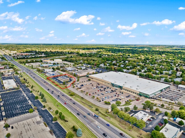
Property Record
330 N Randall Rd, Batavia, IL 60510


NEARBY LISTINGS FOR SALE OR LEASE
Property Detail
330 N Randall Rd
Chicago-Naperville-Elgin, IL-IN-WI
Batavia Land Company Sub No 1
12-16-351-008
BATAVIA LAND COMPANY SUB NO. 1 - LOT 2
Commercialnec
Kane
X
Illinois
17089C0327H
2
2024
1.47 AC
2024
Western East/West Corr
852700
Chicago
6,000 SF
DEMOGRAPHICS near 330 N Randall Rd
1 Mile
3 Mile
5 Mile
2024 Total Population
7,129
49,172
111,097
2029 Population
7,074
49,004
110,534
Pop Growth 2024-2029
(0.77%)
(0.34%)
(0.51%)
Average Age
43
42
41
2024 Total Households
2,807
18,502
41,769
HH Growth 2024-2029
(0.93%)
(0.37%)
(0.48%)
Median Household Inc
$119,234
$127,357
$114,208
Avg Household Size
2.50
2.60
2.60
2024 Avg HH Vehicles
2.00
2.00
2.00
Median Home Value
$368,780
$370,596
$342,054
Median Year Built
1991
1989
1989
Nearby Places
Map Layers
Map Styles
 Street
 Aerial
- Restaurants
- Banks
- Shops
- Fitness
- Groceries
PUBLIC TRANSPORTATION
COMMUTER RAIL
Geneva Station (Union Pacific West Line - Northeast Illinois Regional Commuter Railroad (Metra))
DRIVE
WALK
Distance
Geneva Station (Union Pacific West Line - Northeast Illinois Regional Commuter Railroad (Metra))
8 min
3.2 mi
La Fox Station (Union Pacific West Line - Northeast Illinois Regional Commuter Railroad (Metra))
DRIVE
WALK
Distance
La Fox Station (Union Pacific West Line - Northeast Illinois Regional Commuter Railroad (Metra))
13 min
6.1 mi
AIRPORT
Chicago O'Hare International
DRIVE
WALK
Distance
Chicago O'Hare International
57 min
34.1 mi
Chicago Midway International
DRIVE
WALK
Distance
Chicago Midway International
62 min
40.4 mi
SALE & LEASE HISTORY
LISTING DATE
SALE/LEASE

Mar 25, 2025
For Sale
Nearby Properties
Address
Land Use
TOTAL SIZE
Lot Size
Zoning
Address
Land Use
TOTAL SIZE
Lot Size
Zoning
404,578 SF
40.29 AC
Address
Land Use
TOTAL SIZE
Lot Size
Zoning
Address
Land Use
TOTAL SIZE
Lot Size
Zoning
217,340 SF
15.58 AC
Address
Land Use
TOTAL SIZE
Lot Size
Zoning
Address
Land Use
TOTAL SIZE
Lot Size
Zoning
Address
Land Use
TOTAL SIZE
Lot Size
Zoning
86,704 SF
0.53 AC
Address
Land Use
TOTAL SIZE
Lot Size
Zoning
33.78 AC
Address
Land Use
TOTAL SIZE
Lot Size
Zoning
170,986 SF
15.25 AC
Address
Land Use
TOTAL SIZE
Lot Size
Zoning
494,108 SF
5 AC
Address
Land Use
TOTAL SIZE
Lot Size
Zoning
136,208 SF
12.52 AC
Address
Land Use
TOTAL SIZE
Lot Size
Zoning
74,929 SF
6.08 AC
Address
Land Use
TOTAL SIZE
Lot Size
Zoning
Address
Land Use
TOTAL SIZE
Lot Size
Zoning
141,703 SF
15.94 AC
Address
Land Use
TOTAL SIZE
Lot Size
Zoning
5.26 AC
Address
Land Use
TOTAL SIZE
Lot Size
Zoning
258,390 SF
15.58 AC
Address
Land Use
TOTAL SIZE
Lot Size
Zoning
86,976 SF
8.15 AC
Address
Land Use
TOTAL SIZE
Lot Size
Zoning
33,761 SF
2.82 AC
Address
Land Use
TOTAL SIZE
Lot Size
Zoning
129,800 SF
11 AC
Address
Land Use
TOTAL SIZE
Lot Size
Zoning
309,756 SF
2.93 AC
Address
Land Use
TOTAL SIZE
Lot Size
Zoning
304,337 SF
15.34 AC
Address
Land Use
TOTAL SIZE
Lot Size
Zoning
Address
Land Use
TOTAL SIZE
Lot Size
Zoning
179,645 SF
7.10 AC
Address
Land Use
TOTAL SIZE
Lot Size
Zoning
199,317 SF
10.60 AC
Address
Land Use
TOTAL SIZE
Lot Size
Zoning
3.53 AC
Address
Land Use
TOTAL SIZE
Lot Size
Zoning
514,662 SF
19.75 AC
Address
Land Use
TOTAL SIZE
Lot Size
Zoning
260,812 SF
6.24 AC
Address
Land Use
TOTAL SIZE
Lot Size
Zoning
153,432 SF
7.16 AC
Address
Land Use
TOTAL SIZE
Lot Size
Zoning
212,720 SF
10.24 AC
Address
Land Use
TOTAL SIZE
Lot Size
Zoning
67,269 SF
7.50 AC
Address
Land Use
TOTAL SIZE
Lot Size
Zoning
138,862 SF
12.14 AC
The World's #1 Commercial Real Estate Marketplace
Connect with us
© 2025 CoStar Group
The information above has been obtained from sources believed reliable. While we do not doubt its accuracy we have not verified it and make no guarantee, warranty or representation about it. It is your responsibility to independently confirm its accuracy and completeness. Any projections, opinions, assumptions, or estimates used are for example only and do not represent the current or future performance of the property. The value of this transaction to you depends on tax and other factors which should be evaluated by your tax, financial, and legal advisors. You and your advisors should conduct a careful, independent investigation of the property to determine to your satisfaction the suitability of the property for your needs.