Property Record
330 Amherst St, Winchester, VA 22601
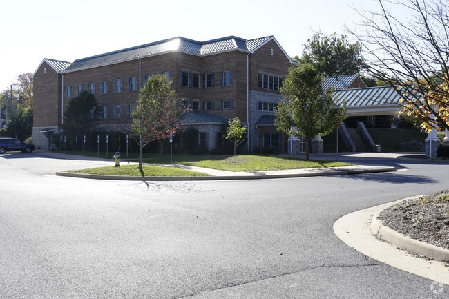


Property Detail
330 Amherst St
172-01-F-15-C
STEELE'S GARDENS ET AL BLA E S 104-120 SELMA DRIVE
Officebuilding
Winchester City
B1
Virginia
AE The base floodplain where base flood elevations are provided. AE Zones are now used on new format FIRMs instead of A1-A30 Zones.
4.05 AC
2025
Winchester City
2026
Washington, DC
000202
Winchester, VA-WV
15,295 SF
NEARBY LISTINGS FOR SALE OR LEASE
DEMOGRAPHICS near 330 Amherst St
1 mile
3 mile
5 mile
2025 Total Population
10,435
46,421
71,303
2030 Population
10,362
47,020
73,322
Pop Growth 2025-2030
(0.70%)
+ 1.29%
+ 2.83%
Average Age
40
40
40
2025 Total Households
4,437
18,079
27,074
HH Growth 2025-2030
(0.65%)
+ 1.14%
+ 2.66%
Median Household Inc
$63,268
$70,399
$77,640
Avg Household Size
2.20
2.40
2.50
2025 Avg HH Vehicles
2.00
2.00
2.00
Median Home Value
$414,216
$340,005
$372,279
Median Year Built
1952
1981
1986
Nearby Places
Map Layers
Map Styles
 Street
 Aerial
Layers
 Traffic
 Biking
Places
Listings with unknown addresses are not visible on the map
- Restaurants
- Banks
- Shops
- Fitness
- Groceries
Nearby Properties
Address
Land Use
TOTAL SIZE
Lot Size
Zoning
Address
Land Use
TOTAL SIZE
Lot Size
Zoning
979,509 SF
161.49 AC
MC
Address
Land Use
TOTAL SIZE
Lot Size
Zoning
90,399 SF
131.06 AC
MS
Address
Land Use
TOTAL SIZE
Lot Size
Zoning
64.27 AC
M1
Address
Land Use
TOTAL SIZE
Lot Size
Zoning
31,710 SF
47.28 AC
HE1
Address
Land Use
TOTAL SIZE
Lot Size
Zoning
47,089 SF
16.84 AC
LR
Address
Land Use
TOTAL SIZE
Lot Size
Zoning
10,821 SF
68.86 AC
RA
Address
Land Use
TOTAL SIZE
Lot Size
Zoning
40,820 SF
31.78 AC
M1
Address
Land Use
TOTAL SIZE
Lot Size
Zoning
465,856 SF
43.50 AC
M1
Address
Land Use
TOTAL SIZE
Lot Size
Zoning
94,606 SF
4.92 AC
B2
Address
Land Use
TOTAL SIZE
Lot Size
Zoning
33,264 SF
10.59 AC
MR
Address
Land Use
TOTAL SIZE
Lot Size
Zoning
331,925 SF
21.17 AC
M1
Address
Land Use
TOTAL SIZE
Lot Size
Zoning
191,138 SF
35 AC
EIP
Address
Land Use
TOTAL SIZE
Lot Size
Zoning
11,979 SF
10.82 AC
HR
Address
Land Use
TOTAL SIZE
Lot Size
Zoning
462,500 SF
53.51 AC
B2
Address
Land Use
TOTAL SIZE
Lot Size
Zoning
423,360 SF
24.23 AC
M1
Address
Land Use
TOTAL SIZE
Lot Size
Zoning
27,464 SF
8.53 AC
B2
Address
Land Use
TOTAL SIZE
Lot Size
Zoning
231,756 SF
23.66 AC
CM1
Address
Land Use
TOTAL SIZE
Lot Size
Zoning
325,000 SF
18.09 AC
M1
Address
Land Use
TOTAL SIZE
Lot Size
Zoning
151,711 SF
16.25 AC
CM1
Address
Land Use
TOTAL SIZE
Lot Size
Zoning
181,832 SF
17.96 AC
CM1
Address
Land Use
TOTAL SIZE
Lot Size
Zoning
65,320 SF
2.62 AC
B1
Address
Land Use
TOTAL SIZE
Lot Size
Zoning
347,200 SF
25.50 AC
M1
Address
Land Use
TOTAL SIZE
Lot Size
Zoning
153,024 SF
33.47 AC
EIP
Address
Land Use
TOTAL SIZE
Lot Size
Zoning
64,711 SF
18.10 AC
B2
Address
Land Use
TOTAL SIZE
Lot Size
Zoning
56,746 SF
30 AC
M1
Address
Land Use
TOTAL SIZE
Lot Size
Zoning
80,744 SF
21.41 AC
B2
Address
Land Use
TOTAL SIZE
Lot Size
Zoning
5,293 SF
195.07 AC
LR
Address
Land Use
TOTAL SIZE
Lot Size
Zoning
96,721 SF
9.19 AC
EIP
Address
Land Use
TOTAL SIZE
Lot Size
Zoning
257,491 SF
24.40 AC
M1
Address
Land Use
TOTAL SIZE
Lot Size
Zoning
20,844 SF
11.58 AC
RP
The World's #1 Commercial Real Estate Marketplace
Connect with us
© 2026 CoStar Group
The information above has been obtained from sources believed reliable. While we do not doubt its accuracy we have not verified it and make no guarantee, warranty or representation about it. It is your responsibility to independently confirm its accuracy and completeness. Any projections, opinions, assumptions, or estimates used are for example only and do not represent the current or future performance of the property. The value of this transaction to you depends on tax and other factors which should be evaluated by your tax, financial, and legal advisors. You and your advisors should conduct a careful, independent investigation of the property to determine to your satisfaction the suitability of the property for your needs.