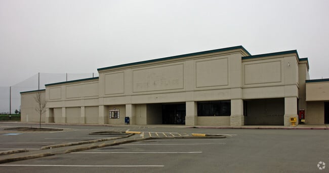
Property Record
330 Dakota St, Sutherlin, OR 97479

Current Lease Availabilities
Property Detail
330 Dakota St
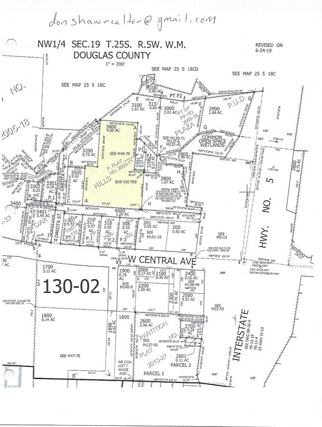
R121766
P.P. 2003-71, PARCEL 1, ACRES 0.27
Commercialnec
Douglas
C3
Oregon
B and X Area of moderate flood hazard, usually the area between the limits of the 100-year and 500-year floods.
1
2025
3.97 AC
2025
Oregon West Area
050001
Other Market Areas
42,583 SF
Roseburg, OR
NEARBY LISTINGS FOR SALE OR LEASE
DEMOGRAPHICS near 330 Dakota St
1 mile
3 mile
5 mile
2025 Total Population
4,524
10,398
12,548
2030 Population
4,657
10,548
12,655
Pop Growth 2025-2030
+ 2.94%
+ 1.44%
+ 0.85%
Average Age
43
44
45
2025 Total Households
1,755
4,231
5,089
HH Growth 2025-2030
+ 2.96%
+ 1.39%
+ 0.81%
Median Household Inc
$49,369
$56,860
$62,757
Avg Household Size
2.50
2.40
2.40
2025 Avg HH Vehicles
2.00
2.00
2.00
Median Home Value
$358,629
$278,684
$312,998
Median Year Built
1991
1986
1983
Nearby Places
Map Layers
Map Styles
 Street
 Aerial
Layers
 Traffic
 Biking
Places
Listings with unknown addresses are not visible on the map
- Restaurants
- Banks
- Shops
- Fitness
- Groceries
Nearby Properties
Address
Land Use
TOTAL SIZE
Lot Size
Zoning
Address
Land Use
TOTAL SIZE
Lot Size
Zoning
1,250 SF
6.34 AC
STR
Address
Land Use
TOTAL SIZE
Lot Size
Zoning
32.83 AC
M2
Address
Land Use
TOTAL SIZE
Lot Size
Zoning
Address
Land Use
TOTAL SIZE
Lot Size
Zoning
2,560 SF
32.65 AC
M2
Address
Land Use
TOTAL SIZE
Lot Size
Zoning
9,420 SF
24.12 AC
CG
Address
Land Use
TOTAL SIZE
Lot Size
Zoning
15.25 AC
WI
Address
Land Use
TOTAL SIZE
Lot Size
Zoning
57,912 SF
2.58 AC
R3
Address
Land Use
TOTAL SIZE
Lot Size
Zoning
17,629 SF
5.52 AC
C3
Address
Land Use
TOTAL SIZE
Lot Size
Zoning
3,264 SF
3.75 AC
C3
Address
Land Use
TOTAL SIZE
Lot Size
Zoning
1,056 SF
4.33 AC
PL
Address
Land Use
TOTAL SIZE
Lot Size
Zoning
9.19 AC
M2
Address
Land Use
TOTAL SIZE
Lot Size
Zoning
80 SF
2.92 AC
C3
Address
Land Use
TOTAL SIZE
Lot Size
Zoning
41,000 SF
3.79 AC
CG
Address
Land Use
TOTAL SIZE
Lot Size
Zoning
27,460 SF
2.24 AC
C3
Address
Land Use
TOTAL SIZE
Lot Size
Zoning
0.55 AC
C3
Address
Land Use
TOTAL SIZE
Lot Size
Zoning
19,433 SF
1.09 AC
R3
Address
Land Use
TOTAL SIZE
Lot Size
Zoning
23,139 SF
1.56 AC
C3
Address
Land Use
TOTAL SIZE
Lot Size
Zoning
26,115 SF
4.46 AC
R2
Address
Land Use
TOTAL SIZE
Lot Size
Zoning
19,283 SF
2.05 AC
R1
Address
Land Use
TOTAL SIZE
Lot Size
Zoning
37,269 SF
4.49 AC
M1
Address
Land Use
TOTAL SIZE
Lot Size
Zoning
123.31 AC
R1
Address
Land Use
TOTAL SIZE
Lot Size
Zoning
9.34 AC
M2
Address
Land Use
TOTAL SIZE
Lot Size
Zoning
30,270 SF
2.50 AC
C3
Address
Land Use
TOTAL SIZE
Lot Size
Zoning
29,468 SF
1.43 AC
R3
Address
Land Use
TOTAL SIZE
Lot Size
Zoning
25,417 SF
1.62 AC
C3
Address
Land Use
TOTAL SIZE
Lot Size
Zoning
11,551 SF
0.51 AC
C3
Address
Land Use
TOTAL SIZE
Lot Size
Zoning
17,291 SF
3.10 AC
R1
Address
Land Use
TOTAL SIZE
Lot Size
Zoning
36,750 SF
4.51 AC
M1
Address
Land Use
TOTAL SIZE
Lot Size
Zoning
4,481 SF
3.51 AC
CG
The World's #1 Commercial Real Estate Marketplace
Connect with us
© 2026 CoStar Group
The information above has been obtained from sources believed reliable. While we do not doubt its accuracy we have not verified it and make no guarantee, warranty or representation about it. It is your responsibility to independently confirm its accuracy and completeness. Any projections, opinions, assumptions, or estimates used are for example only and do not represent the current or future performance of the property. The value of this transaction to you depends on tax and other factors which should be evaluated by your tax, financial, and legal advisors. You and your advisors should conduct a careful, independent investigation of the property to determine to your satisfaction the suitability of the property for your needs.