Property Record
330 E Palace Ave, Santa Fe, NM 87501


Save to a Folder
{{folder.Name}}
{{folder.ListingIds.length}} Properties
{{folder.ListingIds.length}} Property
Create a New Folder
Property Detail
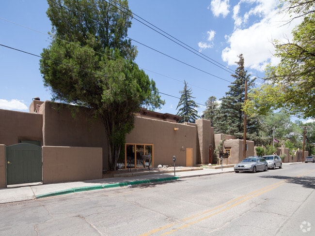
330 E Palace Ave
011297920
T17N R 9E S24 5.133AC
Commercialnec
Santa Fe
B and X Area of moderate flood hazard, usually the area between the limits of the 100-year and 500-year floods.
New Mexico
2025
5.13 AC
2025
Santa Fe
000500
Other Market Areas
6,212 SF
Santa Fe, NM
NEARBY LISTINGS FOR SALE OR LEASE
-
-
View all Santa Fe listings for sale on LoopNet.com
DEMOGRAPHICS near 330 E Palace Ave
1 mile
3 mile
5 mile
2025 Total Population
9,064
40,095
67,656
2030 Population
9,594
41,902
69,767
Pop Growth 2025-2030
+ 5.85%
+ 4.51%
+ 3.12%
Average Age
57
51
51
2025 Total Households
5,219
21,267
33,937
HH Growth 2025-2030
+ 5.77%
+ 4.41%
+ 3.15%
Median Household Inc
$90,339
$77,935
$79,761
Avg Household Size
1.70
1.80
1.90
2025 Avg HH Vehicles
2.00
2.00
2.00
Median Home Value
$913,286
$759,116
$661,975
Median Year Built
1973
1979
1982
Nearby Places
Map Layers
Map Styles
 Street
 Aerial
Layers
 Traffic
 Biking
Places
Listings with unknown addresses are not visible on the map
- Restaurants
- Banks
- Shops
- Fitness
- Groceries
PUBLIC TRANSPORTATION
COMMUTER RAIL
Santa Fe Depot Rail Runner Station (NMRX - Rio Metro Regional Transit District)
Drive
Walk
Distance
Santa Fe Depot Rail Runner Station (NMRX - Rio Metro Regional Transit District)
3 min
20 min
1.1 mi
South Capitol Rail Runner Station (NMRX - Rio Metro Regional Transit District)
Drive
Walk
Distance
South Capitol Rail Runner Station (NMRX - Rio Metro Regional Transit District)
5 min
2.2 mi
AIRPORT
Santa Fe Regional
Drive
Walk
Distance
Santa Fe Regional
22 min
10.6 mi
Freight Ports
Tulsa Port Of Catoosa
Drive
Walk
Distance
Tulsa Port Of Catoosa
688 min
654.6 mi
Nearby Properties
Address
Land Use
TOTAL SIZE
Lot Size
Zoning
Address
Land Use
TOTAL SIZE
Lot Size
Zoning
103.78 AC
Address
Land Use
TOTAL SIZE
Lot Size
Zoning
Address
Land Use
TOTAL SIZE
Lot Size
Zoning
Address
Land Use
TOTAL SIZE
Lot Size
Zoning
0.80 AC
Address
Land Use
TOTAL SIZE
Lot Size
Zoning
Address
Land Use
TOTAL SIZE
Lot Size
Zoning
17.18 AC
Address
Land Use
TOTAL SIZE
Lot Size
Zoning
21.49 AC
Address
Land Use
TOTAL SIZE
Lot Size
Zoning
7.32 AC
Address
Land Use
TOTAL SIZE
Lot Size
Zoning
Address
Land Use
TOTAL SIZE
Lot Size
Zoning
Address
Land Use
TOTAL SIZE
Lot Size
Zoning
Address
Land Use
TOTAL SIZE
Lot Size
Zoning
5.72 AC
Address
Land Use
TOTAL SIZE
Lot Size
Zoning
Address
Land Use
TOTAL SIZE
Lot Size
Zoning
Address
Land Use
TOTAL SIZE
Lot Size
Zoning
Address
Land Use
TOTAL SIZE
Lot Size
Zoning
26.30 AC
Address
Land Use
TOTAL SIZE
Lot Size
Zoning
4.40 AC
Address
Land Use
TOTAL SIZE
Lot Size
Zoning
Address
Land Use
TOTAL SIZE
Lot Size
Zoning
1.08 AC
Address
Land Use
TOTAL SIZE
Lot Size
Zoning
0.25 AC
Address
Land Use
TOTAL SIZE
Lot Size
Zoning
18.25 AC
Address
Land Use
TOTAL SIZE
Lot Size
Zoning
Address
Land Use
TOTAL SIZE
Lot Size
Zoning
Address
Land Use
TOTAL SIZE
Lot Size
Zoning
19.93 AC
Address
Land Use
TOTAL SIZE
Lot Size
Zoning
3.75 AC
Address
Land Use
TOTAL SIZE
Lot Size
Zoning
7.02 AC
Address
Land Use
TOTAL SIZE
Lot Size
Zoning
19,690 SF
3.29 AC
Address
Land Use
TOTAL SIZE
Lot Size
Zoning
Address
Land Use
TOTAL SIZE
Lot Size
Zoning
The World's #1 Commercial Real Estate Marketplace
Connect with us
© 2026 CoStar Group
The information above has been obtained from sources believed reliable. While we do not doubt its accuracy we have not verified it and make no guarantee, warranty or representation about it. It is your responsibility to independently confirm its accuracy and completeness. Any projections, opinions, assumptions, or estimates used are for example only and do not represent the current or future performance of the property. The value of this transaction to you depends on tax and other factors which should be evaluated by your tax, financial, and legal advisors. You and your advisors should conduct a careful, independent investigation of the property to determine to your satisfaction the suitability of the property for your needs.