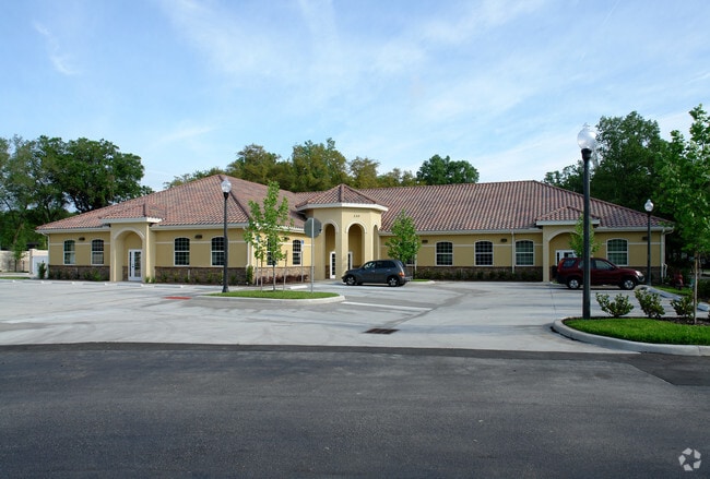
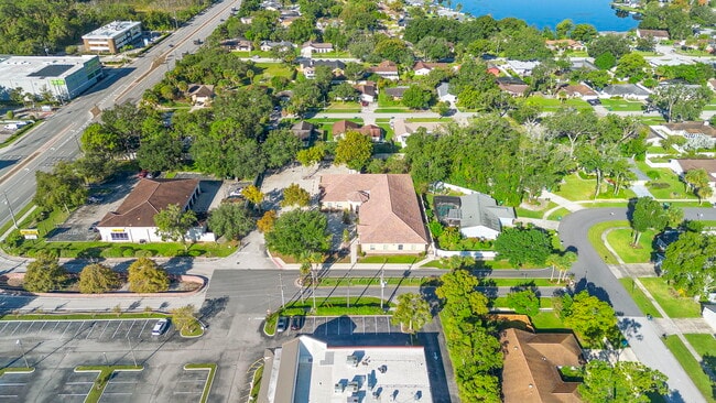
Property Record
330 Harbour Isle Way, Longwood, FL 32750


Current Lease Availabilities
NEARBY LISTINGS FOR SALE OR LEASE
Property Detail
330 Harbour Isle Way
36-20-29-300-024D-0000
SEC 36 TWP 20S RGE 29E W 205 FT OF E 1509.64 FT OF N 180 FT OF S 488.71 FT OF SE 1/4
Privateschool
Seminole
X
Florida
12117C0155F
0.85 AC
2025
Longwood
2025
Orlando
021505
Orlando-Kissimmee-Sanford, FL
9,469 SF
DEMOGRAPHICS near 330 Harbour Isle Way
1 Mile
3 Mile
5 Mile
2024 Total Population
8,598
79,052
204,115
2029 Population
9,154
82,871
212,357
Pop Growth 2024-2029
+ 6.47%
+ 4.83%
+ 4.04%
Average Age
46
42
42
2024 Total Households
3,119
33,480
83,802
HH Growth 2024-2029
+ 6.76%
+ 5.03%
+ 4.22%
Median Household Inc
$85,069
$65,892
$66,549
Avg Household Size
2.60
2.30
2.40
2024 Avg HH Vehicles
2.00
2.00
2.00
Median Home Value
$333,529
$309,145
$314,338
Median Year Built
1978
1983
1982
Nearby Places
Map Layers
Map Styles
 Street
 Aerial
- Restaurants
- Banks
- Shops
- Fitness
- Groceries
PUBLIC TRANSPORTATION
COMMUTER RAIL
DRIVE
WALK
Distance
5 min
2.0 mi
DRIVE
WALK
Distance
9 min
4.3 mi
AIRPORT
Orlando Sanford International
DRIVE
WALK
Distance
Orlando Sanford International
22 min
11.5 mi
Orlando International
DRIVE
WALK
Distance
Orlando International
38 min
21.0 mi
Daytona Beach International
DRIVE
WALK
Distance
Daytona Beach International
53 min
43.0 mi
Freight Ports
Port Canaveral
DRIVE
WALK
Distance
Port Canaveral
83 min
63.0 mi
Nearby Properties
Address
Land Use
TOTAL SIZE
Lot Size
Zoning
Address
Land Use
TOTAL SIZE
Lot Size
Zoning
88,256 SF
39.64 AC
MOC3
Address
Land Use
TOTAL SIZE
Lot Size
Zoning
423,270 SF
3.45 AC
MOC3
Address
Land Use
TOTAL SIZE
Lot Size
Zoning
21.25 AC
GC
Address
Land Use
TOTAL SIZE
Lot Size
Zoning
130,246 SF
71.01 AC
PUD
Address
Land Use
TOTAL SIZE
Lot Size
Zoning
629,182 SF
1.81 AC
R1A
Address
Land Use
TOTAL SIZE
Lot Size
Zoning
391,714 SF
42.59 AC
A1
Address
Land Use
TOTAL SIZE
Lot Size
Zoning
1,416 SF
23.80 AC
Address
Land Use
TOTAL SIZE
Lot Size
Zoning
Address
Land Use
TOTAL SIZE
Lot Size
Zoning
206 SF
1.43 AC
VMU
Address
Land Use
TOTAL SIZE
Lot Size
Zoning
400 SF
13.82 AC
R1AA
Address
Land Use
TOTAL SIZE
Lot Size
Zoning
5,256 SF
1.10 AC
PUDRES
Address
Land Use
TOTAL SIZE
Lot Size
Zoning
540 SF
7.72 AC
GC
Address
Land Use
TOTAL SIZE
Lot Size
Zoning
231,070 SF
35.59 AC
MOR2
Address
Land Use
TOTAL SIZE
Lot Size
Zoning
350,767 SF
11.12 AC
PUD
Address
Land Use
TOTAL SIZE
Lot Size
Zoning
560,170 SF
32.59 AC
M1A
Address
Land Use
TOTAL SIZE
Lot Size
Zoning
456 SF
9.56 AC
Address
Land Use
TOTAL SIZE
Lot Size
Zoning
1,428 SF
8.56 AC
MOR3
Address
Land Use
TOTAL SIZE
Lot Size
Zoning
97,888 SF
3.72 AC
IND
Address
Land Use
TOTAL SIZE
Lot Size
Zoning
3,658 SF
17.71 AC
PUD
Address
Land Use
TOTAL SIZE
Lot Size
Zoning
3,140 SF
15.89 AC
PUD
Address
Land Use
TOTAL SIZE
Lot Size
Zoning
3,370 SF
18.59 AC
PUD
Address
Land Use
TOTAL SIZE
Lot Size
Zoning
17,728 SF
14.64 AC
GC
Address
Land Use
TOTAL SIZE
Lot Size
Zoning
279,457 SF
20.56 AC
R3
Address
Land Use
TOTAL SIZE
Lot Size
Zoning
6,466 SF
18.97 AC
MOC3
Address
Land Use
TOTAL SIZE
Lot Size
Zoning
204 SF
30 AC
R3
Address
Land Use
TOTAL SIZE
Lot Size
Zoning
259,436 SF
11.23 AC
A1
Address
Land Use
TOTAL SIZE
Lot Size
Zoning
194,651 SF
13.14 AC
R3
Address
Land Use
TOTAL SIZE
Lot Size
Zoning
147,310 SF
14.74 AC
GC
Address
Land Use
TOTAL SIZE
Lot Size
Zoning
390,293 SF
47.33 AC
PI
Address
Land Use
TOTAL SIZE
Lot Size
Zoning
2,062 SF
7.30 AC
MOR2
The World's #1 Commercial Real Estate Marketplace
Connect with us
© 2026 CoStar Group
The information above has been obtained from sources believed reliable. While we do not doubt its accuracy we have not verified it and make no guarantee, warranty or representation about it. It is your responsibility to independently confirm its accuracy and completeness. Any projections, opinions, assumptions, or estimates used are for example only and do not represent the current or future performance of the property. The value of this transaction to you depends on tax and other factors which should be evaluated by your tax, financial, and legal advisors. You and your advisors should conduct a careful, independent investigation of the property to determine to your satisfaction the suitability of the property for your needs.