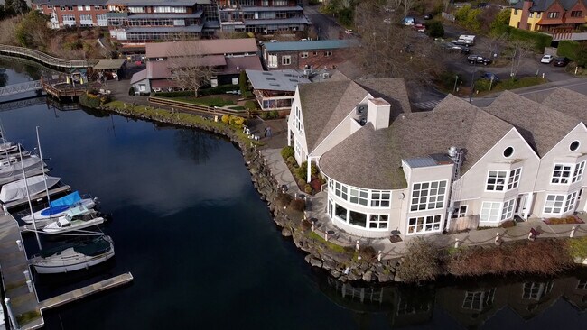
Property Record
330 Madison Ave S, Bainbridge Island, WA 98110


NEARBY LISTINGS FOR SALE OR LEASE
Property Detail
330 Madison Ave S
Bremerton-Silverdale-Port Orchard, WA
Sp 8208230094
262502-3-096-2004
THAT PORTION OF GOVERNMENT LOT 4, SECTION 26, TOWNSHIP 25 NORTH, RANGE 2 EAST, W.M., IN KITSAP COUNTY, WASHINGTON, AND THAT PORTION OF THE SECOND CLASS TIDELANDS, SITUATE IN FRONT OF SAID GOVERNMENT LOT 4, SECTION 26 AND GOVERNMENT LOT 4, SECTION 27,
Miscellaneous
Kitsap
AE
Washington
53035C0382F
4
2025
0.47 AC
2026
Bainbridge Island
090901
Bremerton/Silverdale
9,433 SF
DEMOGRAPHICS near 330 Madison Ave S
1 Mile
3 Mile
5 Mile
2024 Total Population
6,985
17,622
38,433
2029 Population
7,121
17,871
38,651
Pop Growth 2024-2029
+ 1.95%
+ 1.41%
+ 0.57%
Average Age
50
48
45
2024 Total Households
3,325
7,374
15,254
HH Growth 2024-2029
+ 1.80%
+ 1.40%
+ 0.62%
Median Household Inc
$121,905
$152,846
$124,232
Avg Household Size
2.10
2.30
2.50
2024 Avg HH Vehicles
1.00
2.00
2.00
Median Home Value
$867,618
$936,886
$749,188
Median Year Built
1993
1990
1984
Nearby Places
Map Layers
Map Styles
 Street
 Aerial
- Restaurants
- Banks
- Shops
- Fitness
- Groceries
PUBLIC TRANSPORTATION
AIRPORT
Seattle Paine Field International
DRIVE
WALK
Distance
Seattle Paine Field International
81 min
33.4 mi
Freight Ports
Port of Everett
DRIVE
WALK
Distance
Port of Everett
91 min
41.4 mi
SALE & LEASE HISTORY
LISTING DATE
SALE/LEASE

Nov 12, 2019
For Lease
Nearby Properties
Address
Land Use
TOTAL SIZE
Lot Size
Zoning
Address
Land Use
TOTAL SIZE
Lot Size
Zoning
302,902 SF
0.33 AC
NC3-200 (M
Address
Land Use
TOTAL SIZE
Lot Size
Zoning
124,473 SF
1.40 AC
R-4.3
Address
Land Use
TOTAL SIZE
Lot Size
Zoning
3,872 SF
252.21 AC
R-0.4
Address
Land Use
TOTAL SIZE
Lot Size
Zoning
77,910 SF
4.62 AC
MAD
Address
Land Use
TOTAL SIZE
Lot Size
Zoning
7.01 AC
CITY
Address
Land Use
TOTAL SIZE
Lot Size
Zoning
74,440 SF
4.36 AC
B/I
Address
Land Use
TOTAL SIZE
Lot Size
Zoning
73,500 SF
4.84 AC
R-2
Address
Land Use
TOTAL SIZE
Lot Size
Zoning
14,536 SF
1.75 AC
MAD
Address
Land Use
TOTAL SIZE
Lot Size
Zoning
29,720 SF
2.75 AC
HS-2
Address
Land Use
TOTAL SIZE
Lot Size
Zoning
52,942 SF
2.07 AC
CORE
Address
Land Use
TOTAL SIZE
Lot Size
Zoning
40,863 SF
3.95 AC
ERICK
Address
Land Use
TOTAL SIZE
Lot Size
Zoning
1,422 SF
1.69 AC
NC
Address
Land Use
TOTAL SIZE
Lot Size
Zoning
26,768 SF
0.46 AC
HS-1
Address
Land Use
TOTAL SIZE
Lot Size
Zoning
43,324 SF
1.54 AC
R-8
Address
Land Use
TOTAL SIZE
Lot Size
Zoning
924 SF
2.36 AC
B/I
Address
Land Use
TOTAL SIZE
Lot Size
Zoning
50,016 SF
1.14 AC
CORE
Address
Land Use
TOTAL SIZE
Lot Size
Zoning
19,826 SF
5.59 AC
R-5
Address
Land Use
TOTAL SIZE
Lot Size
Zoning
46,266 SF
2.22 AC
R-8
Address
Land Use
TOTAL SIZE
Lot Size
Zoning
32,374 SF
4.31 AC
MAD
Address
Land Use
TOTAL SIZE
Lot Size
Zoning
38,262 SF
1.01 AC
MAD
Address
Land Use
TOTAL SIZE
Lot Size
Zoning
22.91 AC
R-0.4
Address
Land Use
TOTAL SIZE
Lot Size
Zoning
38,032 SF
0.90 AC
R-8
Address
Land Use
TOTAL SIZE
Lot Size
Zoning
19,984 SF
7.35 AC
HS-1
Address
Land Use
TOTAL SIZE
Lot Size
Zoning
31,936 SF
2.35 AC
MAD
Address
Land Use
TOTAL SIZE
Lot Size
Zoning
25,695 SF
2.02 AC
B/I
Address
Land Use
TOTAL SIZE
Lot Size
Zoning
460 SF
3.24 AC
R-4.3
Address
Land Use
TOTAL SIZE
Lot Size
Zoning
12,475 SF
0.95 AC
CORE
Address
Land Use
TOTAL SIZE
Lot Size
Zoning
46,699 SF
7.35 AC
HS-1
Address
Land Use
TOTAL SIZE
Lot Size
Zoning
2.10 AC
CITY
Address
Land Use
TOTAL SIZE
Lot Size
Zoning
25,370 SF
0.83 AC
NC
The World's #1 Commercial Real Estate Marketplace
Connect with us
© 2026 CoStar Group
The information above has been obtained from sources believed reliable. While we do not doubt its accuracy we have not verified it and make no guarantee, warranty or representation about it. It is your responsibility to independently confirm its accuracy and completeness. Any projections, opinions, assumptions, or estimates used are for example only and do not represent the current or future performance of the property. The value of this transaction to you depends on tax and other factors which should be evaluated by your tax, financial, and legal advisors. You and your advisors should conduct a careful, independent investigation of the property to determine to your satisfaction the suitability of the property for your needs.