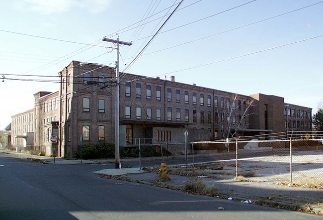
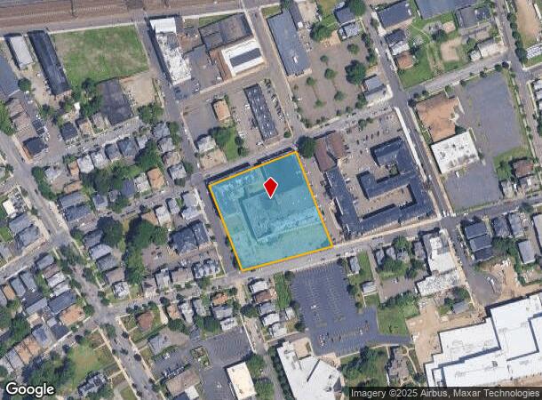
Property Record
330 Myrtle Ave, Bridgeport, CT 06604

NEARBY LISTINGS FOR SALE OR LEASE
Property Detail
330 Myrtle Ave
BRID-000524-000001A
Fairfield
Industrialgeneral
Connecticut
AE
1-a
09001C0437G
2.34 AC
2025
Bridgeport
2025
Westchester/So Connecticut
071300
Bridgeport-Stamford-Danbury, CT
DEMOGRAPHICS near 330 Myrtle Ave
1 mile
3 mile
5 mile
2024 Total Population
14,625
142,930
253,193
2029 Population
14,617
142,688
253,585
Pop Growth 2024-2029
(0.05%)
(0.17%)
+ 0.15%
Average Age
36
37
38
2024 Total Households
5,718
52,768
91,068
HH Growth 2024-2029
(0.33%)
(0.19%)
+ 0.11%
Median Household Inc
$29,898
$48,255
$66,577
Avg Household Size
2.20
2.60
2.60
2024 Avg HH Vehicles
1.00
1.00
2.00
Median Home Value
$139,137
$244,429
$301,543
Median Year Built
1947
1949
1954
Nearby Places
Map Layers
Map Styles
 Street
 Aerial
Transit
 Traffic
 Biking
Places
Listings with unknown addresses are not visible on the map
- Restaurants
- Banks
- Shops
- Fitness
- Groceries
PUBLIC TRANSPORTATION
TRANSIT/SUBWAY
Bridgeport Station (New Haven Line - Metro-North Commuter Railroad Company (Metro-North))
Drive
Walk
Distance
Bridgeport Station (New Haven Line - Metro-North Commuter Railroad Company (Metro-North))
2 min
16 min
0.8 mi
COMMUTER RAIL
Bridgeport Station (New Haven Line - Metro-North Commuter Railroad Company (Metro-North))
Drive
Walk
Distance
Bridgeport Station (New Haven Line - Metro-North Commuter Railroad Company (Metro-North))
2 min
16 min
0.8 mi
Drive
Walk
Distance
7 min
3.2 mi
AIRPORT
Tweed/New Haven
Drive
Walk
Distance
Tweed/New Haven
38 min
22.6 mi
Long Island MacArthur
Drive
Walk
Distance
Long Island MacArthur
107 min
34.2 mi
Westchester County
Drive
Walk
Distance
Westchester County
53 min
34.3 mi
Freight Ports
Port of New Haven
Drive
Walk
Distance
Port of New Haven
32 min
20.5 mi
SALE & LEASE HISTORY
LISTING DATE
SALE/LEASE

Apr 27, 2018
For Sale
Nearby Properties
Address
Land Use
TOTAL SIZE
Lot Size
Zoning
Address
Land Use
TOTAL SIZE
Lot Size
Zoning
Address
Land Use
TOTAL SIZE
Lot Size
Zoning
22.85 AC
Address
Land Use
TOTAL SIZE
Lot Size
Zoning
23.95 AC
RB
Address
Land Use
TOTAL SIZE
Lot Size
Zoning
145,000 SF
15.70 AC
ILI
Address
Land Use
TOTAL SIZE
Lot Size
Zoning
111 AC
RA
Address
Land Use
TOTAL SIZE
Lot Size
Zoning
335,633 SF
39.70 AC
R3
Address
Land Use
TOTAL SIZE
Lot Size
Zoning
4.14 AC
MUEM
Address
Land Use
TOTAL SIZE
Lot Size
Zoning
1,183 SF
2.33 AC
DID
Address
Land Use
TOTAL SIZE
Lot Size
Zoning
178,265 SF
6.92 AC
Address
Land Use
TOTAL SIZE
Lot Size
Zoning
83,122 SF
4.39 AC
Address
Land Use
TOTAL SIZE
Lot Size
Zoning
288,875 SF
1.57 AC
MUEM
Address
Land Use
TOTAL SIZE
Lot Size
Zoning
146,351 SF
8.86 AC
Address
Land Use
TOTAL SIZE
Lot Size
Zoning
497,430 SF
4.16 AC
DCB
Address
Land Use
TOTAL SIZE
Lot Size
Zoning
23 AC
RC
Address
Land Use
TOTAL SIZE
Lot Size
Zoning
162,376 SF
7.82 AC
Address
Land Use
TOTAL SIZE
Lot Size
Zoning
10.66 AC
ORR
Address
Land Use
TOTAL SIZE
Lot Size
Zoning
10.28 AC
DID
Address
Land Use
TOTAL SIZE
Lot Size
Zoning
260,992 SF
4.19 AC
ILI
Address
Land Use
TOTAL SIZE
Lot Size
Zoning
585,480 SF
3.66 AC
Address
Land Use
TOTAL SIZE
Lot Size
Zoning
493,114 SF
2.20 AC
DCB
Address
Land Use
TOTAL SIZE
Lot Size
Zoning
23.70 AC
RB
Address
Land Use
TOTAL SIZE
Lot Size
Zoning
92,318 SF
5.33 AC
Address
Land Use
TOTAL SIZE
Lot Size
Zoning
115,006 SF
2.51 AC
DCD
Address
Land Use
TOTAL SIZE
Lot Size
Zoning
368,000 SF
18.69 AC
D-17
Address
Land Use
TOTAL SIZE
Lot Size
Zoning
216,972 SF
2.53 AC
DCB
Address
Land Use
TOTAL SIZE
Lot Size
Zoning
225,264 SF
28.22 AC
MC
Address
Land Use
TOTAL SIZE
Lot Size
Zoning
14.90 AC
RC
Address
Land Use
TOTAL SIZE
Lot Size
Zoning
5.31 AC
RC
Address
Land Use
TOTAL SIZE
Lot Size
Zoning
16.73 AC
DCD
Address
Land Use
TOTAL SIZE
Lot Size
Zoning
204,000 SF
1.84 AC
MUEM
The World's #1 Commercial Real Estate Marketplace
Connect with us
© 2026 CoStar Group
The information above has been obtained from sources believed reliable. While we do not doubt its accuracy we have not verified it and make no guarantee, warranty or representation about it. It is your responsibility to independently confirm its accuracy and completeness. Any projections, opinions, assumptions, or estimates used are for example only and do not represent the current or future performance of the property. The value of this transaction to you depends on tax and other factors which should be evaluated by your tax, financial, and legal advisors. You and your advisors should conduct a careful, independent investigation of the property to determine to your satisfaction the suitability of the property for your needs.