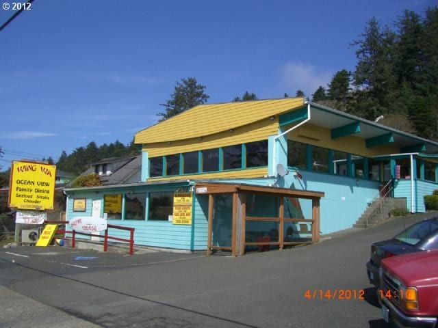
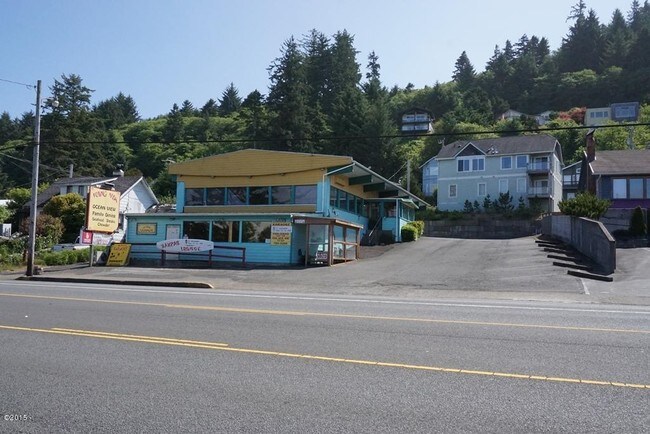
Property Record
330 N Highway 101, Depoe Bay, OR 97341
Property Detail
330 N Highway 101
R444012
DEPOE BAY, BLOCK 12, LOT 7 & 13,PTNS OF, MF311-1131
Commercialnec
Lincoln
C-1
Oregon
B and X Area of moderate flood hazard, usually the area between the limits of the 100-year and 500-year floods.
7,13
2025
0.15 AC
2025
Oregon West Area
9501001113
Other Market Areas
2,900 SF
Newport, OR
NEARBY LISTINGS FOR SALE OR LEASE
-
-
View all Depoe Bay listings for sale on LoopNet.com
DEMOGRAPHICS near 330 N Highway 101
1 mile
3 mile
5 mile
2024 Total Population
1,626
3,372
5,016
2029 Population
1,704
3,568
5,199
Pop Growth 2024-2029
+ 4.80%
+ 5.81%
+ 3.65%
Average Age
53
54
55
2024 Total Households
792
1,663
2,497
HH Growth 2024-2029
+ 4.92%
+ 5.89%
+ 3.56%
Median Household Inc
$73,635
$67,665
$71,169
Avg Household Size
2.00
2.00
2.00
2024 Avg HH Vehicles
2.00
2.00
2.00
Median Home Value
$435,625
$468,471
$474,276
Median Year Built
1995
1992
1989
Nearby Places
Map Layers
Map Styles
 Street
 Aerial
Transit
 Traffic
 Biking
Places
Listings with unknown addresses are not visible on the map
- Restaurants
- Banks
- Shops
- Fitness
- Groceries
SALE & LEASE HISTORY
LISTING DATE
SALE/LEASE

Sep 24, 2016
For Sale
Oct 01, 2019
For Sale
Nearby Properties
Address
Land Use
TOTAL SIZE
Lot Size
Zoning
Address
Land Use
TOTAL SIZE
Lot Size
Zoning
3.36 AC
R-4 PD
Address
Land Use
TOTAL SIZE
Lot Size
Zoning
42.71 AC
R-1,C-1
Address
Land Use
TOTAL SIZE
Lot Size
Zoning
5.53 AC
M-P
Address
Land Use
TOTAL SIZE
Lot Size
Zoning
16,107 SF
1.12 AC
C-T
Address
Land Use
TOTAL SIZE
Lot Size
Zoning
10,182 SF
0.47 AC
C-1
Address
Land Use
TOTAL SIZE
Lot Size
Zoning
12,289 SF
2.34 AC
C-T,RC
Address
Land Use
TOTAL SIZE
Lot Size
Zoning
11,028 SF
1.96 AC
C-T,RC
Address
Land Use
TOTAL SIZE
Lot Size
Zoning
23,647 SF
1.82 AC
L-I
Address
Land Use
TOTAL SIZE
Lot Size
Zoning
0.52 AC
R-2
Address
Land Use
TOTAL SIZE
Lot Size
Zoning
9,026 SF
1.55 AC
C-T,RC
Address
Land Use
TOTAL SIZE
Lot Size
Zoning
1,720 SF
1.33 AC
C-1
Address
Land Use
TOTAL SIZE
Lot Size
Zoning
4,400 SF
0.21 AC
L-I
Address
Land Use
TOTAL SIZE
Lot Size
Zoning
2.40 AC
L-I
Address
Land Use
TOTAL SIZE
Lot Size
Zoning
0.44 AC
M-P
Address
Land Use
TOTAL SIZE
Lot Size
Zoning
6,248 SF
0.23 AC
C-1
Address
Land Use
TOTAL SIZE
Lot Size
Zoning
3,533 SF
0.29 AC
C-1
Address
Land Use
TOTAL SIZE
Lot Size
Zoning
10,238 SF
0.11 AC
C-1
Address
Land Use
TOTAL SIZE
Lot Size
Zoning
7,252 SF
0.17 AC
M-C
Address
Land Use
TOTAL SIZE
Lot Size
Zoning
4,972 SF
0.07 AC
C-1
Address
Land Use
TOTAL SIZE
Lot Size
Zoning
2,135 SF
0.92 AC
L-I
Address
Land Use
TOTAL SIZE
Lot Size
Zoning
3,332 SF
2.85 AC
C-1
Address
Land Use
TOTAL SIZE
Lot Size
Zoning
4,772 SF
0.11 AC
C-1
Address
Land Use
TOTAL SIZE
Lot Size
Zoning
899 SF
1.87 AC
L-I
Address
Land Use
TOTAL SIZE
Lot Size
Zoning
6,920 SF
0.45 AC
C-1
Address
Land Use
TOTAL SIZE
Lot Size
Zoning
4,133 SF
0.73 AC
C-1
Address
Land Use
TOTAL SIZE
Lot Size
Zoning
7,279 SF
0.53 AC
C-1
Address
Land Use
TOTAL SIZE
Lot Size
Zoning
4,912 SF
0.11 AC
C-1
Address
Land Use
TOTAL SIZE
Lot Size
Zoning
6,672 SF
0.10 AC
C-1
Address
Land Use
TOTAL SIZE
Lot Size
Zoning
10,952 SF
1 AC
R-5
Address
Land Use
TOTAL SIZE
Lot Size
Zoning
2,818 SF
0.11 AC
C-1
The World's #1 Commercial Real Estate Marketplace
Connect with us
© 2026 CoStar Group
The information above has been obtained from sources believed reliable. While we do not doubt its accuracy we have not verified it and make no guarantee, warranty or representation about it. It is your responsibility to independently confirm its accuracy and completeness. Any projections, opinions, assumptions, or estimates used are for example only and do not represent the current or future performance of the property. The value of this transaction to you depends on tax and other factors which should be evaluated by your tax, financial, and legal advisors. You and your advisors should conduct a careful, independent investigation of the property to determine to your satisfaction the suitability of the property for your needs.