Property Record
330 N Spur 63, Longview, TX 75601

Property Detail
330 N Spur 63
Longview, TX
LT 23 NCB 2 LONGVIEW MC NUTT ACREAGE
32933
Gregg
Commercialnec
Texas
C and X Area of minimal flood hazard, usually depicted on FIRMs as above the 500-year flood level.
23
2024
1.20 AC
2025
Longview
000502
Other Market Areas
6,139 SF
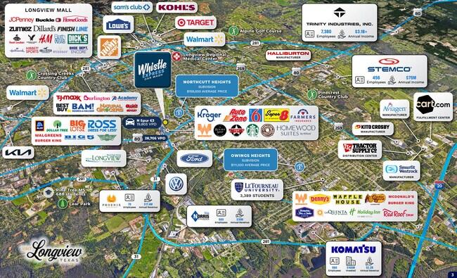
NEARBY LISTINGS FOR SALE OR LEASE
DEMOGRAPHICS near 330 N Spur 63
1 mile
3 mile
5 mile
2024 Total Population
4,876
47,191
84,347
2029 Population
4,983
48,307
86,108
Pop Growth 2024-2029
+ 2.19%
+ 2.36%
+ 2.09%
Average Age
39
39
38
2024 Total Households
1,802
19,026
33,238
HH Growth 2024-2029
+ 2.28%
+ 2.38%
+ 2.13%
Median Household Inc
$65,229
$58,348
$60,994
Avg Household Size
2.30
2.30
2.40
2024 Avg HH Vehicles
2.00
2.00
2.00
Median Home Value
$190,815
$182,126
$195,272
Median Year Built
1972
1975
1977
Nearby Places
Map Layers
Map Styles
 Street
 Aerial
Transit
 Traffic
 Biking
Places
Listings with unknown addresses are not visible on the map
- Restaurants
- Banks
- Shops
- Fitness
- Groceries
PUBLIC TRANSPORTATION
COMMUTER RAIL
Longview (Texas Eagle - Amtrak)
Drive
Walk
Distance
Longview (Texas Eagle - Amtrak)
4 min
2.1 mi
Freight Ports
Port of Shreveport
Drive
Walk
Distance
Port of Shreveport
89 min
73.0 mi
SALE & LEASE HISTORY
LISTING DATE
SALE/LEASE

Oct 10, 2023
For Sale
Jan 05, 2024
For Sale
Aug 12, 2025
For Sale
Nearby Properties
Address
Land Use
TOTAL SIZE
Lot Size
Zoning
Address
Land Use
TOTAL SIZE
Lot Size
Zoning
506,149 SF
60.19 AC
Address
Land Use
TOTAL SIZE
Lot Size
Zoning
18,200 SF
151.10 AC
Address
Land Use
TOTAL SIZE
Lot Size
Zoning
372,612 SF
5.72 AC
Address
Land Use
TOTAL SIZE
Lot Size
Zoning
138,850 SF
1.72 AC
Address
Land Use
TOTAL SIZE
Lot Size
Zoning
237,830 SF
15.75 AC
Address
Land Use
TOTAL SIZE
Lot Size
Zoning
84,658 SF
24.31 AC
Address
Land Use
TOTAL SIZE
Lot Size
Zoning
116,362 SF
25.20 AC
Address
Land Use
TOTAL SIZE
Lot Size
Zoning
65,115 SF
Address
Land Use
TOTAL SIZE
Lot Size
Zoning
115,023 SF
13.79 AC
Address
Land Use
TOTAL SIZE
Lot Size
Zoning
280 SF
12.17 AC
Address
Land Use
TOTAL SIZE
Lot Size
Zoning
88,580 SF
21 AC
Address
Land Use
TOTAL SIZE
Lot Size
Zoning
23,556 SF
6.75 AC
Address
Land Use
TOTAL SIZE
Lot Size
Zoning
12.60 AC
Address
Land Use
TOTAL SIZE
Lot Size
Zoning
150,658 SF
32.24 AC
Address
Land Use
TOTAL SIZE
Lot Size
Zoning
58.68 AC
Address
Land Use
TOTAL SIZE
Lot Size
Zoning
92,222 SF
29.77 AC
Address
Land Use
TOTAL SIZE
Lot Size
Zoning
267,277 SF
18.62 AC
Address
Land Use
TOTAL SIZE
Lot Size
Zoning
21,435 SF
15.50 AC
Address
Land Use
TOTAL SIZE
Lot Size
Zoning
56,240 SF
90.65 AC
Address
Land Use
TOTAL SIZE
Lot Size
Zoning
Address
Land Use
TOTAL SIZE
Lot Size
Zoning
181,628 SF
10.35 AC
Address
Land Use
TOTAL SIZE
Lot Size
Zoning
106,831 SF
17.63 AC
Address
Land Use
TOTAL SIZE
Lot Size
Zoning
108,356 SF
0.59 AC
Address
Land Use
TOTAL SIZE
Lot Size
Zoning
156,960 SF
12.43 AC
Address
Land Use
TOTAL SIZE
Lot Size
Zoning
134,176 SF
7.05 AC
Address
Land Use
TOTAL SIZE
Lot Size
Zoning
67,688 SF
7.57 AC
Address
Land Use
TOTAL SIZE
Lot Size
Zoning
10.42 AC
Address
Land Use
TOTAL SIZE
Lot Size
Zoning
11.14 AC
Address
Land Use
TOTAL SIZE
Lot Size
Zoning
Address
Land Use
TOTAL SIZE
Lot Size
Zoning
34,978 SF
11.62 AC
The World's #1 Commercial Real Estate Marketplace
Connect with us
© 2026 CoStar Group
The information above has been obtained from sources believed reliable. While we do not doubt its accuracy we have not verified it and make no guarantee, warranty or representation about it. It is your responsibility to independently confirm its accuracy and completeness. Any projections, opinions, assumptions, or estimates used are for example only and do not represent the current or future performance of the property. The value of this transaction to you depends on tax and other factors which should be evaluated by your tax, financial, and legal advisors. You and your advisors should conduct a careful, independent investigation of the property to determine to your satisfaction the suitability of the property for your needs.