Property Record
330 Office Ct, Fairview Heights, IL 62208
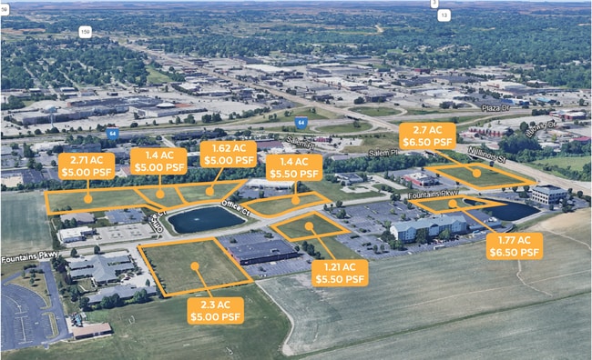

This Property Is For Sale
NEARBY LISTINGS FOR SALE OR LEASE
Property Detail
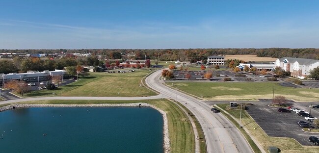
330 Office Ct
St. Louis
Fountains Court Resub
St. Louis, MO-IL
FOUNTAINS COURT RESUB LOT 1
03-22.0-307-017
St. Clair
Commercialacreage
Illinois
2024
1
2024
1.41 AC
503404
Illinois
DEMOGRAPHICS near 330 Office Ct
1 Mile
3 Mile
5 Mile
2024 Total Population
3,243
29,009
101,902
2029 Population
3,129
27,945
98,733
Pop Growth 2024-2029
(3.52%)
(3.67%)
(3.11%)
Average Age
37
41
41
2024 Total Households
1,159
11,763
41,847
HH Growth 2024-2029
(3.62%)
(3.67%)
(3.10%)
Median Household Inc
$103,426
$90,583
$77,048
Avg Household Size
2.80
2.40
2.40
2024 Avg HH Vehicles
2.00
2.00
2.00
Median Home Value
$209,804
$191,767
$180,318
Median Year Built
1995
1988
1981
Nearby Places
Map Layers
Map Styles
 Street
 Aerial
- Restaurants
- Banks
- Shops
- Fitness
- Groceries
PUBLIC TRANSPORTATION
COMMUTER RAIL
Fairview Heights (Lambert Airport Shiloh-Scott - St. Louis MetroLink (MetroLink), Shrewsbury-Lansdowne I-44 Emerson Park - St. Louis MetroLink (MetroLink))
DRIVE
WALK
Distance
Fairview Heights (Lambert Airport Shiloh-Scott - St. Louis MetroLink (MetroLink), Shrewsbury-Lansdowne I-44 Emerson Park - St. Louis MetroLink (MetroLink))
9 min
4.7 mi
Memorial Hospital (Lambert Airport Shiloh-Scott - St. Louis MetroLink (MetroLink))
DRIVE
WALK
Distance
Memorial Hospital (Lambert Airport Shiloh-Scott - St. Louis MetroLink (MetroLink))
8 min
4.7 mi
AIRPORT
Scott AFB/Midamerica St Louis
DRIVE
WALK
Distance
Scott AFB/Midamerica St Louis
24 min
13.6 mi
St Louis Lambert International
DRIVE
WALK
Distance
St Louis Lambert International
36 min
25.8 mi
Freight Ports
Port Milwaukee
DRIVE
WALK
Distance
Port Milwaukee
410 min
362.3 mi
Nearby Properties
Address
Land Use
TOTAL SIZE
Lot Size
Zoning
Address
Land Use
TOTAL SIZE
Lot Size
Zoning
Address
Land Use
TOTAL SIZE
Lot Size
Zoning
21.84 AC
Address
Land Use
TOTAL SIZE
Lot Size
Zoning
2,484 SF
16.76 AC
Address
Land Use
TOTAL SIZE
Lot Size
Zoning
13,440 SF
14.07 AC
Address
Land Use
TOTAL SIZE
Lot Size
Zoning
Address
Land Use
TOTAL SIZE
Lot Size
Zoning
207,910 SF
13.42 AC
Address
Land Use
TOTAL SIZE
Lot Size
Zoning
30.86 AC
Address
Land Use
TOTAL SIZE
Lot Size
Zoning
143,464 SF
10.78 AC
Address
Land Use
TOTAL SIZE
Lot Size
Zoning
Address
Land Use
TOTAL SIZE
Lot Size
Zoning
6,172 SF
7.31 AC
Address
Land Use
TOTAL SIZE
Lot Size
Zoning
5,772 SF
11.48 AC
Address
Land Use
TOTAL SIZE
Lot Size
Zoning
140,850 SF
16.71 AC
Address
Land Use
TOTAL SIZE
Lot Size
Zoning
142,369 SF
12.01 AC
Address
Land Use
TOTAL SIZE
Lot Size
Zoning
1,863 SF
11.46 AC
Address
Land Use
TOTAL SIZE
Lot Size
Zoning
127,251 SF
12.15 AC
Address
Land Use
TOTAL SIZE
Lot Size
Zoning
7,004 SF
9.59 AC
Address
Land Use
TOTAL SIZE
Lot Size
Zoning
7.82 AC
Address
Land Use
TOTAL SIZE
Lot Size
Zoning
74,479 SF
5.96 AC
Address
Land Use
TOTAL SIZE
Lot Size
Zoning
15,888 SF
20.30 AC
Address
Land Use
TOTAL SIZE
Lot Size
Zoning
Address
Land Use
TOTAL SIZE
Lot Size
Zoning
3.57 AC
Address
Land Use
TOTAL SIZE
Lot Size
Zoning
113,880 SF
10.22 AC
Address
Land Use
TOTAL SIZE
Lot Size
Zoning
10,014 SF
3.18 AC
Address
Land Use
TOTAL SIZE
Lot Size
Zoning
64,752 SF
5.57 AC
Address
Land Use
TOTAL SIZE
Lot Size
Zoning
45,378 SF
0.92 AC
Address
Land Use
TOTAL SIZE
Lot Size
Zoning
16,682 SF
2.48 AC
Address
Land Use
TOTAL SIZE
Lot Size
Zoning
6,974 SF
6.14 AC
Address
Land Use
TOTAL SIZE
Lot Size
Zoning
11,005 SF
7.71 AC
Address
Land Use
TOTAL SIZE
Lot Size
Zoning
4,674 SF
9.31 AC
Address
Land Use
TOTAL SIZE
Lot Size
Zoning
8,786 SF
2.08 AC
The World's #1 Commercial Real Estate Marketplace
Connect with us
© 2025 CoStar Group
The information above has been obtained from sources believed reliable. While we do not doubt its accuracy we have not verified it and make no guarantee, warranty or representation about it. It is your responsibility to independently confirm its accuracy and completeness. Any projections, opinions, assumptions, or estimates used are for example only and do not represent the current or future performance of the property. The value of this transaction to you depends on tax and other factors which should be evaluated by your tax, financial, and legal advisors. You and your advisors should conduct a careful, independent investigation of the property to determine to your satisfaction the suitability of the property for your needs.