Property Record
330 River Rd, Willington, CT 06279


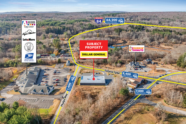
Property Detail
330 River Rd
WILL-000000-000000-103300
TOLLAND
Commercialbuilding
Connecticut
DNC
31-a
2025
2.25 AC
2025
Tolland County
840100
Hartford
5,008 SF
Hartford-West Hartford-East Hartford, CT
NEARBY LISTINGS FOR SALE OR LEASE
-
-
View all Willington listings for sale on LoopNet.com
DEMOGRAPHICS near 330 River Rd
1 mile
3 mile
5 mile
2025 Total Population
646
7,598
22,491
2030 Population
658
7,747
23,008
Pop Growth 2025-2030
+ 1.86%
+ 1.96%
+ 2.30%
Average Age
41
41
40
2025 Total Households
246
3,018
8,706
HH Growth 2025-2030
+ 2.03%
+ 2.05%
+ 2.42%
Median Household Inc
$125,357
$108,022
$103,808
Avg Household Size
2.50
2.50
2.40
2025 Avg HH Vehicles
2.00
2.00
2.00
Median Home Value
$329,824
$333,477
$348,071
Median Year Built
1982
1978
1978
Nearby Places
Map Layers
Map Styles
 Street
 Aerial
Transit
 Traffic
 Biking
Places
Listings with unknown addresses are not visible on the map
- Restaurants
- Banks
- Shops
- Fitness
- Groceries
PUBLIC TRANSPORTATION
AIRPORT
Bradley International
Drive
Walk
Distance
Bradley International
53 min
31.1 mi
Worcester Regional
Drive
Walk
Distance
Worcester Regional
60 min
41.8 mi
Freight Ports
Port of New Haven
Drive
Walk
Distance
Port of New Haven
76 min
59.6 mi
SALE & LEASE HISTORY
LISTING DATE
SALE/LEASE

Nov 11, 2024
For Sale
Mar 07, 2019
For Sale
Jun 01, 2022
For Sale
Jul 08, 2019
For Sale
Nearby Properties
Address
Land Use
TOTAL SIZE
Lot Size
Zoning
Address
Land Use
TOTAL SIZE
Lot Size
Zoning
258,330 SF
68.50 AC
RDD
Address
Land Use
TOTAL SIZE
Lot Size
Zoning
168,410 SF
100.15 AC
RDD
Address
Land Use
TOTAL SIZE
Lot Size
Zoning
48 AC
RDD
Address
Land Use
TOTAL SIZE
Lot Size
Zoning
63,016 SF
8.60 AC
R80
Address
Land Use
TOTAL SIZE
Lot Size
Zoning
113,904 SF
38.80 AC
R80
Address
Land Use
TOTAL SIZE
Lot Size
Zoning
59.01 AC
RDD
Address
Land Use
TOTAL SIZE
Lot Size
Zoning
27.98 AC
RDD
Address
Land Use
TOTAL SIZE
Lot Size
Zoning
28,401 SF
8 AC
R80
Address
Land Use
TOTAL SIZE
Lot Size
Zoning
31,016 SF
23 AC
R80
Address
Land Use
TOTAL SIZE
Lot Size
Zoning
10 AC
RDD
Address
Land Use
TOTAL SIZE
Lot Size
Zoning
33,328 SF
17.48 AC
R80
Address
Land Use
TOTAL SIZE
Lot Size
Zoning
38,054 SF
35.50 AC
R80
Address
Land Use
TOTAL SIZE
Lot Size
Zoning
27,740 SF
11.92 AC
RDD
Address
Land Use
TOTAL SIZE
Lot Size
Zoning
9.05 AC
TCZ
Address
Land Use
TOTAL SIZE
Lot Size
Zoning
10,728 SF
39.68 AC
RDD
Address
Land Use
TOTAL SIZE
Lot Size
Zoning
13,426 SF
4.13 AC
R80
Address
Land Use
TOTAL SIZE
Lot Size
Zoning
462.80 AC
RDD
Address
Land Use
TOTAL SIZE
Lot Size
Zoning
1,200 SF
108 AC
RDD
Address
Land Use
TOTAL SIZE
Lot Size
Zoning
1,132 SF
0.78 AC
RDD
Address
Land Use
TOTAL SIZE
Lot Size
Zoning
1,952 SF
56 AC
R80
Address
Land Use
TOTAL SIZE
Lot Size
Zoning
32,583 SF
16.71 AC
DC
Address
Land Use
TOTAL SIZE
Lot Size
Zoning
22,133 SF
Address
Land Use
TOTAL SIZE
Lot Size
Zoning
44,000 SF
5 AC
DI
Address
Land Use
TOTAL SIZE
Lot Size
Zoning
15.32 AC
TCZ
Address
Land Use
TOTAL SIZE
Lot Size
Zoning
16,128 SF
4.91 AC
TCZ
Address
Land Use
TOTAL SIZE
Lot Size
Zoning
10,848 SF
8 AC
DCR
Address
Land Use
TOTAL SIZE
Lot Size
Zoning
31,200 SF
5.10 AC
DI
Address
Land Use
TOTAL SIZE
Lot Size
Zoning
8,013 SF
20.17 AC
DC
Address
Land Use
TOTAL SIZE
Lot Size
Zoning
4,092 SF
58.96 AC
DER
Address
Land Use
TOTAL SIZE
Lot Size
Zoning
2.30 AC
GDD
The World's #1 Commercial Real Estate Marketplace
Connect with us
© 2026 CoStar Group
The information above has been obtained from sources believed reliable. While we do not doubt its accuracy we have not verified it and make no guarantee, warranty or representation about it. It is your responsibility to independently confirm its accuracy and completeness. Any projections, opinions, assumptions, or estimates used are for example only and do not represent the current or future performance of the property. The value of this transaction to you depends on tax and other factors which should be evaluated by your tax, financial, and legal advisors. You and your advisors should conduct a careful, independent investigation of the property to determine to your satisfaction the suitability of the property for your needs.