Property Record
330 S Laredo St, Belle Plaine, MN 56011
NEARBY LISTINGS FOR SALE OR LEASE
-
-
View all Belle Plaine listings for sale on LoopNet.com
Property Detail
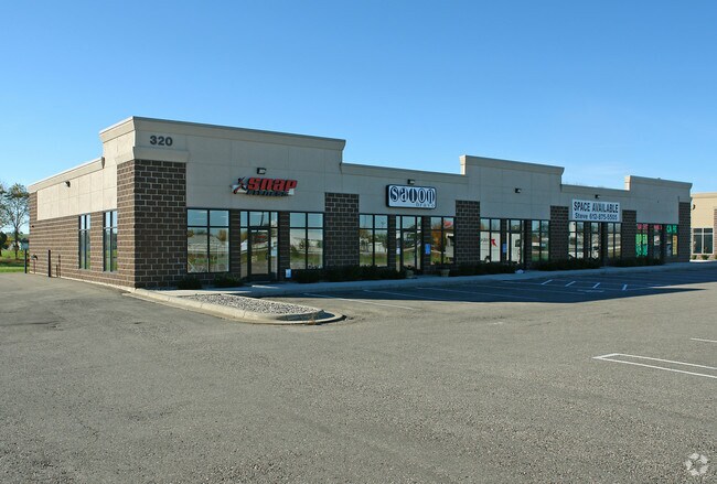
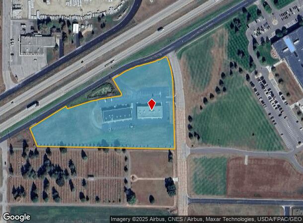
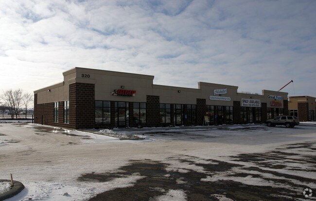
330 S Laredo St
Minneapolis-St. Paul-Bloomington, MN-WI
SECTION 06 TOWNSHIP 113 RANGE 024 P/O SW QUARTER SECTION 6, TOWNSHIP 113, RANGE 24 DESCRIBED AS FOLLOWS: BEGINNING
20-906-014-1
Scott
Commercialnec
Minnesota
2025
6.30 AC
2025
Burnsville
081302
Minneapolis/St Paul
18,000 SF
DEMOGRAPHICS near 330 S Laredo St
1 Mile
3 Mile
5 Mile
2024 Total Population
5,835
8,577
9,660
2029 Population
6,215
9,155
10,288
Pop Growth 2024-2029
+ 6.51%
+ 6.74%
+ 6.50%
Average Age
37
38
38
2024 Total Households
2,072
3,082
3,493
HH Growth 2024-2029
+ 6.85%
+ 7.11%
+ 6.84%
Median Household Inc
$87,676
$86,768
$88,803
Avg Household Size
2.70
2.70
2.70
2024 Avg HH Vehicles
2.00
2.00
2.00
Median Home Value
$260,353
$266,982
$276,854
Median Year Built
1999
1996
1995
Nearby Places
Map Layers
Map Styles
 Street
 Aerial
- Restaurants
- Banks
- Shops
- Fitness
- Groceries
PUBLIC TRANSPORTATION
AIRPORT
Minneapolis-St Paul International/Wold-Chamberlain
DRIVE
WALK
Distance
Minneapolis-St Paul International/Wold-Chamberlain
56 min
40.8 mi
Nearby Properties
Address
Land Use
TOTAL SIZE
Lot Size
Zoning
Address
Land Use
TOTAL SIZE
Lot Size
Zoning
97,268 SF
8.68 AC
Address
Land Use
TOTAL SIZE
Lot Size
Zoning
117,720 SF
4.70 AC
Address
Land Use
TOTAL SIZE
Lot Size
Zoning
87,722 SF
19.83 AC
Address
Land Use
TOTAL SIZE
Lot Size
Zoning
144,016 SF
7.43 AC
Address
Land Use
TOTAL SIZE
Lot Size
Zoning
159,484 SF
29.26 AC
Address
Land Use
TOTAL SIZE
Lot Size
Zoning
69,784 SF
5.26 AC
Address
Land Use
TOTAL SIZE
Lot Size
Zoning
11,610 SF
3.90 AC
Address
Land Use
TOTAL SIZE
Lot Size
Zoning
81,766 SF
0.77 AC
Address
Land Use
TOTAL SIZE
Lot Size
Zoning
41,986 SF
4.90 AC
Address
Land Use
TOTAL SIZE
Lot Size
Zoning
6.15 AC
Address
Land Use
TOTAL SIZE
Lot Size
Zoning
22,942 SF
6.75 AC
Address
Land Use
TOTAL SIZE
Lot Size
Zoning
27,549 SF
2.36 AC
Address
Land Use
TOTAL SIZE
Lot Size
Zoning
16,544 SF
1.52 AC
Address
Land Use
TOTAL SIZE
Lot Size
Zoning
Address
Land Use
TOTAL SIZE
Lot Size
Zoning
10,112 SF
0.98 AC
Address
Land Use
TOTAL SIZE
Lot Size
Zoning
8,406 SF
3.90 AC
Address
Land Use
TOTAL SIZE
Lot Size
Zoning
30,939 SF
8 AC
Address
Land Use
TOTAL SIZE
Lot Size
Zoning
12,211 SF
1.29 AC
Address
Land Use
TOTAL SIZE
Lot Size
Zoning
Address
Land Use
TOTAL SIZE
Lot Size
Zoning
20,255 SF
1.99 AC
Address
Land Use
TOTAL SIZE
Lot Size
Zoning
10,384 SF
1 AC
Address
Land Use
TOTAL SIZE
Lot Size
Zoning
7.23 AC
Address
Land Use
TOTAL SIZE
Lot Size
Zoning
20,000 SF
3.92 AC
Address
Land Use
TOTAL SIZE
Lot Size
Zoning
1.64 AC
Address
Land Use
TOTAL SIZE
Lot Size
Zoning
Address
Land Use
TOTAL SIZE
Lot Size
Zoning
30,742 SF
1.94 AC
Address
Land Use
TOTAL SIZE
Lot Size
Zoning
36,795 SF
7.54 AC
Address
Land Use
TOTAL SIZE
Lot Size
Zoning
7,378 SF
2.56 AC
Address
Land Use
TOTAL SIZE
Lot Size
Zoning
27,640 SF
2.24 AC
Address
Land Use
TOTAL SIZE
Lot Size
Zoning
The World's #1 Commercial Real Estate Marketplace
Connect with us
© 2026 CoStar Group
The information above has been obtained from sources believed reliable. While we do not doubt its accuracy we have not verified it and make no guarantee, warranty or representation about it. It is your responsibility to independently confirm its accuracy and completeness. Any projections, opinions, assumptions, or estimates used are for example only and do not represent the current or future performance of the property. The value of this transaction to you depends on tax and other factors which should be evaluated by your tax, financial, and legal advisors. You and your advisors should conduct a careful, independent investigation of the property to determine to your satisfaction the suitability of the property for your needs.