Property Record
330 W Sycamore St, Fresno, TX 77545
NEARBY LISTINGS FOR SALE OR LEASE
-
-
View all Fresno listings for sale on LoopNet.com
Property Detail
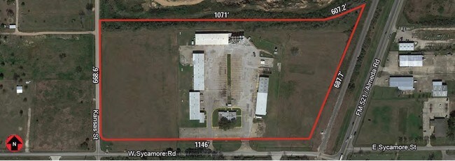
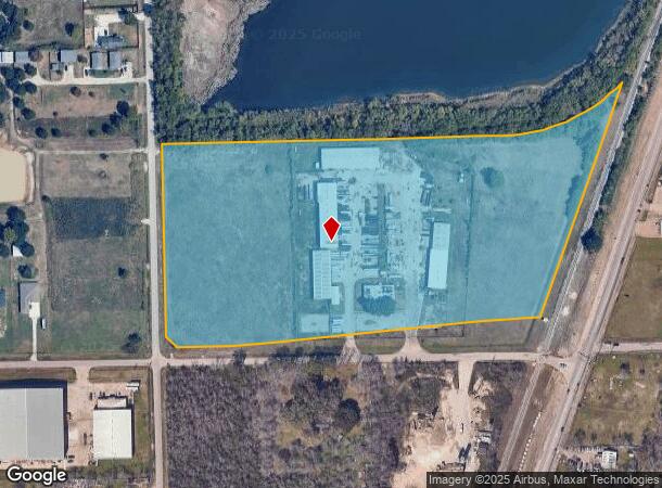
330 W Sycamore St
4600-00-685-0000-907
Magnolia Place
Industrialgeneral
MAGNOLIA PLACE, BLOCK 685,686,687,688, & (PT) BLOCK 656, ACRES 18.309, C=R164469 (HLA)
X
Fort Bend
48039C0015K
Texas
2024
19.62 AC
2025
Southwest Far
670803
Houston
35,605 SF
Houston-The Woodlands-Sugar Land, TX
DEMOGRAPHICS near 330 W Sycamore St
1 Mile
3 Mile
5 Mile
2024 Total Population
9,134
60,662
167,515
2029 Population
11,057
71,553
196,778
Pop Growth 2024-2029
+ 21.05%
+ 17.95%
+ 17.47%
Average Age
34
34
35
2024 Total Households
2,634
18,335
53,232
HH Growth 2024-2029
+ 21.49%
+ 18.34%
+ 17.79%
Median Household Inc
$65,656
$95,443
$95,573
Avg Household Size
3.40
3.30
3.10
2024 Avg HH Vehicles
2.00
2.00
2.00
Median Home Value
$169,861
$277,589
$295,983
Median Year Built
2004
2010
2008
Nearby Places
Map Layers
Map Styles
 Street
 Aerial
- Restaurants
- Banks
- Shops
- Fitness
- Groceries
PUBLIC TRANSPORTATION
AIRPORT
William P Hobby
DRIVE
WALK
Distance
William P Hobby
32 min
17.8 mi
Freight Ports
Port of Houston
DRIVE
WALK
Distance
Port of Houston
37 min
22.4 mi
SALE & LEASE HISTORY
LISTING DATE
SALE/LEASE

Sep 23, 2016
For Sale
Nearby Properties
Address
Land Use
TOTAL SIZE
Lot Size
Zoning
Address
Land Use
TOTAL SIZE
Lot Size
Zoning
81.01 AC
Address
Land Use
TOTAL SIZE
Lot Size
Zoning
344,620 SF
78.14 AC
SY
Address
Land Use
TOTAL SIZE
Lot Size
Zoning
1,764 SF
39.64 AC
ST
Address
Land Use
TOTAL SIZE
Lot Size
Zoning
82,400 SF
10.85 AC
I
Address
Land Use
TOTAL SIZE
Lot Size
Zoning
15.28 AC
0015
Address
Land Use
TOTAL SIZE
Lot Size
Zoning
85,092 SF
12.95 AC
Address
Land Use
TOTAL SIZE
Lot Size
Zoning
105,790 SF
12.82 AC
X
Address
Land Use
TOTAL SIZE
Lot Size
Zoning
13.85 AC
Address
Land Use
TOTAL SIZE
Lot Size
Zoning
132,938 SF
29 AC
MZY
Address
Land Use
TOTAL SIZE
Lot Size
Zoning
4.30 AC
Address
Land Use
TOTAL SIZE
Lot Size
Zoning
98,957 SF
10.70 AC
Address
Land Use
TOTAL SIZE
Lot Size
Zoning
17,481 SF
12.54 AC
Address
Land Use
TOTAL SIZE
Lot Size
Zoning
37,000 SF
6.06 AC
0218
Address
Land Use
TOTAL SIZE
Lot Size
Zoning
Address
Land Use
TOTAL SIZE
Lot Size
Zoning
2.92 AC
Address
Land Use
TOTAL SIZE
Lot Size
Zoning
11,400 SF
2.10 AC
Address
Land Use
TOTAL SIZE
Lot Size
Zoning
68,340 SF
3.74 AC
XS
Address
Land Use
TOTAL SIZE
Lot Size
Zoning
2.31 AC
S
Address
Land Use
TOTAL SIZE
Lot Size
Zoning
7.86 AC
SN
Address
Land Use
TOTAL SIZE
Lot Size
Zoning
14,575 SF
2.13 AC
Address
Land Use
TOTAL SIZE
Lot Size
Zoning
13,134 SF
2.08 AC
Address
Land Use
TOTAL SIZE
Lot Size
Zoning
70,260 SF
4.41 AC
SY
Address
Land Use
TOTAL SIZE
Lot Size
Zoning
361.85 AC
QZY
Address
Land Use
TOTAL SIZE
Lot Size
Zoning
16,512 SF
3.04 AC
Address
Land Use
TOTAL SIZE
Lot Size
Zoning
Address
Land Use
TOTAL SIZE
Lot Size
Zoning
22.59 AC
Address
Land Use
TOTAL SIZE
Lot Size
Zoning
20,770 SF
2.93 AC
XY
Address
Land Use
TOTAL SIZE
Lot Size
Zoning
14,543 SF
2.22 AC
Address
Land Use
TOTAL SIZE
Lot Size
Zoning
Address
Land Use
TOTAL SIZE
Lot Size
Zoning
19,305 SF
1.99 AC
XS
The World's #1 Commercial Real Estate Marketplace
Connect with us
© 2025 CoStar Group
The information above has been obtained from sources believed reliable. While we do not doubt its accuracy we have not verified it and make no guarantee, warranty or representation about it. It is your responsibility to independently confirm its accuracy and completeness. Any projections, opinions, assumptions, or estimates used are for example only and do not represent the current or future performance of the property. The value of this transaction to you depends on tax and other factors which should be evaluated by your tax, financial, and legal advisors. You and your advisors should conduct a careful, independent investigation of the property to determine to your satisfaction the suitability of the property for your needs.