Property Record
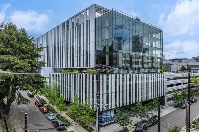
330 Yale Ave N, Seattle, WA 98109


Current Lease Availabilities
NEARBY LISTINGS FOR SALE OR LEASE
Property Detail
330 Yale Ave N
Seattle-Tacoma-Bellevue, WA
Pontius Add
684770-0115
PONTIUS ADD PCL Z SEATTLE BLA #303316-LU REC #20190805900001 SD BLA BEING ALL BLOCK 22 OF SD ADD LESS RD
Officebuilding
King
X
Washington
53033C0630G
11-12
2025
0.68 AC
2024
Lake Union
006703
Seattle/Puget Sound
247,773 SF
DEMOGRAPHICS near 330 Yale Ave N
1 Mile
3 Mile
5 Mile
2024 Total Population
94,742
289,304
519,957
2029 Population
97,299
295,910
528,768
Pop Growth 2024-2029
+ 2.70%
+ 2.28%
+ 1.69%
Average Age
37
37
38
2024 Total Households
61,470
156,796
257,999
HH Growth 2024-2029
+ 2.59%
+ 2.32%
+ 1.78%
Median Household Inc
$111,713
$110,158
$117,735
Avg Household Size
1.50
1.70
1.90
2024 Avg HH Vehicles
1.00
1.00
1.00
Median Home Value
$866,855
$999,756
$969,495
Median Year Built
2000
1990
1981
Nearby Places
Map Layers
Map Styles
 Street
 Aerial
- Restaurants
- Banks
- Shops
- Fitness
- Groceries
PUBLIC TRANSPORTATION
TRANSIT/SUBWAY
Terry Ave N & Thomas St (South Lake Union Streetcar - Seattle Streetcar)
DRIVE
WALK
Distance
Terry Ave N & Thomas St (South Lake Union Streetcar - Seattle Streetcar)
2 min
8 min
0.4 mi
Terry & Thomas (South Lake Union Streetcar - Seattle Streetcar)
DRIVE
WALK
Distance
Terry & Thomas (South Lake Union Streetcar - Seattle Streetcar)
2 min
8 min
0.4 mi
Terry & Mercer (South Lake Union Streetcar - Seattle Streetcar)
DRIVE
WALK
Distance
Terry & Mercer (South Lake Union Streetcar - Seattle Streetcar)
2 min
9 min
0.5 mi
Terry Ave N & Republican St (South Lake Union Streetcar - Seattle Streetcar)
DRIVE
WALK
Distance
Terry Ave N & Republican St (South Lake Union Streetcar - Seattle Streetcar)
2 min
9 min
0.5 mi
Westlake & Thomas (South Lake Union Streetcar - Seattle Streetcar)
DRIVE
WALK
Distance
Westlake & Thomas (South Lake Union Streetcar - Seattle Streetcar)
2 min
9 min
0.5 mi
COMMUTER RAIL
King Street (Seattle) Station (Sounder South Line - Central Puget Sound Regional Transit Authority Rail (Link Light Rail/Sounder))
DRIVE
WALK
Distance
King Street (Seattle) Station (Sounder South Line - Central Puget Sound Regional Transit Authority Rail (Link Light Rail/Sounder))
5 min
2.5 mi
AIRPORT
Seattle-Tacoma International
DRIVE
WALK
Distance
Seattle-Tacoma International
17 min
14.6 mi
Freight Ports
Port of Seattle
DRIVE
WALK
Distance
Port of Seattle
1 min
3.8 mi
Nearby Properties
Address
Land Use
TOTAL SIZE
Lot Size
Zoning
Address
Land Use
TOTAL SIZE
Lot Size
Zoning
800,000 SF
8.57 AC
SM-UP 95 (
Address
Land Use
TOTAL SIZE
Lot Size
Zoning
471.20 AC
MIO-37-LR1
Address
Land Use
TOTAL SIZE
Lot Size
Zoning
2.84 AC
DMC 340/29
Address
Land Use
TOTAL SIZE
Lot Size
Zoning
793,990 SF
30.81 AC
UI U/85
Address
Land Use
TOTAL SIZE
Lot Size
Zoning
946,212 SF
1.58 AC
DMC 340/29
Address
Land Use
TOTAL SIZE
Lot Size
Zoning
686,722 SF
1.26 AC
SM-SLU 240
Address
Land Use
TOTAL SIZE
Lot Size
Zoning
36,864 SF
8.02 AC
SM-UP 95 (
Address
Land Use
TOTAL SIZE
Lot Size
Zoning
992,925 SF
4.28 AC
MIO-240-HR
Address
Land Use
TOTAL SIZE
Lot Size
Zoning
1,526,621 SF
1.36 AC
DOC1 U/450
Address
Land Use
TOTAL SIZE
Lot Size
Zoning
716,128 SF
1.41 AC
SM-SLU 175
Address
Land Use
TOTAL SIZE
Lot Size
Zoning
1,062,251 SF
1.47 AC
DOC2 500/3
Address
Land Use
TOTAL SIZE
Lot Size
Zoning
763,898 SF
2.03 AC
DOC2 500/3
Address
Land Use
TOTAL SIZE
Lot Size
Zoning
1,137,666 SF
2.07 AC
DOC1 U/450
Address
Land Use
TOTAL SIZE
Lot Size
Zoning
7,930 SF
4.14 AC
MIO-240-HR
Address
Land Use
TOTAL SIZE
Lot Size
Zoning
6,379 SF
127.60 AC
MML U/85
Address
Land Use
TOTAL SIZE
Lot Size
Zoning
1,128,575 SF
1.30 AC
DOC1 U/450
Address
Land Use
TOTAL SIZE
Lot Size
Zoning
615,000 SF
0.88 AC
DOC2 500/3
Address
Land Use
TOTAL SIZE
Lot Size
Zoning
861,221 SF
1.30 AC
DMC 340/29
Address
Land Use
TOTAL SIZE
Lot Size
Zoning
565,110 SF
29.11 AC
II U/85
Address
Land Use
TOTAL SIZE
Lot Size
Zoning
377,813 SF
1.65 AC
DOC2 500/3
Address
Land Use
TOTAL SIZE
Lot Size
Zoning
1,011,547 SF
0.35 AC
DOC1 U/450
Address
Land Use
TOTAL SIZE
Lot Size
Zoning
1,478,612 SF
0.80 AC
DOC2 500/3
Address
Land Use
TOTAL SIZE
Lot Size
Zoning
67,235 SF
0.45 AC
DOC2 500/3
Address
Land Use
TOTAL SIZE
Lot Size
Zoning
922,344 SF
1.33 AC
DRC 85-170
Address
Land Use
TOTAL SIZE
Lot Size
Zoning
413,982 SF
0.58 AC
DMC 340/29
Address
Land Use
TOTAL SIZE
Lot Size
Zoning
412,000 SF
1.27 AC
DOC1 U/450
Address
Land Use
TOTAL SIZE
Lot Size
Zoning
943,610 SF
1.24 AC
DOC1 U/450
Address
Land Use
TOTAL SIZE
Lot Size
Zoning
155,795 SF
7.89 AC
SM-UP 95 (
The World's #1 Commercial Real Estate Marketplace
Connect with us
© 2026 CoStar Group
The information above has been obtained from sources believed reliable. While we do not doubt its accuracy we have not verified it and make no guarantee, warranty or representation about it. It is your responsibility to independently confirm its accuracy and completeness. Any projections, opinions, assumptions, or estimates used are for example only and do not represent the current or future performance of the property. The value of this transaction to you depends on tax and other factors which should be evaluated by your tax, financial, and legal advisors. You and your advisors should conduct a careful, independent investigation of the property to determine to your satisfaction the suitability of the property for your needs.