Property Record
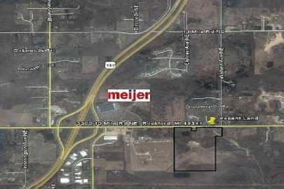
3300 10 Mile Rd Ne, Rockford, MI 49341

NEARBY LISTINGS FOR SALE OR LEASE
-
-
View all Rockford listings for sale on LoopNet.com
Property Detail
3300 10 Mile Rd Ne
41-10-02-100-013
411002100013 PART OF NWFRL 1/4 OF SEC 2 & PART OF NEFRL 1/4 OF SEC 3 COM 201.65 FT S 89D 50M 19S E ALONG N SEC LINE & 60.0 FT
Commercialnec
Kent
X
Michigan
26081C0302D
79.34 AC
2024
Outlying Kent County
2025
West Michigan
011001
Grand Rapids-Wyoming-Kentwood, MI
DEMOGRAPHICS near 3300 10 Mile Rd Ne
1 Mile
3 Mile
5 Mile
2024 Total Population
2,982
22,179
50,979
2029 Population
3,063
22,484
51,636
Pop Growth 2024-2029
+ 2.72%
+ 1.38%
+ 1.29%
Average Age
38
39
40
2024 Total Households
1,112
8,087
18,896
HH Growth 2024-2029
+ 2.70%
+ 1.35%
+ 1.28%
Median Household Inc
$106,416
$100,179
$96,585
Avg Household Size
2.70
2.70
2.70
2024 Avg HH Vehicles
2.00
2.00
2.00
Median Home Value
$296,525
$290,900
$293,868
Median Year Built
2003
1990
1989
Nearby Places
Map Layers
Map Styles
 Street
 Aerial
- Restaurants
- Banks
- Shops
- Fitness
- Groceries
PUBLIC TRANSPORTATION
AIRPORT
Gerald R Ford International
DRIVE
WALK
Distance
Gerald R Ford International
36 min
26.5 mi
Freight Ports
Port Milwaukee
DRIVE
WALK
Distance
Port Milwaukee
320 min
275.4 mi
Nearby Properties
Address
Land Use
TOTAL SIZE
Lot Size
Zoning
Address
Land Use
TOTAL SIZE
Lot Size
Zoning
32.53 AC
Address
Land Use
TOTAL SIZE
Lot Size
Zoning
178,942 SF
143.48 AC
I-1
Address
Land Use
TOTAL SIZE
Lot Size
Zoning
178,942 SF
202.41 AC
I-1
Address
Land Use
TOTAL SIZE
Lot Size
Zoning
22.40 AC
Address
Land Use
TOTAL SIZE
Lot Size
Zoning
128,148 SF
42.93 AC
PUD
Address
Land Use
TOTAL SIZE
Lot Size
Zoning
17.30 AC
Address
Land Use
TOTAL SIZE
Lot Size
Zoning
4.51 AC
Address
Land Use
TOTAL SIZE
Lot Size
Zoning
Address
Land Use
TOTAL SIZE
Lot Size
Zoning
49.13 AC
Address
Land Use
TOTAL SIZE
Lot Size
Zoning
97.71 AC
Address
Land Use
TOTAL SIZE
Lot Size
Zoning
97.84 AC
Address
Land Use
TOTAL SIZE
Lot Size
Zoning
113,165 SF
10.94 AC
R-3
Address
Land Use
TOTAL SIZE
Lot Size
Zoning
74,756 SF
9.86 AC
C-3
Address
Land Use
TOTAL SIZE
Lot Size
Zoning
9.88 AC
Address
Land Use
TOTAL SIZE
Lot Size
Zoning
10.08 AC
Address
Land Use
TOTAL SIZE
Lot Size
Zoning
101,815 SF
9.23 AC
C-3
Address
Land Use
TOTAL SIZE
Lot Size
Zoning
121,183 SF
6.83 AC
I-1
Address
Land Use
TOTAL SIZE
Lot Size
Zoning
11.26 AC
Address
Land Use
TOTAL SIZE
Lot Size
Zoning
8.20 AC
R-3
Address
Land Use
TOTAL SIZE
Lot Size
Zoning
10.12 AC
Address
Land Use
TOTAL SIZE
Lot Size
Zoning
6.51 AC
Address
Land Use
TOTAL SIZE
Lot Size
Zoning
10.61 AC
Address
Land Use
TOTAL SIZE
Lot Size
Zoning
44.69 AC
Address
Land Use
TOTAL SIZE
Lot Size
Zoning
64,075 SF
11.13 AC
I-1
Address
Land Use
TOTAL SIZE
Lot Size
Zoning
18,630 SF
1.84 AC
C2
Address
Land Use
TOTAL SIZE
Lot Size
Zoning
Address
Land Use
TOTAL SIZE
Lot Size
Zoning
1,725 SF
4.90 AC
R-3
Address
Land Use
TOTAL SIZE
Lot Size
Zoning
2.28 AC
Address
Land Use
TOTAL SIZE
Lot Size
Zoning
66,590 SF
4.06 AC
I-1
The World's #1 Commercial Real Estate Marketplace
Connect with us
© 2026 CoStar Group
The information above has been obtained from sources believed reliable. While we do not doubt its accuracy we have not verified it and make no guarantee, warranty or representation about it. It is your responsibility to independently confirm its accuracy and completeness. Any projections, opinions, assumptions, or estimates used are for example only and do not represent the current or future performance of the property. The value of this transaction to you depends on tax and other factors which should be evaluated by your tax, financial, and legal advisors. You and your advisors should conduct a careful, independent investigation of the property to determine to your satisfaction the suitability of the property for your needs.