Property Record
3300 175Th St, Hazel Crest, IL 60429
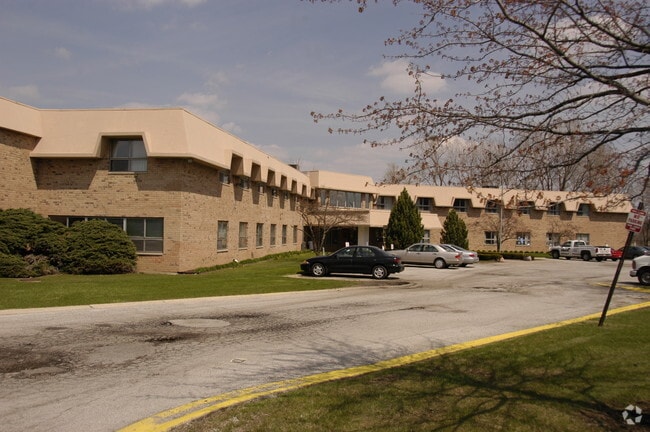

Property Detail
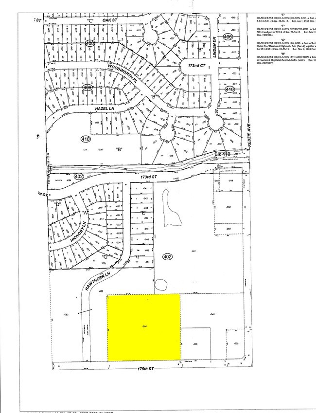
3300 175Th St
28-26-402-004-0000
Cook
Commercialnec
Illinois
B and X Area of moderate flood hazard, usually the area between the limits of the 100-year and 500-year floods.
4.65 AC
2023
Far South
2025
Chicago
825501
Chicago-Naperville-Elgin, IL-IN
62,380 SF
NEARBY LISTINGS FOR SALE OR LEASE
-
-
View all Hazel Crest listings for sale on LoopNet.com
DEMOGRAPHICS near 3300 175Th St
1 mile
3 mile
5 mile
2025 Total Population
13,777
79,615
223,744
2030 Population
13,972
80,800
227,801
Pop Growth 2025-2030
+ 1.42%
+ 1.49%
+ 1.81%
Average Age
40
41
41
2025 Total Households
4,680
28,288
81,237
HH Growth 2025-2030
+ 1.24%
+ 1.28%
+ 1.61%
Median Household Inc
$75,874
$78,083
$74,119
Avg Household Size
2.80
2.70
2.60
2025 Avg HH Vehicles
2.00
2.00
2.00
Median Home Value
$192,415
$205,053
$207,850
Median Year Built
1971
1967
1968
Nearby Places
Map Layers
Map Styles
 Street
 Aerial
Layers
 Traffic
 Biking
Places
Listings with unknown addresses are not visible on the map
- Restaurants
- Banks
- Shops
- Fitness
- Groceries
PUBLIC TRANSPORTATION
COMMUTER RAIL
Calumet Station (Metra Electric Line - Northeast Illinois Regional Commuter Railroad (Metra))
Drive
Walk
Distance
Calumet Station (Metra Electric Line - Northeast Illinois Regional Commuter Railroad (Metra))
4 min
1.9 mi
Homewood Station (Metra Electric Line - Northeast Illinois Regional Commuter Railroad (Metra))
Drive
Walk
Distance
Homewood Station (Metra Electric Line - Northeast Illinois Regional Commuter Railroad (Metra))
6 min
2.4 mi
AIRPORT
Chicago Midway International
Drive
Walk
Distance
Chicago Midway International
29 min
17.0 mi
Chicago O'Hare International
Drive
Walk
Distance
Chicago O'Hare International
72 min
38.8 mi
Nearby Properties
Address
Land Use
TOTAL SIZE
Lot Size
Zoning
Address
Land Use
TOTAL SIZE
Lot Size
Zoning
Address
Land Use
TOTAL SIZE
Lot Size
Zoning
1,033,450 SF
Address
Land Use
TOTAL SIZE
Lot Size
Zoning
Address
Land Use
TOTAL SIZE
Lot Size
Zoning
44,184 SF
5 AC
Address
Land Use
TOTAL SIZE
Lot Size
Zoning
203,995 SF
20.27 AC
Address
Land Use
TOTAL SIZE
Lot Size
Zoning
1,201 SF
3.65 AC
Address
Land Use
TOTAL SIZE
Lot Size
Zoning
196,125 SF
18.55 AC
Address
Land Use
TOTAL SIZE
Lot Size
Zoning
52,220 SF
6 AC
Address
Land Use
TOTAL SIZE
Lot Size
Zoning
3.65 AC
Address
Land Use
TOTAL SIZE
Lot Size
Zoning
27,082 SF
0.69 AC
Address
Land Use
TOTAL SIZE
Lot Size
Zoning
Address
Land Use
TOTAL SIZE
Lot Size
Zoning
49,229 SF
1.31 AC
Address
Land Use
TOTAL SIZE
Lot Size
Zoning
Address
Land Use
TOTAL SIZE
Lot Size
Zoning
85,220 SF
7.10 AC
Address
Land Use
TOTAL SIZE
Lot Size
Zoning
0.34 AC
Address
Land Use
TOTAL SIZE
Lot Size
Zoning
Address
Land Use
TOTAL SIZE
Lot Size
Zoning
48,727 SF
3.76 AC
Address
Land Use
TOTAL SIZE
Lot Size
Zoning
5.42 AC
Address
Land Use
TOTAL SIZE
Lot Size
Zoning
19,858 SF
2.59 AC
Address
Land Use
TOTAL SIZE
Lot Size
Zoning
185,463 SF
10.96 AC
Address
Land Use
TOTAL SIZE
Lot Size
Zoning
Address
Land Use
TOTAL SIZE
Lot Size
Zoning
66,320 SF
12.11 AC
Address
Land Use
TOTAL SIZE
Lot Size
Zoning
90,220 SF
2.21 AC
Address
Land Use
TOTAL SIZE
Lot Size
Zoning
78,075 SF
5.47 AC
Address
Land Use
TOTAL SIZE
Lot Size
Zoning
93,559 SF
9.97 AC
Address
Land Use
TOTAL SIZE
Lot Size
Zoning
11,700 SF
1.35 AC
Address
Land Use
TOTAL SIZE
Lot Size
Zoning
36,920 SF
14.86 AC
Address
Land Use
TOTAL SIZE
Lot Size
Zoning
156,665 SF
3.58 AC
The World's #1 Commercial Real Estate Marketplace
Connect with us
© 2026 CoStar Group
The information above has been obtained from sources believed reliable. While we do not doubt its accuracy we have not verified it and make no guarantee, warranty or representation about it. It is your responsibility to independently confirm its accuracy and completeness. Any projections, opinions, assumptions, or estimates used are for example only and do not represent the current or future performance of the property. The value of this transaction to you depends on tax and other factors which should be evaluated by your tax, financial, and legal advisors. You and your advisors should conduct a careful, independent investigation of the property to determine to your satisfaction the suitability of the property for your needs.