Property Record
3300 Jim Thorpe Hwy, Roxboro, NC 27574
NEARBY LISTINGS FOR SALE OR LEASE
-
-
View all Roxboro listings for sale on LoopNet.com
Property Detail
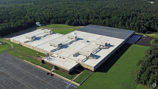
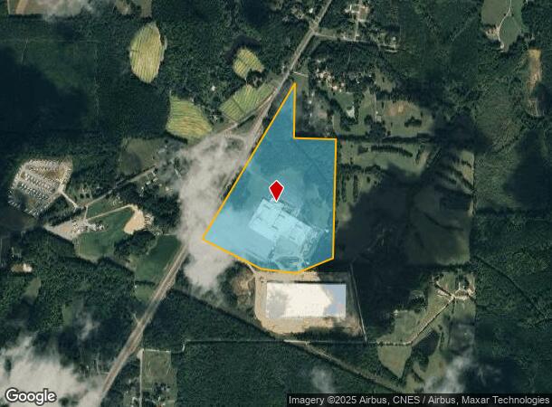
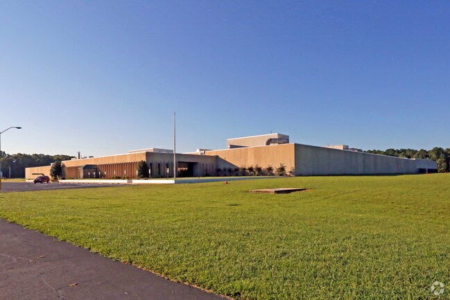
3300 Jim Thorpe Hwy
A69-53
Collins & Aikman Products Co Weave Plant
Industrialgeneral
POLYWOOD/TRACT 1A
X
Person
3720092800J
North Carolina
2025
71.17 AC
2025
Person County
920100
Raleigh/Durham
6,688 SF
Durham-Chapel Hill, NC
DEMOGRAPHICS near 3300 Jim Thorpe Hwy
1 Mile
3 Mile
5 Mile
2024 Total Population
330
4,172
12,274
2029 Population
338
4,291
12,629
Pop Growth 2024-2029
+ 2.42%
+ 2.85%
+ 2.89%
Average Age
45
43
42
2024 Total Households
134
1,700
5,126
HH Growth 2024-2029
+ 2.24%
+ 2.82%
+ 2.89%
Median Household Inc
$60,326
$45,655
$44,258
Avg Household Size
2.40
2.40
2.30
2024 Avg HH Vehicles
2.00
2.00
2.00
Median Home Value
$89,999
$124,785
$135,045
Median Year Built
1981
1977
1976
Nearby Places
Map Layers
Map Styles
 Street
 Aerial
- Restaurants
- Banks
- Shops
- Fitness
- Groceries
SALE & LEASE HISTORY
LISTING DATE
SALE/LEASE

Sep 25, 2016
For Lease
Sep 24, 2016
For Sale
Jan 25, 2017
For Sale
Apr 16, 2018
For Sale
Apr 16, 2018
For Lease
Nearby Properties
Address
Land Use
TOTAL SIZE
Lot Size
Zoning
Address
Land Use
TOTAL SIZE
Lot Size
Zoning
200,964 SF
42.79 AC
Address
Land Use
TOTAL SIZE
Lot Size
Zoning
126,000 SF
32.71 AC
Address
Land Use
TOTAL SIZE
Lot Size
Zoning
236,363 SF
30 AC
Address
Land Use
TOTAL SIZE
Lot Size
Zoning
1,040 SF
26.45 AC
R1
Address
Land Use
TOTAL SIZE
Lot Size
Zoning
181.34 AC
R2
Address
Land Use
TOTAL SIZE
Lot Size
Zoning
12,029 SF
22.40 AC
Address
Land Use
TOTAL SIZE
Lot Size
Zoning
390,070 SF
18.15 AC
Address
Land Use
TOTAL SIZE
Lot Size
Zoning
4,942 SF
1.18 AC
Address
Land Use
TOTAL SIZE
Lot Size
Zoning
132,922 SF
32.89 AC
Address
Land Use
TOTAL SIZE
Lot Size
Zoning
6,517 SF
1.15 AC
Address
Land Use
TOTAL SIZE
Lot Size
Zoning
4,636 SF
64.90 AC
Address
Land Use
TOTAL SIZE
Lot Size
Zoning
11,200 SF
5.65 AC
Address
Land Use
TOTAL SIZE
Lot Size
Zoning
9,100 SF
2.08 AC
Address
Land Use
TOTAL SIZE
Lot Size
Zoning
2,304 SF
3.58 AC
Address
Land Use
TOTAL SIZE
Lot Size
Zoning
10,800 SF
22.98 AC
R2
Address
Land Use
TOTAL SIZE
Lot Size
Zoning
1,700 SF
3.86 AC
Address
Land Use
TOTAL SIZE
Lot Size
Zoning
6,162 SF
20.43 AC
Address
Land Use
TOTAL SIZE
Lot Size
Zoning
3,640 SF
1.32 AC
Address
Land Use
TOTAL SIZE
Lot Size
Zoning
11,560 SF
1.85 AC
Address
Land Use
TOTAL SIZE
Lot Size
Zoning
6,240 SF
3 AC
Address
Land Use
TOTAL SIZE
Lot Size
Zoning
8,400 SF
1.91 AC
R1
Address
Land Use
TOTAL SIZE
Lot Size
Zoning
3,731 SF
2.50 AC
Address
Land Use
TOTAL SIZE
Lot Size
Zoning
2,400 SF
3 AC
Address
Land Use
TOTAL SIZE
Lot Size
Zoning
39,500 SF
10 AC
Address
Land Use
TOTAL SIZE
Lot Size
Zoning
161.49 AC
R2
Address
Land Use
TOTAL SIZE
Lot Size
Zoning
2,410 SF
1.55 AC
Address
Land Use
TOTAL SIZE
Lot Size
Zoning
3,277 SF
1.48 AC
Address
Land Use
TOTAL SIZE
Lot Size
Zoning
95.39 AC
Address
Land Use
TOTAL SIZE
Lot Size
Zoning
3,550 SF
3.70 AC
The World's #1 Commercial Real Estate Marketplace
Connect with us
© 2026 CoStar Group
The information above has been obtained from sources believed reliable. While we do not doubt its accuracy we have not verified it and make no guarantee, warranty or representation about it. It is your responsibility to independently confirm its accuracy and completeness. Any projections, opinions, assumptions, or estimates used are for example only and do not represent the current or future performance of the property. The value of this transaction to you depends on tax and other factors which should be evaluated by your tax, financial, and legal advisors. You and your advisors should conduct a careful, independent investigation of the property to determine to your satisfaction the suitability of the property for your needs.