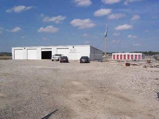
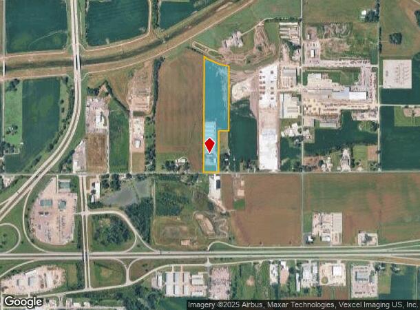
Property Record
3300 Nw 25Th St, Topeka, KS 66618
NEARBY LISTINGS FOR SALE OR LEASE
Property Detail
3300 Nw 25Th St
096-14-0-10-01-005-010
S14, T11, R15, ACRES 16.58, BEG 1150 (S) E OF SW COR NE 1/4 TH W 267.67, N 2075.15, SE 462.56, S 1142.31, W 174, S 751.03 TO POB LESS ROW
Publicstorage
Shawnee
X
Kansas
20177C0202E
16.58 AC
2024
Topeka
2025
Kansas City
003401
Topeka, KS
26,000 SF
DEMOGRAPHICS near 3300 Nw 25Th St
1 Mile
3 Mile
5 Mile
2024 Total Population
443
20,077
72,089
2029 Population
433
19,877
71,679
Pop Growth 2024-2029
(2.26%)
(1.00%)
(0.57%)
Average Age
40
41
40
2024 Total Households
159
8,515
31,069
HH Growth 2024-2029
(2.52%)
(1.03%)
(0.60%)
Median Household Inc
$96,969
$56,201
$49,520
Avg Household Size
2.70
2.20
2.20
2024 Avg HH Vehicles
2.00
2.00
2.00
Median Home Value
$171,323
$137,360
$117,102
Median Year Built
1984
1962
1958
Nearby Places
Map Layers
Map Styles
 Street
 Aerial
- Restaurants
- Banks
- Shops
- Fitness
- Groceries
PUBLIC TRANSPORTATION
COMMUTER RAIL
Topeka Amtrak Station (Southwest Chief - Amtrak)
DRIVE
WALK
Distance
Topeka Amtrak Station (Southwest Chief - Amtrak)
11 min
5.4 mi
Freight Ports
Tulsa Port Of Catoosa
DRIVE
WALK
Distance
Tulsa Port Of Catoosa
283 min
232.9 mi
Nearby Properties
Address
Land Use
TOTAL SIZE
Lot Size
Zoning
Address
Land Use
TOTAL SIZE
Lot Size
Zoning
309,298 SF
7.34 AC
M1
Address
Land Use
TOTAL SIZE
Lot Size
Zoning
90,929 SF
8.68 AC
PUD,OI3,I1
Address
Land Use
TOTAL SIZE
Lot Size
Zoning
94,830 SF
17.09 AC
PUD,M4
Address
Land Use
TOTAL SIZE
Lot Size
Zoning
123,795 SF
16.45 AC
PUD,R1,I1,
Address
Land Use
TOTAL SIZE
Lot Size
Zoning
129,425 SF
96.26 AC
R1
Address
Land Use
TOTAL SIZE
Lot Size
Zoning
22,484 SF
75.33 AC
R1
Address
Land Use
TOTAL SIZE
Lot Size
Zoning
116,026 SF
47.17 AC
R1
Address
Land Use
TOTAL SIZE
Lot Size
Zoning
55,353 SF
12.40 AC
OI2
Address
Land Use
TOTAL SIZE
Lot Size
Zoning
67,302 SF
6.62 AC
OI2,OI3
Address
Land Use
TOTAL SIZE
Lot Size
Zoning
135,164 SF
11.01 AC
PUD,I1
Address
Land Use
TOTAL SIZE
Lot Size
Zoning
39,790 SF
3.76 AC
PUD
Address
Land Use
TOTAL SIZE
Lot Size
Zoning
64,310 SF
12.95 AC
PUD,R1,I1,
Address
Land Use
TOTAL SIZE
Lot Size
Zoning
17,544 SF
42.80 AC
PUD,I1,M2,
Address
Land Use
TOTAL SIZE
Lot Size
Zoning
26,269 SF
8.18 AC
RR1
Address
Land Use
TOTAL SIZE
Lot Size
Zoning
64,318 SF
10.17 AC
RR1
Address
Land Use
TOTAL SIZE
Lot Size
Zoning
16,168 SF
1.62 AC
MS1
Address
Land Use
TOTAL SIZE
Lot Size
Zoning
51,285 SF
36.63 AC
PUD,I1,M2,
Address
Land Use
TOTAL SIZE
Lot Size
Zoning
91,840 SF
13.75 AC
PUD,I1
Address
Land Use
TOTAL SIZE
Lot Size
Zoning
20,304 SF
13.48 AC
RR1
Address
Land Use
TOTAL SIZE
Lot Size
Zoning
26,783 SF
3.11 AC
PUD,I1,M2,
Address
Land Use
TOTAL SIZE
Lot Size
Zoning
50,854 SF
4.42 AC
PUD,R1
Address
Land Use
TOTAL SIZE
Lot Size
Zoning
0.41 AC
OI2
Address
Land Use
TOTAL SIZE
Lot Size
Zoning
421,639 SF
30.15 AC
PUD,I1
Address
Land Use
TOTAL SIZE
Lot Size
Zoning
63,903 SF
5.05 AC
R2
Address
Land Use
TOTAL SIZE
Lot Size
Zoning
67,997 SF
7.83 AC
PUD
Address
Land Use
TOTAL SIZE
Lot Size
Zoning
45,231 SF
11.95 AC
OI2
Address
Land Use
TOTAL SIZE
Lot Size
Zoning
35,713 SF
4.03 AC
OI2
Address
Land Use
TOTAL SIZE
Lot Size
Zoning
244,943 SF
75.15 AC
PUD,I1
Address
Land Use
TOTAL SIZE
Lot Size
Zoning
72,295 SF
13.39 AC
R1
Address
Land Use
TOTAL SIZE
Lot Size
Zoning
0.26 AC
OI2
The World's #1 Commercial Real Estate Marketplace
Connect with us
© 2025 CoStar Group
The information above has been obtained from sources believed reliable. While we do not doubt its accuracy we have not verified it and make no guarantee, warranty or representation about it. It is your responsibility to independently confirm its accuracy and completeness. Any projections, opinions, assumptions, or estimates used are for example only and do not represent the current or future performance of the property. The value of this transaction to you depends on tax and other factors which should be evaluated by your tax, financial, and legal advisors. You and your advisors should conduct a careful, independent investigation of the property to determine to your satisfaction the suitability of the property for your needs.