Property Record
3300 Spirea Ct, Jackson, MI 49202
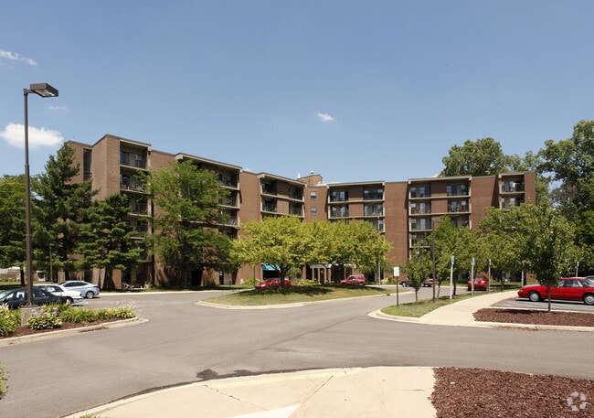


Property Detail
3300 Spirea Ct
000-08-20-376-001-00
BEG AT THE INTERSECTION OF THE CEN LN OF SPRINGPORT RD WITH THE CEN LN OF COUNTY FARM RD TH N 88 DEG 31'17''W 1130 FT ALG THE S LN OF SEC 20 TH N 1 DEG 28'43''E 850 FT TH N 73 DEG 28'43''E 742.9 FT TO THE CEN OF SPRINGPORT RD TH ALG CEN OF SD RD, SEL
Apartment
Jackson
PR-1
Michigan
B and X Area of moderate flood hazard, usually the area between the limits of the 100-year and 500-year floods.
21.68 AC
2025
Jackson County
2025
West Michigan
005601
Jackson, MI
110,894 SF
NEARBY LISTINGS FOR SALE OR LEASE
DEMOGRAPHICS near 3300 Spirea Ct
1 mile
3 mile
5 mile
2025 Total Population
5,245
29,475
65,608
2030 Population
5,263
29,378
65,361
Pop Growth 2025-2030
+ 0.34%
(0.33%)
(0.38%)
Average Age
40
40
40
2025 Total Households
2,867
12,999
27,672
HH Growth 2025-2030
+ 0.45%
(0.27%)
(0.38%)
Median Household Inc
$43,993
$50,032
$51,386
Avg Household Size
1.80
2.20
2.30
2025 Avg HH Vehicles
1.00
2.00
2.00
Median Home Value
$144,354
$163,214
$153,427
Median Year Built
1980
1962
1958
Nearby Places
Map Layers
Map Styles
 Street
 Aerial
Layers
 Traffic
 Biking
Places
Listings with unknown addresses are not visible on the map
- Restaurants
- Banks
- Shops
- Fitness
- Groceries
PUBLIC TRANSPORTATION
COMMUTER RAIL
Drive
Walk
Distance
9 min
4.5 mi
AIRPORT
Capital Region International
Drive
Walk
Distance
Capital Region International
51 min
40.7 mi
Nearby Properties
Address
Land Use
TOTAL SIZE
Lot Size
Zoning
Address
Land Use
TOTAL SIZE
Lot Size
Zoning
121,532 SF
29.94 AC
PC-1
Address
Land Use
TOTAL SIZE
Lot Size
Zoning
398,449 SF
41.51 AC
PR-1
Address
Land Use
TOTAL SIZE
Lot Size
Zoning
240,148 SF
30.64 AC
PC-1
Address
Land Use
TOTAL SIZE
Lot Size
Zoning
415,004 SF
19.97 AC
PB
Address
Land Use
TOTAL SIZE
Lot Size
Zoning
224,803 SF
22.59 AC
RM-1
Address
Land Use
TOTAL SIZE
Lot Size
Zoning
217,115 SF
92.26 AC
I-1
Address
Land Use
TOTAL SIZE
Lot Size
Zoning
187,264 SF
7.10 AC
R-4
Address
Land Use
TOTAL SIZE
Lot Size
Zoning
251,350 SF
23.11 AC
I-1
Address
Land Use
TOTAL SIZE
Lot Size
Zoning
189,680 SF
6.90 AC
R-4
Address
Land Use
TOTAL SIZE
Lot Size
Zoning
302,225 SF
55.18 AC
I-2
Address
Land Use
TOTAL SIZE
Lot Size
Zoning
123,770 SF
I-2
Address
Land Use
TOTAL SIZE
Lot Size
Zoning
202,757 SF
13 AC
PC-1
Address
Land Use
TOTAL SIZE
Lot Size
Zoning
84,489 SF
55.50 AC
RM-1
Address
Land Use
TOTAL SIZE
Lot Size
Zoning
125,393 SF
3.94 AC
C-2
Address
Land Use
TOTAL SIZE
Lot Size
Zoning
91,108 SF
5.42 AC
C-2
Address
Land Use
TOTAL SIZE
Lot Size
Zoning
145,152 SF
41.45 AC
RM-1
Address
Land Use
TOTAL SIZE
Lot Size
Zoning
84,084 SF
6.50 AC
PB
Address
Land Use
TOTAL SIZE
Lot Size
Zoning
242,708 SF
29.44 AC
PC-1
Address
Land Use
TOTAL SIZE
Lot Size
Zoning
207,420 SF
15.10 AC
RM-1
Address
Land Use
TOTAL SIZE
Lot Size
Zoning
217,324 SF
40.24 AC
I-2
Address
Land Use
TOTAL SIZE
Lot Size
Zoning
112,571 SF
9.35 AC
C-4
Address
Land Use
TOTAL SIZE
Lot Size
Zoning
137,313 SF
23.30 AC
C-3
Address
Land Use
TOTAL SIZE
Lot Size
Zoning
159,432 SF
31.90 AC
RM-1
Address
Land Use
TOTAL SIZE
Lot Size
Zoning
180,410 SF
12.60 AC
RM-1
Address
Land Use
TOTAL SIZE
Lot Size
Zoning
35,908 SF
6.60 AC
R-4
Address
Land Use
TOTAL SIZE
Lot Size
Zoning
98,560 SF
13.35 AC
RM-1
Address
Land Use
TOTAL SIZE
Lot Size
Zoning
79,923 SF
8.17 AC
C-2
Address
Land Use
TOTAL SIZE
Lot Size
Zoning
54,672 SF
5.93 AC
C-2
Address
Land Use
TOTAL SIZE
Lot Size
Zoning
270,966 SF
67.93 AC
I-1
The World's #1 Commercial Real Estate Marketplace
Connect with us
© 2026 CoStar Group
The information above has been obtained from sources believed reliable. While we do not doubt its accuracy we have not verified it and make no guarantee, warranty or representation about it. It is your responsibility to independently confirm its accuracy and completeness. Any projections, opinions, assumptions, or estimates used are for example only and do not represent the current or future performance of the property. The value of this transaction to you depends on tax and other factors which should be evaluated by your tax, financial, and legal advisors. You and your advisors should conduct a careful, independent investigation of the property to determine to your satisfaction the suitability of the property for your needs.