Property Record
3301 E Harry St, Wichita, KS 67218
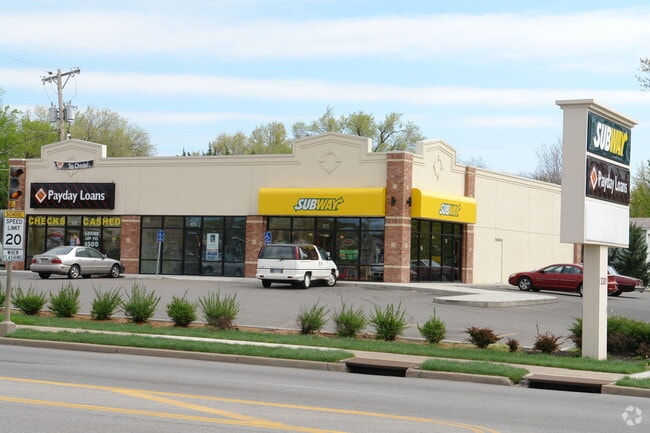
This Property Is For Sale
Current Lease Availabilities
NEARBY LISTINGS FOR SALE OR LEASE
Property Detail
3301 E Harry St
Wichita, KS
Pankratz Add
127-35-0-22-01-001.00B
LOT 2 BLOCK B PANKRATZ ADD.
Storebuilding
Sedgwick
X
Kansas
20173C0366G
2
2024
0.16 AC
2025
Southeast
006300
Wichita
5,600 SF
DEMOGRAPHICS near 3301 E Harry St
1 Mile
3 Mile
5 Mile
2024 Total Population
14,232
99,308
232,894
2029 Population
14,719
102,643
239,415
Pop Growth 2024-2029
+ 3.42%
+ 3.36%
+ 2.80%
Average Age
39
37
37
2024 Total Households
5,894
40,880
94,856
HH Growth 2024-2029
+ 3.48%
+ 3.35%
+ 2.79%
Median Household Inc
$42,740
$43,080
$45,312
Avg Household Size
2.30
2.30
2.30
2024 Avg HH Vehicles
2.00
2.00
2.00
Median Home Value
$81,390
$90,453
$110,525
Median Year Built
1954
1954
1960
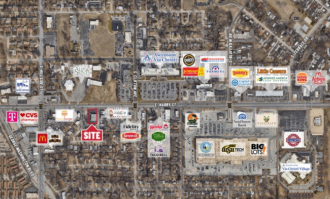
Nearby Places
Map Layers
Map Styles
 Street
 Aerial
- Restaurants
- Banks
- Shops
- Fitness
- Groceries
PUBLIC TRANSPORTATION
AIRPORT
Wichita Dwight D Eisenhower Ntl
DRIVE
WALK
Distance
Wichita Dwight D Eisenhower Ntl
16 min
9.8 mi
Freight Ports
Tulsa Port Of Catoosa
DRIVE
WALK
Distance
Tulsa Port Of Catoosa
204 min
191.7 mi
Nearby Properties
Address
Land Use
TOTAL SIZE
Lot Size
Zoning
Address
Land Use
TOTAL SIZE
Lot Size
Zoning
468,755 SF
10.41 AC
CBD,LI
Address
Land Use
TOTAL SIZE
Lot Size
Zoning
515,640 SF
14.49 AC
CBD
Address
Land Use
TOTAL SIZE
Lot Size
Zoning
154,716 SF
12.18 AC
LC
Address
Land Use
TOTAL SIZE
Lot Size
Zoning
430,593 SF
11.89 AC
GO,LC
Address
Land Use
TOTAL SIZE
Lot Size
Zoning
576,707 SF
53.70 AC
B,LC
Address
Land Use
TOTAL SIZE
Lot Size
Zoning
271,541 SF
39.20 AC
GO
Address
Land Use
TOTAL SIZE
Lot Size
Zoning
237,087 SF
48.33 AC
B
Address
Land Use
TOTAL SIZE
Lot Size
Zoning
418.47 AC
AFB
Address
Land Use
TOTAL SIZE
Lot Size
Zoning
197,464 SF
4.05 AC
CBD
Address
Land Use
TOTAL SIZE
Lot Size
Zoning
527,510 SF
50.27 AC
TF-3
Address
Land Use
TOTAL SIZE
Lot Size
Zoning
225,962 SF
0.24 AC
CBD
Address
Land Use
TOTAL SIZE
Lot Size
Zoning
328,487 SF
25.95 AC
MF-29
Address
Land Use
TOTAL SIZE
Lot Size
Zoning
167,304 SF
6.19 AC
MF-29
Address
Land Use
TOTAL SIZE
Lot Size
Zoning
110,839 SF
0.81 AC
CBD
Address
Land Use
TOTAL SIZE
Lot Size
Zoning
152,978 SF
7.86 AC
LI
Address
Land Use
TOTAL SIZE
Lot Size
Zoning
945,203 SF
9.53 AC
GO
Address
Land Use
TOTAL SIZE
Lot Size
Zoning
108,232 SF
3.72 AC
PUD
Address
Land Use
TOTAL SIZE
Lot Size
Zoning
167,315 SF
2 AC
LC,SF-5
Address
Land Use
TOTAL SIZE
Lot Size
Zoning
728,346 SF
33.17 AC
LC
Address
Land Use
TOTAL SIZE
Lot Size
Zoning
84,788 SF
5.98 AC
PUD
Address
Land Use
TOTAL SIZE
Lot Size
Zoning
81,870 SF
3.70 AC
B,GC
Address
Land Use
TOTAL SIZE
Lot Size
Zoning
103,218 SF
1.03 AC
CBD
Address
Land Use
TOTAL SIZE
Lot Size
Zoning
87,108 SF
4.09 AC
LC,SF-5
Address
Land Use
TOTAL SIZE
Lot Size
Zoning
134,475 SF
19.87 AC
LI
Address
Land Use
TOTAL SIZE
Lot Size
Zoning
106,159 SF
16.16 AC
SF-5
Address
Land Use
TOTAL SIZE
Lot Size
Zoning
112,088 SF
4.05 AC
SF-5,B
Address
Land Use
TOTAL SIZE
Lot Size
Zoning
71,568 SF
4.83 AC
TF-3
Address
Land Use
TOTAL SIZE
Lot Size
Zoning
153,829 SF
0.86 AC
CBD
Address
Land Use
TOTAL SIZE
Lot Size
Zoning
59,837 SF
3.72 AC
TF-3
The World's #1 Commercial Real Estate Marketplace
Connect with us
© 2025 CoStar Group
The information above has been obtained from sources believed reliable. While we do not doubt its accuracy we have not verified it and make no guarantee, warranty or representation about it. It is your responsibility to independently confirm its accuracy and completeness. Any projections, opinions, assumptions, or estimates used are for example only and do not represent the current or future performance of the property. The value of this transaction to you depends on tax and other factors which should be evaluated by your tax, financial, and legal advisors. You and your advisors should conduct a careful, independent investigation of the property to determine to your satisfaction the suitability of the property for your needs.