Property Record
3301 E Main Rd, Dunkirk, NY 14048
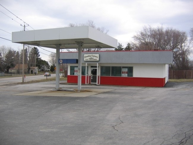

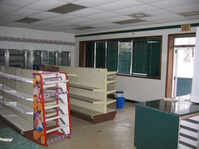

Property Detail
3301 E Main Rd
066400-097-000-0002-020-000
OLD APN: 066400 9-2-1.2
Servicestationmarket
CHAUTAUQUA
07 - MIXED
New York
2025
20.000
2025
0.60 AC
035300
Other Market Areas
1,352 SF
Jamestown-Dunkirk, NY
NEARBY LISTINGS FOR SALE OR LEASE
DEMOGRAPHICS near 3301 E Main Rd
1 mile
3 mile
5 mile
2025 Total Population
329
9,263
27,521
2030 Population
314
8,819
27,347
Pop Growth 2025-2030
(4.56%)
(4.79%)
(0.63%)
Average Age
46
42
41
2025 Total Households
136
3,966
11,449
HH Growth 2025-2030
(5.15%)
(5.07%)
(0.58%)
Median Household Inc
$88,020
$52,544
$53,694
Avg Household Size
2.40
2.20
2.20
2025 Avg HH Vehicles
2.00
1.00
2.00
Median Home Value
$181,999
$109,835
$132,831
Median Year Built
1957
1951
1955
Nearby Places
Map Layers
Map Styles
 Street
 Aerial
Layers
 Traffic
 Biking
Places
Listings with unknown addresses are not visible on the map
- Restaurants
- Banks
- Shops
- Fitness
- Groceries
Nearby Properties
Address
Land Use
TOTAL SIZE
Lot Size
Zoning
Address
Land Use
TOTAL SIZE
Lot Size
Zoning
163,219 SF
6.50 AC
M2
Address
Land Use
TOTAL SIZE
Lot Size
Zoning
1,300 SF
16 AC
M1
Address
Land Use
TOTAL SIZE
Lot Size
Zoning
542,989 SF
47.40 AC
L1
Address
Land Use
TOTAL SIZE
Lot Size
Zoning
15,244 SF
19.36 AC
M2
Address
Land Use
TOTAL SIZE
Lot Size
Zoning
113,097 SF
8.20 AC
HC
Address
Land Use
TOTAL SIZE
Lot Size
Zoning
31.20 AC
C1
Address
Land Use
TOTAL SIZE
Lot Size
Zoning
93,000 SF
14 AC
Address
Land Use
TOTAL SIZE
Lot Size
Zoning
90,660 SF
5.30 AC
HC
Address
Land Use
TOTAL SIZE
Lot Size
Zoning
21,000 SF
11.70 AC
HC
Address
Land Use
TOTAL SIZE
Lot Size
Zoning
143,375 SF
24.70 AC
C2
Address
Land Use
TOTAL SIZE
Lot Size
Zoning
228,261 SF
10.50 AC
L1
Address
Land Use
TOTAL SIZE
Lot Size
Zoning
29.90 AC
07 - MIXED
Address
Land Use
TOTAL SIZE
Lot Size
Zoning
21.70 AC
07 - MIXED
Address
Land Use
TOTAL SIZE
Lot Size
Zoning
4,988 SF
12.90 AC
R1
Address
Land Use
TOTAL SIZE
Lot Size
Zoning
33,826 SF
3.10 AC
R3
Address
Land Use
TOTAL SIZE
Lot Size
Zoning
30,882 SF
10.58 AC
M2
Address
Land Use
TOTAL SIZE
Lot Size
Zoning
31,715 SF
3.20 AC
CR
Address
Land Use
TOTAL SIZE
Lot Size
Zoning
20.60 AC
CR
Address
Land Use
TOTAL SIZE
Lot Size
Zoning
18,914 SF
7.35 AC
M2
Address
Land Use
TOTAL SIZE
Lot Size
Zoning
190,873 SF
21.50 AC
V1
Address
Land Use
TOTAL SIZE
Lot Size
Zoning
1.70 AC
Address
Land Use
TOTAL SIZE
Lot Size
Zoning
23,810 SF
256.60 AC
07 - MIXED
Address
Land Use
TOTAL SIZE
Lot Size
Zoning
65,201 SF
7.20 AC
HC
Address
Land Use
TOTAL SIZE
Lot Size
Zoning
121,500 SF
9.30 AC
06 - INDUS
Address
Land Use
TOTAL SIZE
Lot Size
Zoning
27,238 SF
1.60 AC
C1
Address
Land Use
TOTAL SIZE
Lot Size
Zoning
30,205 SF
4.18 AC
R3
Address
Land Use
TOTAL SIZE
Lot Size
Zoning
29,747 SF
3.90 AC
CR
Address
Land Use
TOTAL SIZE
Lot Size
Zoning
9,408 SF
4.67 AC
R1
Address
Land Use
TOTAL SIZE
Lot Size
Zoning
32,467 SF
1.16 AC
R2
Address
Land Use
TOTAL SIZE
Lot Size
Zoning
164,015 SF
9.10 AC
M2
The World's #1 Commercial Real Estate Marketplace
Connect with us
© 2026 CoStar Group
The information above has been obtained from sources believed reliable. While we do not doubt its accuracy we have not verified it and make no guarantee, warranty or representation about it. It is your responsibility to independently confirm its accuracy and completeness. Any projections, opinions, assumptions, or estimates used are for example only and do not represent the current or future performance of the property. The value of this transaction to you depends on tax and other factors which should be evaluated by your tax, financial, and legal advisors. You and your advisors should conduct a careful, independent investigation of the property to determine to your satisfaction the suitability of the property for your needs.