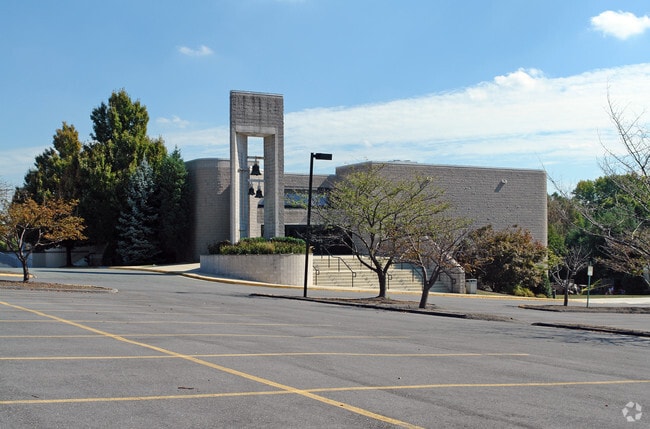
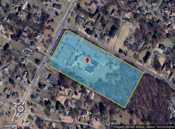
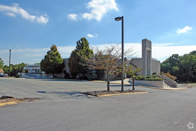
Property Record
3301 Greencastle Rd, Burtonsville, MD 20866
NEARBY LISTINGS FOR SALE OR LEASE
-
-
View all Burtonsville listings for sale on LoopNet.com
Property Detail
3301 Greencastle Rd
Washington-Arlington-Alexandria, DC-VA-MD-WV
Perrywood Est
05-02549175
PLAT 15655 PERRYWOOD ESTATES
Religious
Montgomery
X
Maryland
24033C0030E
10
2024
9.24 AC
2025
North Silver Spring/Rt 29
701426
Washington, DC
25,561 SF
DEMOGRAPHICS near 3301 Greencastle Rd
1 Mile
3 Mile
5 Mile
2024 Total Population
14,750
65,664
187,266
2029 Population
14,532
64,888
184,912
Pop Growth 2024-2029
(1.48%)
(1.18%)
(1.26%)
Average Age
38
41
41
2024 Total Households
4,858
22,694
65,633
HH Growth 2024-2029
(1.69%)
(1.03%)
(1.38%)
Median Household Inc
$99,999
$103,614
$103,136
Avg Household Size
3.00
2.80
2.80
2024 Avg HH Vehicles
2.00
2.00
2.00
Median Home Value
$397,218
$458,931
$470,486
Median Year Built
1983
1983
1983
Nearby Places
Map Layers
Map Styles
 Street
 Aerial
- Restaurants
- Banks
- Shops
- Fitness
- Groceries
PUBLIC TRANSPORTATION
COMMUTER RAIL
Laurel (CAMDEN - WASHINGTON - Maryland Area Regional Commuter Trains (The MARC), Camden Line - Maryland Area Regional Commuter Trains (The MARC))
DRIVE
WALK
Distance
Laurel (CAMDEN - WASHINGTON - Maryland Area Regional Commuter Trains (The MARC), Camden Line - Maryland Area Regional Commuter Trains (The MARC))
13 min
7.0 mi
Muirkirk (CAMDEN - WASHINGTON - Maryland Area Regional Commuter Trains (The MARC), Camden Line - Maryland Area Regional Commuter Trains (The MARC))
DRIVE
WALK
Distance
Muirkirk (CAMDEN - WASHINGTON - Maryland Area Regional Commuter Trains (The MARC), Camden Line - Maryland Area Regional Commuter Trains (The MARC))
10 min
7.1 mi
AIRPORT
Ronald Reagan Washington Ntl
DRIVE
WALK
Distance
Ronald Reagan Washington Ntl
36 min
20.8 mi
Baltimore/Washington International Thurgood Marshall
DRIVE
WALK
Distance
Baltimore/Washington International Thurgood Marshall
32 min
22.8 mi
Washington Dulles International
DRIVE
WALK
Distance
Washington Dulles International
57 min
37.0 mi
Freight Ports
Port of Baltimore
DRIVE
WALK
Distance
Port of Baltimore
36 min
25.7 mi
Nearby Properties
Address
Land Use
TOTAL SIZE
Lot Size
Zoning
Address
Land Use
TOTAL SIZE
Lot Size
Zoning
218,406 SF
26.80 AC
LAUR
Address
Land Use
TOTAL SIZE
Lot Size
Zoning
66,150 SF
6.79 AC
CRF
Address
Land Use
TOTAL SIZE
Lot Size
Zoning
531,312 SF
25.70 AC
R30
Address
Land Use
TOTAL SIZE
Lot Size
Zoning
559,944 SF
11.89 AC
IE
Address
Land Use
TOTAL SIZE
Lot Size
Zoning
482,799 SF
17.79 AC
R30
Address
Land Use
TOTAL SIZE
Lot Size
Zoning
166,410 SF
26.25 AC
CRT1.
Address
Land Use
TOTAL SIZE
Lot Size
Zoning
310,052 SF
9.63 AC
R20
Address
Land Use
TOTAL SIZE
Lot Size
Zoning
371,939 SF
21.54 AC
EOF1.
Address
Land Use
TOTAL SIZE
Lot Size
Zoning
222,345 SF
14.21 AC
R30
Address
Land Use
TOTAL SIZE
Lot Size
Zoning
235,616 SF
12.81 AC
R30
Address
Land Use
TOTAL SIZE
Lot Size
Zoning
4,380 SF
17.89 AC
CRT22
Address
Land Use
TOTAL SIZE
Lot Size
Zoning
92,294 SF
3.22 AC
CR0.7
Address
Land Use
TOTAL SIZE
Lot Size
Zoning
350,684 SF
36.50 AC
EOF1.
Address
Land Use
TOTAL SIZE
Lot Size
Zoning
456,896 SF
8.96 AC
R20
Address
Land Use
TOTAL SIZE
Lot Size
Zoning
239,072 SF
10.41 AC
R20
Address
Land Use
TOTAL SIZE
Lot Size
Zoning
177,712 SF
13.89 AC
GR1.5
Address
Land Use
TOTAL SIZE
Lot Size
Zoning
362,438 SF
39.95 AC
IE
Address
Land Use
TOTAL SIZE
Lot Size
Zoning
154,775 SF
33.38 AC
R200
Address
Land Use
TOTAL SIZE
Lot Size
Zoning
195,369 SF
9.72 AC
R20
Address
Land Use
TOTAL SIZE
Lot Size
Zoning
202,191 SF
7.70 AC
R30
Address
Land Use
TOTAL SIZE
Lot Size
Zoning
19.17 AC
IE
Address
Land Use
TOTAL SIZE
Lot Size
Zoning
242,468 SF
17.77 AC
R30
Address
Land Use
TOTAL SIZE
Lot Size
Zoning
115,000 SF
10.14 AC
RE1
Address
Land Use
TOTAL SIZE
Lot Size
Zoning
141,492 SF
7.96 AC
R20
Address
Land Use
TOTAL SIZE
Lot Size
Zoning
127,803 SF
2.91 AC
EOF07
Address
Land Use
TOTAL SIZE
Lot Size
Zoning
94,545 SF
30.85 AC
RC
Address
Land Use
TOTAL SIZE
Lot Size
Zoning
57,749 SF
4.98 AC
GR1.5
Address
Land Use
TOTAL SIZE
Lot Size
Zoning
92,227 SF
6.51 AC
R200
Address
Land Use
TOTAL SIZE
Lot Size
Zoning
95,600 SF
3.91 AC
IM2.5
Address
Land Use
TOTAL SIZE
Lot Size
Zoning
150,020 SF
19.11 AC
IE
The World's #1 Commercial Real Estate Marketplace
Connect with us
© 2025 CoStar Group
The information above has been obtained from sources believed reliable. While we do not doubt its accuracy we have not verified it and make no guarantee, warranty or representation about it. It is your responsibility to independently confirm its accuracy and completeness. Any projections, opinions, assumptions, or estimates used are for example only and do not represent the current or future performance of the property. The value of this transaction to you depends on tax and other factors which should be evaluated by your tax, financial, and legal advisors. You and your advisors should conduct a careful, independent investigation of the property to determine to your satisfaction the suitability of the property for your needs.