Property Record
3301 N Highway 6, Woodway, TX 76712
NEARBY LISTINGS FOR SALE OR LEASE
-
-
View all Woodway listings for sale on LoopNet.com
Property Detail
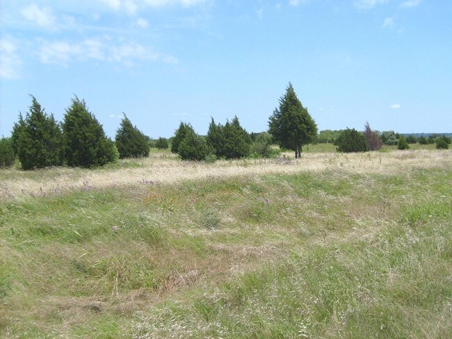
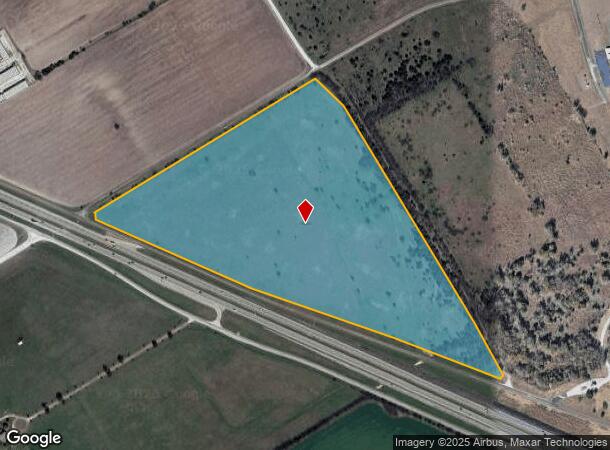
3301 N Highway 6
Waco, TX
Jones H W
36-048900-001300-7
JONES H W ACRES 51.92
Miscellaneous
Mclennan
AE
Texas
48309C0345C
51.92 AC
2024
Waco & Killeen
2025
Other Market Areas
002504
DEMOGRAPHICS near 3301 N Highway 6
1 Mile
3 Mile
5 Mile
2024 Total Population
15
14,332
66,240
2029 Population
15
15,203
70,025
Pop Growth 2024-2029
0.00%
+ 6.08%
+ 5.71%
Average Age
40
43
40
2024 Total Households
6
5,692
26,140
HH Growth 2024-2029
0.00%
+ 6.25%
+ 5.87%
Median Household Inc
$59,999
$84,322
$64,443
Avg Household Size
2.20
2.40
2.40
2024 Avg HH Vehicles
2.00
2.00
2.00
Median Home Value
$199,999
$268,352
$237,243
Median Year Built
1984
1972
1974
Nearby Places
Map Layers
Map Styles
 Street
 Aerial
- Restaurants
- Banks
- Shops
- Fitness
- Groceries
PUBLIC TRANSPORTATION
AIRPORT
Waco Regional
DRIVE
WALK
Distance
Waco Regional
21 min
12.6 mi
Freight Ports
Port of Houston
DRIVE
WALK
Distance
Port of Houston
224 min
195.9 mi
Nearby Properties
Address
Land Use
TOTAL SIZE
Lot Size
Zoning
Address
Land Use
TOTAL SIZE
Lot Size
Zoning
106.92 AC
Address
Land Use
TOTAL SIZE
Lot Size
Zoning
10,334 SF
29.45 AC
R1B
Address
Land Use
TOTAL SIZE
Lot Size
Zoning
211,432 SF
13.86 AC
O2
Address
Land Use
TOTAL SIZE
Lot Size
Zoning
223,307 SF
27.28 AC
O-2,
Address
Land Use
TOTAL SIZE
Lot Size
Zoning
80,890 SF
13.08 AC
O1
Address
Land Use
TOTAL SIZE
Lot Size
Zoning
31,342 SF
7.52 AC
C1
Address
Land Use
TOTAL SIZE
Lot Size
Zoning
67,227 SF
8.62 AC
R1B
Address
Land Use
TOTAL SIZE
Lot Size
Zoning
54,466 SF
73.24 AC
O2
Address
Land Use
TOTAL SIZE
Lot Size
Zoning
102,149 SF
7.99 AC
O2
Address
Land Use
TOTAL SIZE
Lot Size
Zoning
20,258 SF
6.98 AC
C-2
Address
Land Use
TOTAL SIZE
Lot Size
Zoning
54,901 SF
6.49 AC
Address
Land Use
TOTAL SIZE
Lot Size
Zoning
34,753 SF
11.06 AC
R1A
Address
Land Use
TOTAL SIZE
Lot Size
Zoning
45,085 SF
4.61 AC
C-2
Address
Land Use
TOTAL SIZE
Lot Size
Zoning
22,111 SF
6.63 AC
O-1
Address
Land Use
TOTAL SIZE
Lot Size
Zoning
17,004 SF
5.71 AC
Address
Land Use
TOTAL SIZE
Lot Size
Zoning
33,410 SF
6.30 AC
C-3
Address
Land Use
TOTAL SIZE
Lot Size
Zoning
50,025 SF
2.54 AC
Address
Land Use
TOTAL SIZE
Lot Size
Zoning
49,439 SF
3.75 AC
Address
Land Use
TOTAL SIZE
Lot Size
Zoning
19,418 SF
3.40 AC
R1B
Address
Land Use
TOTAL SIZE
Lot Size
Zoning
79,996 SF
6.86 AC
Address
Land Use
TOTAL SIZE
Lot Size
Zoning
128,760 SF
14.35 AC
C-2,
Address
Land Use
TOTAL SIZE
Lot Size
Zoning
22,133 SF
2.65 AC
O1
Address
Land Use
TOTAL SIZE
Lot Size
Zoning
51,467 SF
13.29 AC
R1B
Address
Land Use
TOTAL SIZE
Lot Size
Zoning
32,614 SF
5.17 AC
O2
Address
Land Use
TOTAL SIZE
Lot Size
Zoning
16,498 SF
6.44 AC
C-2
Address
Land Use
TOTAL SIZE
Lot Size
Zoning
40,000 SF
4.06 AC
Address
Land Use
TOTAL SIZE
Lot Size
Zoning
22,345 SF
1.10 AC
O3
Address
Land Use
TOTAL SIZE
Lot Size
Zoning
28.12 AC
O2
Address
Land Use
TOTAL SIZE
Lot Size
Zoning
44,406 SF
6.67 AC
Address
Land Use
TOTAL SIZE
Lot Size
Zoning
43,048 SF
2.12 AC
R3D
The World's #1 Commercial Real Estate Marketplace
Connect with us
© 2025 CoStar Group
The information above has been obtained from sources believed reliable. While we do not doubt its accuracy we have not verified it and make no guarantee, warranty or representation about it. It is your responsibility to independently confirm its accuracy and completeness. Any projections, opinions, assumptions, or estimates used are for example only and do not represent the current or future performance of the property. The value of this transaction to you depends on tax and other factors which should be evaluated by your tax, financial, and legal advisors. You and your advisors should conduct a careful, independent investigation of the property to determine to your satisfaction the suitability of the property for your needs.