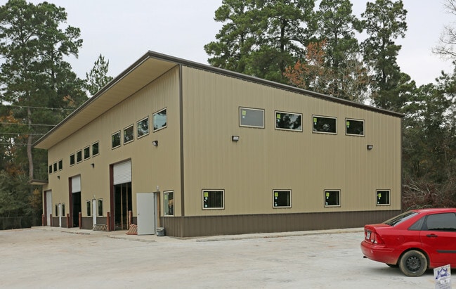
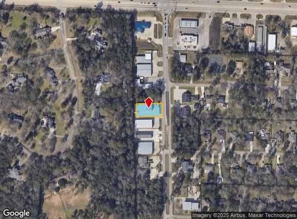
Property Record
33015 Tamina Rd, Magnolia, TX 77354
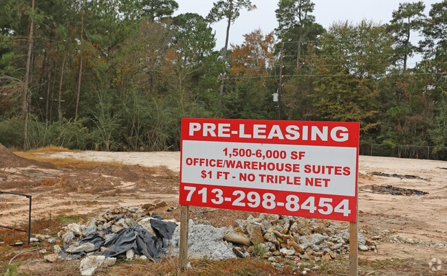
Current Lease Availabilities
NEARBY LISTINGS FOR SALE OR LEASE
Property Detail
33015 Tamina Rd
Houston-Pasadena-The Woodlands, TX
Westwood 02
9495-02-00600
S949502 - WESTWOOD 02, BLOCK 1, LOT 6
Commercialnec
Montgomery
X
Texas
48339C0505G
6
2024
0.37 AC
2025
The Woodlands/Conroe
690406
Houston
7,808 SF
DEMOGRAPHICS near 33015 Tamina Rd
1 Mile
3 Mile
5 Mile
2024 Total Population
5,489
44,202
102,923
2029 Population
6,771
53,936
125,626
Pop Growth 2024-2029
+ 23.36%
+ 22.02%
+ 22.06%
Average Age
37
38
39
2024 Total Households
1,815
15,048
35,295
HH Growth 2024-2029
+ 23.47%
+ 22.27%
+ 22.26%
Median Household Inc
$122,483
$131,258
$131,385
Avg Household Size
3.00
2.90
2.90
2024 Avg HH Vehicles
2.00
2.00
2.00
Median Home Value
$272,263
$419,538
$407,510
Median Year Built
2007
2005
2005
Nearby Places
Map Layers
Map Styles
 Street
 Aerial
- Restaurants
- Banks
- Shops
- Fitness
- Groceries
PUBLIC TRANSPORTATION
AIRPORT
George Bush Intcntl/Houston
DRIVE
WALK
Distance
George Bush Intcntl/Houston
44 min
33.8 mi
Freight Ports
Port of Houston
DRIVE
WALK
Distance
Port of Houston
67 min
49.5 mi
Nearby Properties
Address
Land Use
TOTAL SIZE
Lot Size
Zoning
Address
Land Use
TOTAL SIZE
Lot Size
Zoning
461,345 SF
28.36 AC
Address
Land Use
TOTAL SIZE
Lot Size
Zoning
370,029 SF
16.12 AC
Address
Land Use
TOTAL SIZE
Lot Size
Zoning
392,613 SF
19.35 AC
2
Address
Land Use
TOTAL SIZE
Lot Size
Zoning
361,747 SF
16.71 AC
Address
Land Use
TOTAL SIZE
Lot Size
Zoning
367,449 SF
7.78 AC
Address
Land Use
TOTAL SIZE
Lot Size
Zoning
296,538 SF
12.58 AC
Address
Land Use
TOTAL SIZE
Lot Size
Zoning
426,425 SF
8.74 AC
Address
Land Use
TOTAL SIZE
Lot Size
Zoning
194,272 SF
11.06 AC
Address
Land Use
TOTAL SIZE
Lot Size
Zoning
203,460 SF
39.49 AC
2
Address
Land Use
TOTAL SIZE
Lot Size
Zoning
222,687 SF
8.03 AC
2
Address
Land Use
TOTAL SIZE
Lot Size
Zoning
198,969 SF
32.78 AC
Address
Land Use
TOTAL SIZE
Lot Size
Zoning
190,824 SF
3.62 AC
Address
Land Use
TOTAL SIZE
Lot Size
Zoning
107,000 SF
4.81 AC
Address
Land Use
TOTAL SIZE
Lot Size
Zoning
211,965 SF
25.17 AC
Address
Land Use
TOTAL SIZE
Lot Size
Zoning
76,599 SF
6.17 AC
Address
Land Use
TOTAL SIZE
Lot Size
Zoning
172,784 SF
20.60 AC
2
Address
Land Use
TOTAL SIZE
Lot Size
Zoning
190,000 SF
24.21 AC
Address
Land Use
TOTAL SIZE
Lot Size
Zoning
165,218 SF
17.40 AC
2
Address
Land Use
TOTAL SIZE
Lot Size
Zoning
51,134 SF
25 AC
2
Address
Land Use
TOTAL SIZE
Lot Size
Zoning
94,128 SF
51.19 AC
2
Address
Land Use
TOTAL SIZE
Lot Size
Zoning
77,299 SF
7.08 AC
Address
Land Use
TOTAL SIZE
Lot Size
Zoning
133,266 SF
2.95 AC
2
Address
Land Use
TOTAL SIZE
Lot Size
Zoning
1,440 SF
126.83 AC
2
Address
Land Use
TOTAL SIZE
Lot Size
Zoning
106,520 SF
14.16 AC
Address
Land Use
TOTAL SIZE
Lot Size
Zoning
105,005 SF
2.84 AC
Address
Land Use
TOTAL SIZE
Lot Size
Zoning
94,976 SF
9.01 AC
Address
Land Use
TOTAL SIZE
Lot Size
Zoning
212,968 SF
24.36 AC
Address
Land Use
TOTAL SIZE
Lot Size
Zoning
126,535 SF
11.94 AC
Address
Land Use
TOTAL SIZE
Lot Size
Zoning
116,619 SF
14 AC
Address
Land Use
TOTAL SIZE
Lot Size
Zoning
118,359 SF
14.15 AC
The World's #1 Commercial Real Estate Marketplace
Connect with us
© 2026 CoStar Group
The information above has been obtained from sources believed reliable. While we do not doubt its accuracy we have not verified it and make no guarantee, warranty or representation about it. It is your responsibility to independently confirm its accuracy and completeness. Any projections, opinions, assumptions, or estimates used are for example only and do not represent the current or future performance of the property. The value of this transaction to you depends on tax and other factors which should be evaluated by your tax, financial, and legal advisors. You and your advisors should conduct a careful, independent investigation of the property to determine to your satisfaction the suitability of the property for your needs.