Property Record
3302 E Slaton Rd, Lubbock, TX 79404
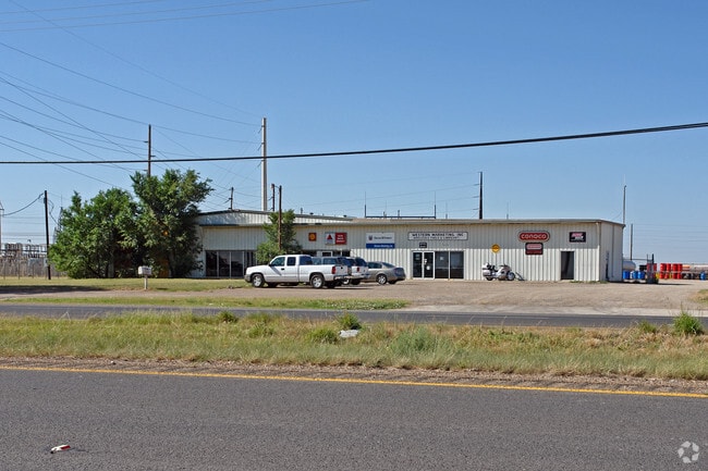

Property Detail
3302 E Slaton Rd
Lubbock, TX
STEELE JOHN B L 4-A & BLK S SEC 4 AB 448 TR E1-B
R73718
Lubbock
Warehouse
Texas
B and X Area of moderate flood hazard, usually the area between the limits of the 100-year and 500-year floods.
45
2024
5.10 AC
2025
South Outer Lubbock
002500
Lubbock
20,125 SF
NEARBY LISTINGS FOR SALE OR LEASE
DEMOGRAPHICS near 3302 E Slaton Rd
1 mile
3 mile
5 mile
2025 Total Population
366
3,900
51,921
2030 Population
385
4,129
54,409
Pop Growth 2025-2030
+ 5.19%
+ 5.87%
+ 4.79%
Average Age
43
39
36
2025 Total Households
67
1,140
19,315
HH Growth 2025-2030
+ 7.46%
+ 6.58%
+ 5.01%
Median Household Inc
$22,300
$53,450
$51,594
Avg Household Size
2.60
2.70
2.60
2025 Avg HH Vehicles
2.00
2.00
2.00
Median Home Value
$59,374
$115,407
$142,566
Median Year Built
1995
1987
1979
Nearby Places
Map Layers
Map Styles
 Street
 Aerial
Transit
 Traffic
 Biking
Places
Listings with unknown addresses are not visible on the map
- Restaurants
- Banks
- Shops
- Fitness
- Groceries
PUBLIC TRANSPORTATION
AIRPORT
Lubbock Preston Smith International
Drive
Walk
Distance
Lubbock Preston Smith International
29 min
17.4 mi
Nearby Properties
Address
Land Use
TOTAL SIZE
Lot Size
Zoning
Address
Land Use
TOTAL SIZE
Lot Size
Zoning
709,350 SF
98.60 AC
Address
Land Use
TOTAL SIZE
Lot Size
Zoning
76,680 SF
4.95 AC
Address
Land Use
TOTAL SIZE
Lot Size
Zoning
421,200 SF
43.22 AC
Address
Land Use
TOTAL SIZE
Lot Size
Zoning
205,150 SF
23.43 AC
Address
Land Use
TOTAL SIZE
Lot Size
Zoning
150,000 SF
216.67 AC
Address
Land Use
TOTAL SIZE
Lot Size
Zoning
192,128 SF
9.87 AC
Address
Land Use
TOTAL SIZE
Lot Size
Zoning
189,737 SF
31 AC
Address
Land Use
TOTAL SIZE
Lot Size
Zoning
88,310 SF
9.95 AC
Address
Land Use
TOTAL SIZE
Lot Size
Zoning
367,283 SF
36.77 AC
Address
Land Use
TOTAL SIZE
Lot Size
Zoning
5,000 SF
190 AC
Address
Land Use
TOTAL SIZE
Lot Size
Zoning
233,241 SF
12.52 AC
Address
Land Use
TOTAL SIZE
Lot Size
Zoning
112,725 SF
20 AC
Address
Land Use
TOTAL SIZE
Lot Size
Zoning
46,034 SF
14.04 AC
Address
Land Use
TOTAL SIZE
Lot Size
Zoning
14,008 SF
92.33 AC
Address
Land Use
TOTAL SIZE
Lot Size
Zoning
54,190 SF
10.09 AC
Address
Land Use
TOTAL SIZE
Lot Size
Zoning
176.26 AC
Address
Land Use
TOTAL SIZE
Lot Size
Zoning
53,253 SF
24.99 AC
Address
Land Use
TOTAL SIZE
Lot Size
Zoning
144,204 SF
12.37 AC
Address
Land Use
TOTAL SIZE
Lot Size
Zoning
105.58 AC
Address
Land Use
TOTAL SIZE
Lot Size
Zoning
19,365 SF
5.70 AC
Address
Land Use
TOTAL SIZE
Lot Size
Zoning
62,175 SF
7.09 AC
Address
Land Use
TOTAL SIZE
Lot Size
Zoning
160,130 SF
6.64 AC
Address
Land Use
TOTAL SIZE
Lot Size
Zoning
21,079 SF
15.14 AC
Address
Land Use
TOTAL SIZE
Lot Size
Zoning
102,822 SF
6.40 AC
Address
Land Use
TOTAL SIZE
Lot Size
Zoning
12,965 SF
12.97 AC
Address
Land Use
TOTAL SIZE
Lot Size
Zoning
51,050 SF
4.34 AC
Address
Land Use
TOTAL SIZE
Lot Size
Zoning
23,330 SF
6.84 AC
Address
Land Use
TOTAL SIZE
Lot Size
Zoning
6,888 SF
5.06 AC
Address
Land Use
TOTAL SIZE
Lot Size
Zoning
69,463 SF
18.51 AC
Address
Land Use
TOTAL SIZE
Lot Size
Zoning
21,130 SF
8.94 AC
The World's #1 Commercial Real Estate Marketplace
Connect with us
© 2026 CoStar Group
The information above has been obtained from sources believed reliable. While we do not doubt its accuracy we have not verified it and make no guarantee, warranty or representation about it. It is your responsibility to independently confirm its accuracy and completeness. Any projections, opinions, assumptions, or estimates used are for example only and do not represent the current or future performance of the property. The value of this transaction to you depends on tax and other factors which should be evaluated by your tax, financial, and legal advisors. You and your advisors should conduct a careful, independent investigation of the property to determine to your satisfaction the suitability of the property for your needs.