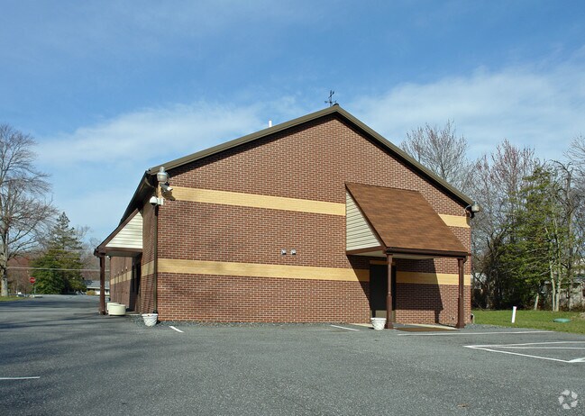
Property Record
3303 Emmorton Rd, Abingdon, MD 21009

NEARBY LISTINGS FOR SALE OR LEASE
Property Detail
3303 Emmorton Rd
01-019910
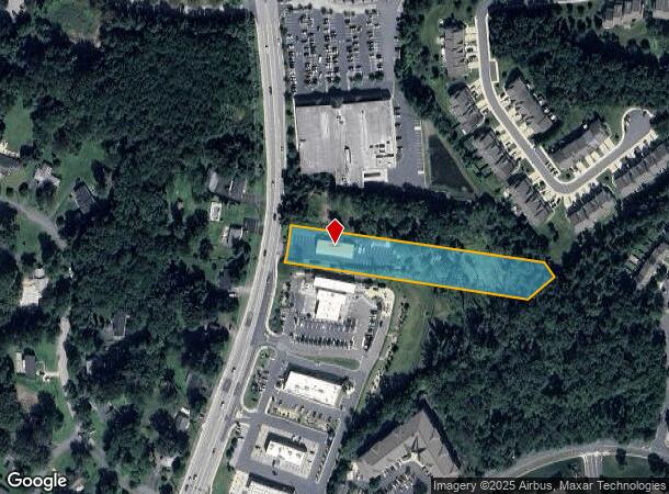
1.86 ACRE 3303 EMMORTON ROAD S OF NORRIS CORNER
Religious
Harford
X
Maryland
24025C0256E
1.86 AC
0
Outlying Harford County
2025
Baltimore
301107
Baltimore-Columbia-Towson, MD
3,600 SF
DEMOGRAPHICS near 3303 Emmorton Rd
1 Mile
3 Mile
5 Mile
2024 Total Population
14,326
52,609
126,419
2029 Population
14,701
53,978
129,922
Pop Growth 2024-2029
+ 2.62%
+ 2.60%
+ 2.77%
Average Age
38
39
40
2024 Total Households
5,909
19,810
47,611
HH Growth 2024-2029
+ 2.57%
+ 2.61%
+ 2.82%
Median Household Inc
$86,537
$96,169
$93,457
Avg Household Size
2.40
2.60
2.60
2024 Avg HH Vehicles
2.00
2.00
2.00
Median Home Value
$257,172
$301,397
$306,888
Median Year Built
1988
1991
1988
Nearby Places
Map Layers
Map Styles
 Street
 Aerial
- Restaurants
- Banks
- Shops
- Fitness
- Groceries
PUBLIC TRANSPORTATION
COMMUTER RAIL
Edgewood (Penn Line - Maryland Area Regional Commuter Trains (The MARC))
DRIVE
WALK
Distance
Edgewood (Penn Line - Maryland Area Regional Commuter Trains (The MARC))
10 min
4.8 mi
AIRPORT
Baltimore/Washington International Thurgood Marshall
DRIVE
WALK
Distance
Baltimore/Washington International Thurgood Marshall
47 min
33.0 mi
Freight Ports
Port of Baltimore
DRIVE
WALK
Distance
Port of Baltimore
36 min
26.5 mi
Nearby Properties
Address
Land Use
TOTAL SIZE
Lot Size
Zoning
Address
Land Use
TOTAL SIZE
Lot Size
Zoning
5,501.68 AC
R1
Address
Land Use
TOTAL SIZE
Lot Size
Zoning
13,400 SF
37.89 AC
B3
Address
Land Use
TOTAL SIZE
Lot Size
Zoning
407,868 SF
10.39 AC
MO
Address
Land Use
TOTAL SIZE
Lot Size
Zoning
77.35 AC
R2
Address
Land Use
TOTAL SIZE
Lot Size
Zoning
15,250 SF
17.86 AC
CI
Address
Land Use
TOTAL SIZE
Lot Size
Zoning
266,913 SF
28.35 AC
R4
Address
Land Use
TOTAL SIZE
Lot Size
Zoning
291,027 SF
276 AC
R4
Address
Land Use
TOTAL SIZE
Lot Size
Zoning
822,410 SF
44.24 AC
GI
Address
Land Use
TOTAL SIZE
Lot Size
Zoning
59,724 SF
20.79 AC
C1
Address
Land Use
TOTAL SIZE
Lot Size
Zoning
35,698 SF
16.27 AC
B2
Address
Land Use
TOTAL SIZE
Lot Size
Zoning
246,560 SF
14.57 AC
LI
Address
Land Use
TOTAL SIZE
Lot Size
Zoning
61,350 SF
20 AC
B2
Address
Land Use
TOTAL SIZE
Lot Size
Zoning
43,311 SF
6.76 AC
R3 R4
Address
Land Use
TOTAL SIZE
Lot Size
Zoning
124,268 SF
10.85 AC
R3
Address
Land Use
TOTAL SIZE
Lot Size
Zoning
1,690 SF
76.45 AC
R4
Address
Land Use
TOTAL SIZE
Lot Size
Zoning
116,822 SF
13.42 AC
CI
Address
Land Use
TOTAL SIZE
Lot Size
Zoning
31,521 SF
9.72 AC
R3 R4
Address
Land Use
TOTAL SIZE
Lot Size
Zoning
70,794 SF
9.75 AC
R2
Address
Land Use
TOTAL SIZE
Lot Size
Zoning
109,398 SF
11.36 AC
CI
Address
Land Use
TOTAL SIZE
Lot Size
Zoning
97,985 SF
12.12 AC
CI
Address
Land Use
TOTAL SIZE
Lot Size
Zoning
134,875 SF
40.88 AC
CI
Address
Land Use
TOTAL SIZE
Lot Size
Zoning
113,173 SF
17.04 AC
CI
Address
Land Use
TOTAL SIZE
Lot Size
Zoning
94,312 SF
14.40 AC
LI
Address
Land Use
TOTAL SIZE
Lot Size
Zoning
255,464 SF
19.15 AC
GI
Address
Land Use
TOTAL SIZE
Lot Size
Zoning
35,400 SF
28.02 AC
R1
Address
Land Use
TOTAL SIZE
Lot Size
Zoning
49,131 SF
14.39 AC
CI
Address
Land Use
TOTAL SIZE
Lot Size
Zoning
35,058 SF
3.69 AC
CI
Address
Land Use
TOTAL SIZE
Lot Size
Zoning
116,650 SF
47.59 AC
B3
Address
Land Use
TOTAL SIZE
Lot Size
Zoning
97,454 SF
14.72 AC
L1
Address
Land Use
TOTAL SIZE
Lot Size
Zoning
67,184 SF
8.51 AC
GI
The World's #1 Commercial Real Estate Marketplace
Connect with us
© 2026 CoStar Group
The information above has been obtained from sources believed reliable. While we do not doubt its accuracy we have not verified it and make no guarantee, warranty or representation about it. It is your responsibility to independently confirm its accuracy and completeness. Any projections, opinions, assumptions, or estimates used are for example only and do not represent the current or future performance of the property. The value of this transaction to you depends on tax and other factors which should be evaluated by your tax, financial, and legal advisors. You and your advisors should conduct a careful, independent investigation of the property to determine to your satisfaction the suitability of the property for your needs.