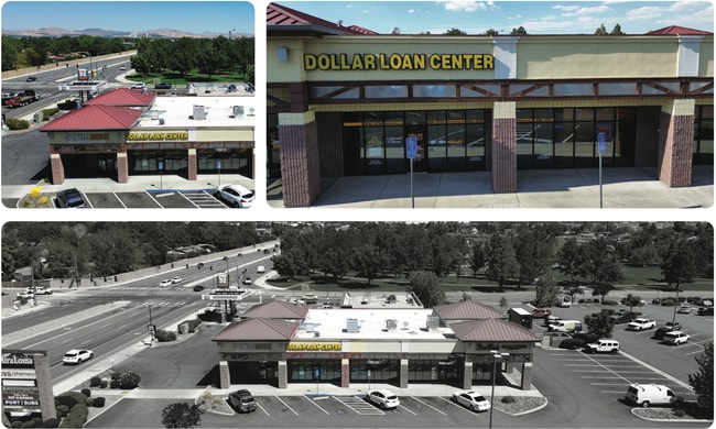
Property Record
3304 S Mccarran Blvd, Reno, NV 89502

NEARBY LISTINGS FOR SALE OR LEASE
Property Detail
3304 S Mccarran Blvd
Reno, NV
_Unspecified
021-281-13
RS 4409 LT C
Commercialnec
Washoe
X
Nevada
32031C3251G
c
2025
0.65 AC
2026
Airport
002105
Reno/Sparks
5,883 SF
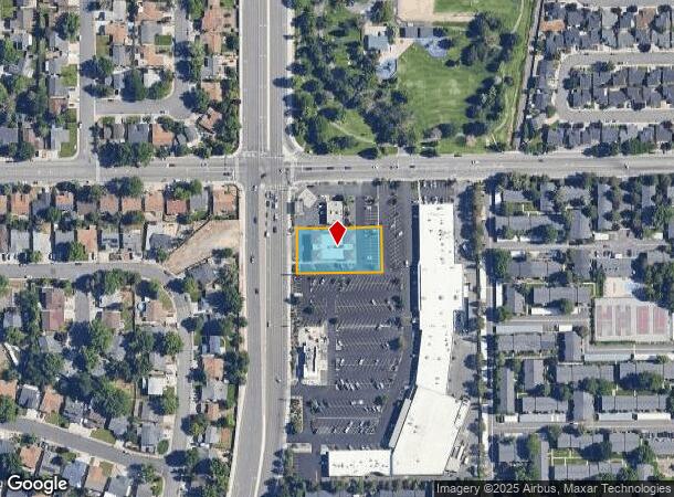
DEMOGRAPHICS near 3304 S Mccarran Blvd
1 Mile
3 Mile
5 Mile
2024 Total Population
10,170
50,561
188,599
2029 Population
10,646
53,267
198,695
Pop Growth 2024-2029
+ 4.68%
+ 5.35%
+ 5.35%
Average Age
41
38
40
2024 Total Households
4,249
20,292
79,982
HH Growth 2024-2029
+ 4.99%
+ 5.57%
+ 5.52%
Median Household Inc
$72,214
$64,095
$64,276
Avg Household Size
2.30
2.40
2.30
2024 Avg HH Vehicles
2.00
2.00
2.00
Median Home Value
$372,419
$402,998
$449,920
Median Year Built
1978
1981
1981
Nearby Places
Map Layers
Map Styles
 Street
 Aerial
- Restaurants
- Banks
- Shops
- Fitness
- Groceries
PUBLIC TRANSPORTATION
COMMUTER RAIL
DRIVE
WALK
Distance
12 min
5.8 mi
AIRPORT
Reno/Tahoe International
DRIVE
WALK
Distance
Reno/Tahoe International
27 min
7.5 mi
SALE & LEASE HISTORY
LISTING DATE
SALE/LEASE

Feb 22, 2023
For Lease
Aug 15, 2024
For Lease
Nearby Properties
Address
Land Use
TOTAL SIZE
Lot Size
Zoning
Address
Land Use
TOTAL SIZE
Lot Size
Zoning
1,638,272 SF
17.11 AC
MU
Address
Land Use
TOTAL SIZE
Lot Size
Zoning
762,384 SF
1,131.28 AC
MA
Address
Land Use
TOTAL SIZE
Lot Size
Zoning
799,762 SF
13.30 AC
MU
Address
Land Use
TOTAL SIZE
Lot Size
Zoning
390,743 SF
22.20 AC
IC
Address
Land Use
TOTAL SIZE
Lot Size
Zoning
1,051,043 SF
78.81 AC
PD
Address
Land Use
TOTAL SIZE
Lot Size
Zoning
425,118 SF
30.37 AC
IC
Address
Land Use
TOTAL SIZE
Lot Size
Zoning
759,161 SF
37.37 AC
MU
Address
Land Use
TOTAL SIZE
Lot Size
Zoning
991,800 SF
51.03 AC
PD
Address
Land Use
TOTAL SIZE
Lot Size
Zoning
893,055 SF
52.71 AC
MA
Address
Land Use
TOTAL SIZE
Lot Size
Zoning
451,635 SF
15 AC
PD
Address
Land Use
TOTAL SIZE
Lot Size
Zoning
421,744 SF
12.07 AC
MS
Address
Land Use
TOTAL SIZE
Lot Size
Zoning
500,079 SF
45.66 AC
SPD
Address
Land Use
TOTAL SIZE
Lot Size
Zoning
335,490 SF
19.54 AC
PD
Address
Land Use
TOTAL SIZE
Lot Size
Zoning
342,019 SF
23.32 AC
MF14
Address
Land Use
TOTAL SIZE
Lot Size
Zoning
366,641 SF
37.91 AC
MA
Address
Land Use
TOTAL SIZE
Lot Size
Zoning
231,329 SF
8.37 AC
GC
Address
Land Use
TOTAL SIZE
Lot Size
Zoning
591,000 SF
5.46 AC
MU
Address
Land Use
TOTAL SIZE
Lot Size
Zoning
187,900 SF
14.83 AC
PD
Address
Land Use
TOTAL SIZE
Lot Size
Zoning
322,180 SF
2.87 AC
MU
Address
Land Use
TOTAL SIZE
Lot Size
Zoning
149,324 SF
4.34 AC
PD
Address
Land Use
TOTAL SIZE
Lot Size
Zoning
270,950 SF
14.86 AC
IC
Address
Land Use
TOTAL SIZE
Lot Size
Zoning
170,507 SF
17.24 AC
GC
Address
Land Use
TOTAL SIZE
Lot Size
Zoning
378.16 AC
GR
Address
Land Use
TOTAL SIZE
Lot Size
Zoning
1,269,958 SF
54.19 AC
I
Address
Land Use
TOTAL SIZE
Lot Size
Zoning
80,970 SF
5.28 AC
MS
Address
Land Use
TOTAL SIZE
Lot Size
Zoning
181,296 SF
2.65 AC
MU
Address
Land Use
TOTAL SIZE
Lot Size
Zoning
146,586 SF
2.94 AC
IC
Address
Land Use
TOTAL SIZE
Lot Size
Zoning
381,852 SF
18.60 AC
GC
Address
Land Use
TOTAL SIZE
Lot Size
Zoning
394,767 SF
23.50 AC
PD
Address
Land Use
TOTAL SIZE
Lot Size
Zoning
84,778 SF
42.67 AC
MA
The World's #1 Commercial Real Estate Marketplace
Connect with us
© 2025 CoStar Group
The information above has been obtained from sources believed reliable. While we do not doubt its accuracy we have not verified it and make no guarantee, warranty or representation about it. It is your responsibility to independently confirm its accuracy and completeness. Any projections, opinions, assumptions, or estimates used are for example only and do not represent the current or future performance of the property. The value of this transaction to you depends on tax and other factors which should be evaluated by your tax, financial, and legal advisors. You and your advisors should conduct a careful, independent investigation of the property to determine to your satisfaction the suitability of the property for your needs.