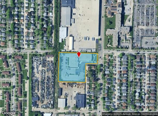
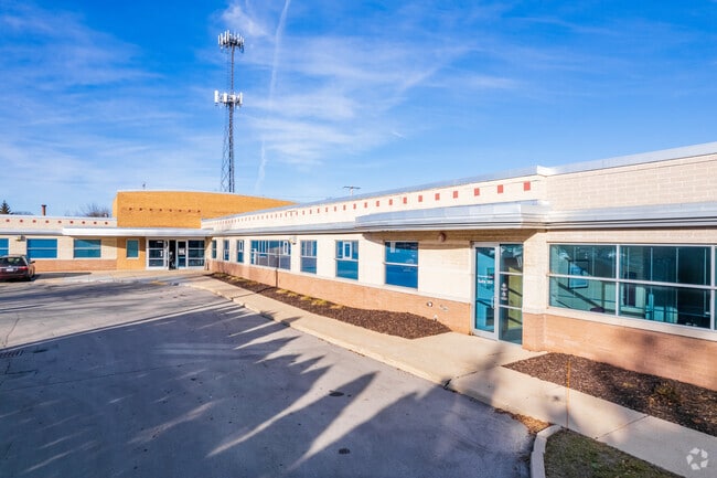
Property Record
3305 S 20Th St, Milwaukee, WI 53215

Current Lease Availabilities
NEARBY LISTINGS FOR SALE OR LEASE
Property Detail
3305 S 20Th St
Milwaukee-Waukesha-West Allis, WI
Certified Surv Map 6773
534-0921-000-3
CERT SURVEY MAP NO 6773 IN SE 1/4 OF NW 1/4 SEC 18-6-22 PARCEL 1
Medicalbuilding
Milwaukee
X
Wisconsin
55079C0152E
1
2024
2.59 AC
2024
Milwaukee Near SW
020100
Milwaukee/Madison
26,687 SF
DEMOGRAPHICS near 3305 S 20Th St
1 Mile
3 Mile
5 Mile
2024 Total Population
23,074
183,786
377,864
2029 Population
22,414
178,894
369,345
Pop Growth 2024-2029
(2.86%)
(2.66%)
(2.25%)
Average Age
35
36
38
2024 Total Households
8,134
70,686
160,250
HH Growth 2024-2029
(2.98%)
(2.75%)
(2.20%)
Median Household Inc
$52,115
$52,560
$55,200
Avg Household Size
2.70
2.50
2.20
2024 Avg HH Vehicles
2.00
2.00
1.00
Median Home Value
$154,045
$168,401
$184,911
Median Year Built
1948
1948
1953
Nearby Places
- Restaurants
- Banks
- Shops
- Fitness
- Groceries
PUBLIC TRANSPORTATION
COMMUTER RAIL
General Mitchell Intl. Airport Amtrak Station (Hiawatha Service - Amtrak)
DRIVE
WALK
Distance
General Mitchell Intl. Airport Amtrak Station (Hiawatha Service - Amtrak)
11 min
4.2 mi
Milwaukee (Empire Builder - Amtrak)
DRIVE
WALK
Distance
Milwaukee (Empire Builder - Amtrak)
11 min
5.9 mi
AIRPORT
General Mitchell International
DRIVE
WALK
Distance
General Mitchell International
11 min
4.4 mi
Freight Ports
Port Milwaukee
DRIVE
WALK
Distance
Port Milwaukee
7 min
2.7 mi
Nearby Properties
Address
Land Use
TOTAL SIZE
Lot Size
Zoning
Address
Land Use
TOTAL SIZE
Lot Size
Zoning
41.05 AC
IO2
Address
Land Use
TOTAL SIZE
Lot Size
Zoning
319,559 SF
6.29 AC
PD
Address
Land Use
TOTAL SIZE
Lot Size
Zoning
204,809 SF
1.04 AC
IM
Address
Land Use
TOTAL SIZE
Lot Size
Zoning
12.02 AC
IO2
Address
Land Use
TOTAL SIZE
Lot Size
Zoning
48.34 AC
IO1
Address
Land Use
TOTAL SIZE
Lot Size
Zoning
110,000 SF
7.59 AC
TL
Address
Land Use
TOTAL SIZE
Lot Size
Zoning
2,610 SF
1.04 AC
IM
Address
Land Use
TOTAL SIZE
Lot Size
Zoning
11.38 AC
TL
Address
Land Use
TOTAL SIZE
Lot Size
Zoning
120,000 SF
1.10 AC
IM
Address
Land Use
TOTAL SIZE
Lot Size
Zoning
222,100 SF
1.29 AC
PD
Address
Land Use
TOTAL SIZE
Lot Size
Zoning
197,354 SF
18 AC
CS
Address
Land Use
TOTAL SIZE
Lot Size
Zoning
0.43 AC
RT3
Address
Land Use
TOTAL SIZE
Lot Size
Zoning
183,291 SF
11.48 AC
IM
Address
Land Use
TOTAL SIZE
Lot Size
Zoning
23.09 AC
Address
Land Use
TOTAL SIZE
Lot Size
Zoning
188,328 SF
22.41 AC
PD
Address
Land Use
TOTAL SIZE
Lot Size
Zoning
17.47 AC
R2
Address
Land Use
TOTAL SIZE
Lot Size
Zoning
39.81 AC
Address
Land Use
TOTAL SIZE
Lot Size
Zoning
122,602 SF
0.89 AC
IM
Address
Land Use
TOTAL SIZE
Lot Size
Zoning
238,201 SF
17.96 AC
PUDR5
Address
Land Use
TOTAL SIZE
Lot Size
Zoning
20.61 AC
TL
Address
Land Use
TOTAL SIZE
Lot Size
Zoning
162,138 SF
9.15 AC
PD
Address
Land Use
TOTAL SIZE
Lot Size
Zoning
213,964 SF
13.94 AC
PUDR5
Address
Land Use
TOTAL SIZE
Lot Size
Zoning
132,289 SF
5.34 AC
PD
Address
Land Use
TOTAL SIZE
Lot Size
Zoning
83,827 SF
2.07 AC
PD
Address
Land Use
TOTAL SIZE
Lot Size
Zoning
76.97 AC
IH
Address
Land Use
TOTAL SIZE
Lot Size
Zoning
360,000 SF
14.60 AC
IL1
Address
Land Use
TOTAL SIZE
Lot Size
Zoning
12.47 AC
Address
Land Use
TOTAL SIZE
Lot Size
Zoning
20.49 AC
TL
Address
Land Use
TOTAL SIZE
Lot Size
Zoning
4.27 AC
Address
Land Use
TOTAL SIZE
Lot Size
Zoning
152,130 SF
7.68 AC
PD
The World's #1 Commercial Real Estate Marketplace
Connect with us
© 2025 CoStar Group
The information above has been obtained from sources believed reliable. While we do not doubt its accuracy we have not verified it and make no guarantee, warranty or representation about it. It is your responsibility to independently confirm its accuracy and completeness. Any projections, opinions, assumptions, or estimates used are for example only and do not represent the current or future performance of the property. The value of this transaction to you depends on tax and other factors which should be evaluated by your tax, financial, and legal advisors. You and your advisors should conduct a careful, independent investigation of the property to determine to your satisfaction the suitability of the property for your needs.