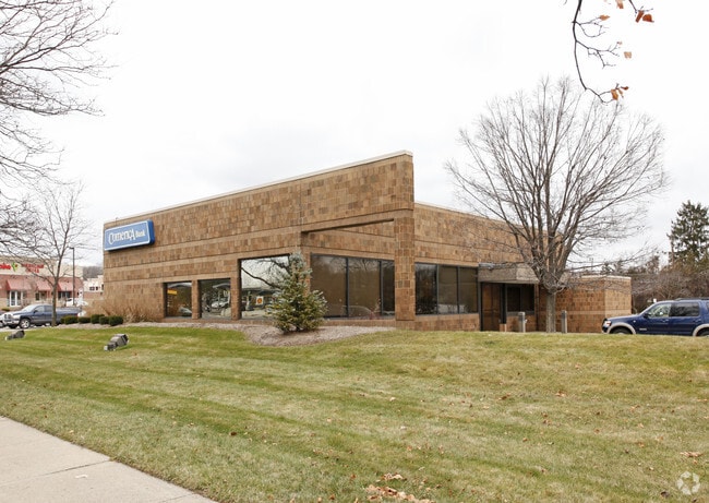
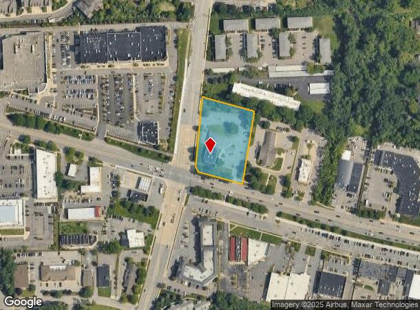
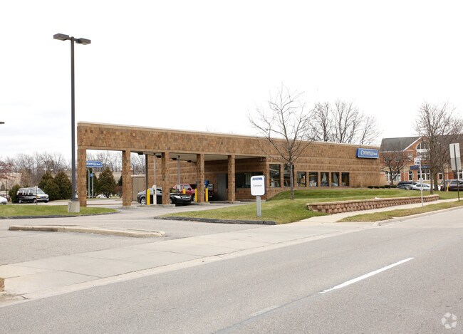
Property Record
3305 Washtenaw Ave, Ann Arbor, MI 48104
NEARBY LISTINGS FOR SALE OR LEASE
Property Detail
3305 Washtenaw Ave
12-02-200-008
COM NW COR TH S 89 DEG 55 MIN E 1336.32 FT TH S 0 DEG 55 MIN W 597.08 FT FOR POB TH S 8 DEG 34 MIN W 75.74 FT TH S 71 DEG 55
Commercialnec
Washtenaw
X
Michigan
26161C0264E
1.45 AC
2025
Washtenaw W of 23
2025
Detroit
405300
Ann Arbor, MI
4,416 SF
DEMOGRAPHICS near 3305 Washtenaw Ave
1 Mile
3 Mile
5 Mile
2024 Total Population
6,648
89,468
189,800
2029 Population
6,569
88,154
187,921
Pop Growth 2024-2029
(1.19%)
(1.47%)
(0.99%)
Average Age
42
34
36
2024 Total Households
3,068
35,975
79,580
HH Growth 2024-2029
(1.34%)
(1.41%)
(1.01%)
Median Household Inc
$85,803
$59,302
$70,123
Avg Household Size
2.10
2.10
2.10
2024 Avg HH Vehicles
2.00
1.00
2.00
Median Home Value
$296,505
$351,123
$371,703
Median Year Built
1962
1974
1975
Nearby Places
Map Layers
Map Styles
 Street
 Aerial
- Restaurants
- Banks
- Shops
- Fitness
- Groceries
PUBLIC TRANSPORTATION
COMMUTER RAIL
Ann Arbor Amtrak Station (Wolverine - Amtrak)
DRIVE
WALK
Distance
Ann Arbor Amtrak Station (Wolverine - Amtrak)
8 min
3.7 mi
AIRPORT
Detroit Metro Wayne County
DRIVE
WALK
Distance
Detroit Metro Wayne County
30 min
22.9 mi
Freight Ports
Port of Toledo
DRIVE
WALK
Distance
Port of Toledo
72 min
55.9 mi
Nearby Properties
Address
Land Use
TOTAL SIZE
Lot Size
Zoning
Address
Land Use
TOTAL SIZE
Lot Size
Zoning
235,070 SF
0.80 AC
D1
Address
Land Use
TOTAL SIZE
Lot Size
Zoning
358,683 SF
5.42 AC
PUD
Address
Land Use
TOTAL SIZE
Lot Size
Zoning
407,374 SF
35.17 AC
C3
Address
Land Use
TOTAL SIZE
Lot Size
Zoning
268,612 SF
0.74 AC
D1
Address
Land Use
TOTAL SIZE
Lot Size
Zoning
186,029 SF
2.06 AC
D2
Address
Land Use
TOTAL SIZE
Lot Size
Zoning
Address
Land Use
TOTAL SIZE
Lot Size
Zoning
211,670 SF
0.54 AC
D1
Address
Land Use
TOTAL SIZE
Lot Size
Zoning
222,126 SF
0.52 AC
D1
Address
Land Use
TOTAL SIZE
Lot Size
Zoning
2,668 SF
31.60 AC
PUD
Address
Land Use
TOTAL SIZE
Lot Size
Zoning
189,221 SF
0.58 AC
D1
Address
Land Use
TOTAL SIZE
Lot Size
Zoning
315,108 SF
6.57 AC
C1B
Address
Land Use
TOTAL SIZE
Lot Size
Zoning
524,946 SF
10.43 AC
PUD
Address
Land Use
TOTAL SIZE
Lot Size
Zoning
173,885 SF
0.45 AC
D1
Address
Land Use
TOTAL SIZE
Lot Size
Zoning
36,000 SF
27.61 AC
BI
Address
Land Use
TOTAL SIZE
Lot Size
Zoning
140,840 SF
0.50 AC
D1
Address
Land Use
TOTAL SIZE
Lot Size
Zoning
357,978 SF
19.32 AC
R4B
Address
Land Use
TOTAL SIZE
Lot Size
Zoning
140,670 SF
1.63 AC
C2B
Address
Land Use
TOTAL SIZE
Lot Size
Zoning
133,830 SF
0.59 AC
D1
Address
Land Use
TOTAL SIZE
Lot Size
Zoning
112,994 SF
45.12 AC
IH
Address
Land Use
TOTAL SIZE
Lot Size
Zoning
177,763 SF
0.91 AC
D2
Address
Land Use
TOTAL SIZE
Lot Size
Zoning
99,982 SF
0.35 AC
D1
Address
Land Use
TOTAL SIZE
Lot Size
Zoning
127,076 SF
0.39 AC
D1
Address
Land Use
TOTAL SIZE
Lot Size
Zoning
333,275 SF
0.65 AC
D1
Address
Land Use
TOTAL SIZE
Lot Size
Zoning
214,559 SF
16.18 AC
PUD
Address
Land Use
TOTAL SIZE
Lot Size
Zoning
37,500 SF
25.94 AC
BI
Address
Land Use
TOTAL SIZE
Lot Size
Zoning
273,440 SF
73.06 AC
RRA
Address
Land Use
TOTAL SIZE
Lot Size
Zoning
208,890 SF
A-1
Address
Land Use
TOTAL SIZE
Lot Size
Zoning
125,073 SF
0.26 AC
D1
Address
Land Use
TOTAL SIZE
Lot Size
Zoning
1.19 AC
R4C
Address
Land Use
TOTAL SIZE
Lot Size
Zoning
17,672 SF
33.37 AC
BI
The World's #1 Commercial Real Estate Marketplace
Connect with us
© 2025 CoStar Group
The information above has been obtained from sources believed reliable. While we do not doubt its accuracy we have not verified it and make no guarantee, warranty or representation about it. It is your responsibility to independently confirm its accuracy and completeness. Any projections, opinions, assumptions, or estimates used are for example only and do not represent the current or future performance of the property. The value of this transaction to you depends on tax and other factors which should be evaluated by your tax, financial, and legal advisors. You and your advisors should conduct a careful, independent investigation of the property to determine to your satisfaction the suitability of the property for your needs.