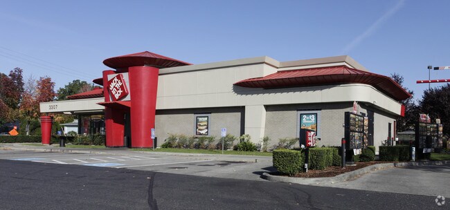
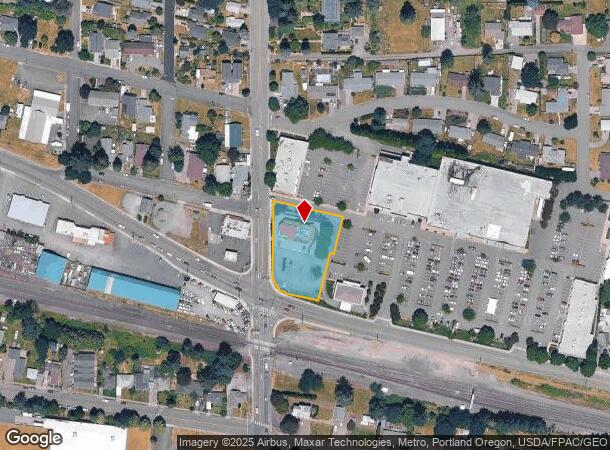
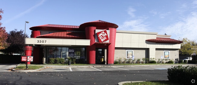
Property Record
3307 Evergreen Way, Washougal, WA 98671

NEARBY LISTINGS FOR SALE OR LEASE
Property Detail
3307 Evergreen Way
Portland-Vancouver-Hillsboro, OR-WA
Kisers Addition
076520-000
KISERS ADDN WASHOUGAL LOT 1 #1 LOT 2 #2 LOTS 19 & 20 .89 FOR ASSESSOR USE ONLY TT IN SEQ SEC 8-1-4E DAF: BEG AT NW COR OF LOT 20 KISERS ADDN VOL C PG 90 TH S 00DG 35MIN 06SEC E ALG W LI OF SD LOT 20 A DIST OF 185.91 FT TO TPOB TH CONTG S 00DG 35MIN 0
Restaurantdrivein
Clark
X
Washington
53011C0554E
1-2,1
2025
0.89 AC
2025
Camas/Washougal
040513
Portland
2,848 SF
DEMOGRAPHICS near 3307 Evergreen Way
1 Mile
3 Mile
5 Mile
2024 Total Population
7,827
22,005
56,207
2029 Population
8,400
23,689
58,850
Pop Growth 2024-2029
+ 7.32%
+ 7.65%
+ 4.70%
Average Age
41
41
40
2024 Total Households
2,890
8,172
20,098
HH Growth 2024-2029
+ 7.44%
+ 7.76%
+ 4.67%
Median Household Inc
$90,190
$93,904
$94,821
Avg Household Size
2.70
2.70
2.80
2024 Avg HH Vehicles
2.00
2.00
2.00
Median Home Value
$413,219
$486,728
$479,198
Median Year Built
1991
1996
1992
Nearby Places
Map Layers
Map Styles
 Street
 Aerial
- Restaurants
- Banks
- Shops
- Fitness
- Groceries
PUBLIC TRANSPORTATION
AIRPORT
Portland International
DRIVE
WALK
Distance
Portland International
27 min
16.7 mi
Nearby Properties
Address
Land Use
TOTAL SIZE
Lot Size
Zoning
Address
Land Use
TOTAL SIZE
Lot Size
Zoning
262,320 SF
25.24 AC
IP
Address
Land Use
TOTAL SIZE
Lot Size
Zoning
123,157 SF
24.23 AC
GR 5
Address
Land Use
TOTAL SIZE
Lot Size
Zoning
114,696 SF
2.29 AC
MF-18
Address
Land Use
TOTAL SIZE
Lot Size
Zoning
142,571 SF
1.73 AC
TC-C
Address
Land Use
TOTAL SIZE
Lot Size
Zoning
65,604 SF
11.35 AC
R-7.5
Address
Land Use
TOTAL SIZE
Lot Size
Zoning
83,139 SF
7.36 AC
HI
Address
Land Use
TOTAL SIZE
Lot Size
Zoning
256,888 SF
18.91 AC
TC-C
Address
Land Use
TOTAL SIZE
Lot Size
Zoning
108,108 SF
5.35 AC
IP
Address
Land Use
TOTAL SIZE
Lot Size
Zoning
64,400 SF
3.30 AC
MF-18
Address
Land Use
TOTAL SIZE
Lot Size
Zoning
75,360 SF
4.46 AC
RC
Address
Land Use
TOTAL SIZE
Lot Size
Zoning
51,600 SF
2.35 AC
AR-16
Address
Land Use
TOTAL SIZE
Lot Size
Zoning
56,376 SF
4.04 AC
CC
Address
Land Use
TOTAL SIZE
Lot Size
Zoning
69,043 SF
0.92 AC
TC-C
Address
Land Use
TOTAL SIZE
Lot Size
Zoning
661.52 AC
GSO
Address
Land Use
TOTAL SIZE
Lot Size
Zoning
49,500 SF
6.48 AC
HI
Address
Land Use
TOTAL SIZE
Lot Size
Zoning
53,663 SF
3.40 AC
CH
Address
Land Use
TOTAL SIZE
Lot Size
Zoning
97,260 SF
4.70 AC
CH
Address
Land Use
TOTAL SIZE
Lot Size
Zoning
49,522 SF
5.05 AC
HI
Address
Land Use
TOTAL SIZE
Lot Size
Zoning
49,500 SF
5.84 AC
HI
Address
Land Use
TOTAL SIZE
Lot Size
Zoning
38.94 AC
OS
Address
Land Use
TOTAL SIZE
Lot Size
Zoning
16,384 SF
61.53 AC
IP
Address
Land Use
TOTAL SIZE
Lot Size
Zoning
61,500 SF
1.64 AC
MF-18
Address
Land Use
TOTAL SIZE
Lot Size
Zoning
47,668 SF
73.93 AC
P/OS
Address
Land Use
TOTAL SIZE
Lot Size
Zoning
48,352 SF
0.58 AC
CH
Address
Land Use
TOTAL SIZE
Lot Size
Zoning
104,652 SF
1.90 AC
IP
Address
Land Use
TOTAL SIZE
Lot Size
Zoning
42,870 SF
3.43 AC
MF-18
Address
Land Use
TOTAL SIZE
Lot Size
Zoning
54,074 SF
0.20 AC
TC-C
Address
Land Use
TOTAL SIZE
Lot Size
Zoning
48,783 SF
2.53 AC
R1-15
Address
Land Use
TOTAL SIZE
Lot Size
Zoning
61,136 SF
9.73 AC
HI
The World's #1 Commercial Real Estate Marketplace
Connect with us
© 2025 CoStar Group
The information above has been obtained from sources believed reliable. While we do not doubt its accuracy we have not verified it and make no guarantee, warranty or representation about it. It is your responsibility to independently confirm its accuracy and completeness. Any projections, opinions, assumptions, or estimates used are for example only and do not represent the current or future performance of the property. The value of this transaction to you depends on tax and other factors which should be evaluated by your tax, financial, and legal advisors. You and your advisors should conduct a careful, independent investigation of the property to determine to your satisfaction the suitability of the property for your needs.