Property Record
3321 Ohio Rd, Ottawa, KS 66067

Property Detail
3321 Ohio Rd
098-27-0-00-00-006.00-0
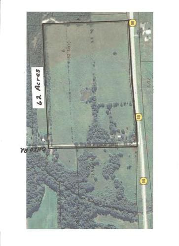
S27, T16, R20E, ACRES 62.2, TR BEG SW/C SW4 E1980 N1386 W1980 S1386 TO POB LESS ROW
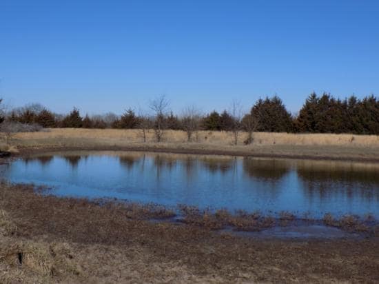
Ranch
FRANKLIN
A1
Kansas
B and X Area of moderate flood hazard, usually the area between the limits of the 100-year and 500-year floods.
62.06 AC
2024
Ottawa
2025
Kansas City
954500
Ottawa, KS
NEARBY LISTINGS FOR SALE OR LEASE
-
-
View all Ottawa listings for sale on LoopNet.com
DEMOGRAPHICS near 3321 Ohio Rd
1 mile
3 mile
5 mile
2025 Total Population
38
609
11,880
2030 Population
37
607
12,085
Pop Growth 2025-2030
(2.63%)
(0.33%)
+ 1.73%
Average Age
45
44
39
2025 Total Households
15
239
4,707
HH Growth 2025-2030
(6.67%)
(0.42%)
+ 1.78%
Median Household Inc
$93,749
$80,903
$65,639
Avg Household Size
2.40
2.50
2.40
2025 Avg HH Vehicles
4.00
3.00
2.00
Median Home Value
$333,333
$301,220
$165,471
Median Year Built
1996
1990
1965
Nearby Places
Map Layers
Map Styles
 Street
 Aerial
Layers
 Traffic
 Biking
Places
Listings with unknown addresses are not visible on the map
- Restaurants
- Banks
- Shops
- Fitness
- Groceries
SALE & LEASE HISTORY
LISTING DATE
SALE/LEASE

Sep 06, 2017
For Sale
Nearby Properties
Address
Land Use
TOTAL SIZE
Lot Size
Zoning
Address
Land Use
TOTAL SIZE
Lot Size
Zoning
1,124,676 SF
208.76 AC
I1SX
Address
Land Use
TOTAL SIZE
Lot Size
Zoning
Address
Land Use
TOTAL SIZE
Lot Size
Zoning
11,456 SF
10.05 AC
RE
Address
Land Use
TOTAL SIZE
Lot Size
Zoning
58,274 SF
6.94 AC
C2
Address
Land Use
TOTAL SIZE
Lot Size
Zoning
11,200 SF
6.77 AC
C2
Address
Land Use
TOTAL SIZE
Lot Size
Zoning
4,604 SF
3.02 AC
C2
Address
Land Use
TOTAL SIZE
Lot Size
Zoning
4,000 SF
4.55 AC
C2
Address
Land Use
TOTAL SIZE
Lot Size
Zoning
4,195 SF
2.54 AC
C2
Address
Land Use
TOTAL SIZE
Lot Size
Zoning
5,261 SF
10.47 AC
I1
Address
Land Use
TOTAL SIZE
Lot Size
Zoning
11,250 SF
13.07 AC
I1
Address
Land Use
TOTAL SIZE
Lot Size
Zoning
4,270 SF
3.11 AC
CS
Address
Land Use
TOTAL SIZE
Lot Size
Zoning
4,875 SF
39.74 AC
A1
Address
Land Use
TOTAL SIZE
Lot Size
Zoning
31,000 SF
9.37 AC
C2
Address
Land Use
TOTAL SIZE
Lot Size
Zoning
39.26 AC
A1
Address
Land Use
TOTAL SIZE
Lot Size
Zoning
8.78 AC
B1NN
Address
Land Use
TOTAL SIZE
Lot Size
Zoning
7,500 SF
7.64 AC
I1
Address
Land Use
TOTAL SIZE
Lot Size
Zoning
7,400 SF
2.54 AC
Address
Land Use
TOTAL SIZE
Lot Size
Zoning
39.17 AC
A1
Address
Land Use
TOTAL SIZE
Lot Size
Zoning
20,000 SF
13.52 AC
I1
Address
Land Use
TOTAL SIZE
Lot Size
Zoning
9,020 SF
1.58 AC
I1
Address
Land Use
TOTAL SIZE
Lot Size
Zoning
3,696 SF
1.73 AC
C2
Address
Land Use
TOTAL SIZE
Lot Size
Zoning
11,660 SF
16.21 AC
I2
Address
Land Use
TOTAL SIZE
Lot Size
Zoning
15,000 SF
3.36 AC
C2
Address
Land Use
TOTAL SIZE
Lot Size
Zoning
13.82 AC
I1
Address
Land Use
TOTAL SIZE
Lot Size
Zoning
864 SF
154.23 AC
A1SX
Address
Land Use
TOTAL SIZE
Lot Size
Zoning
31,424 SF
29.57 AC
A2
Address
Land Use
TOTAL SIZE
Lot Size
Zoning
0.31 AC
Address
Land Use
TOTAL SIZE
Lot Size
Zoning
4.85 AC
RE
Address
Land Use
TOTAL SIZE
Lot Size
Zoning
0.15 AC
The World's #1 Commercial Real Estate Marketplace
Connect with us
© 2026 CoStar Group
The information above has been obtained from sources believed reliable. While we do not doubt its accuracy we have not verified it and make no guarantee, warranty or representation about it. It is your responsibility to independently confirm its accuracy and completeness. Any projections, opinions, assumptions, or estimates used are for example only and do not represent the current or future performance of the property. The value of this transaction to you depends on tax and other factors which should be evaluated by your tax, financial, and legal advisors. You and your advisors should conduct a careful, independent investigation of the property to determine to your satisfaction the suitability of the property for your needs.