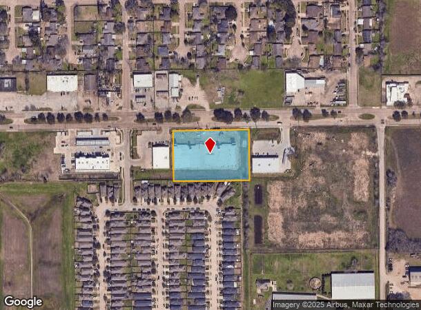
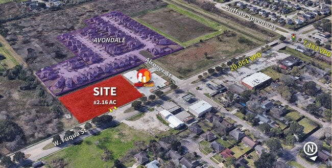
Property Record
3307 W Fuqua St, Houston, TX 77045

NEARBY LISTINGS FOR SALE OR LEASE
Property Detail
3307 W Fuqua St
1284340050001
Avondale Sec 1 Amend Par R/P Extn
Publicstorage
RES A BLK 1 AVONDALE SEC 1 AMEND PAR R/P EXTN
X
Harris
48039C0010K
Texas
2024
2.16 AC
2025
South
330600
Houston
103,950 SF
Houston-Pasadena-The Woodlands, TX
DEMOGRAPHICS near 3307 W Fuqua St
1 Mile
3 Mile
5 Mile
2024 Total Population
12,163
86,135
241,065
2029 Population
12,405
90,877
256,370
Pop Growth 2024-2029
+ 1.99%
+ 5.51%
+ 6.35%
Average Age
36
36
37
2024 Total Households
3,667
27,136
84,475
HH Growth 2024-2029
+ 1.99%
+ 5.66%
+ 6.22%
Median Household Inc
$55,872
$63,676
$65,485
Avg Household Size
3.30
3.10
2.80
2024 Avg HH Vehicles
2.00
2.00
2.00
Median Home Value
$128,319
$148,823
$202,149
Median Year Built
1982
1998
1991
Nearby Places
Map Layers
Map Styles
 Street
 Aerial
- Restaurants
- Banks
- Shops
- Fitness
- Groceries
PUBLIC TRANSPORTATION
AIRPORT
William P Hobby
DRIVE
WALK
Distance
William P Hobby
23 min
10.6 mi
George Bush Intcntl/Houston
DRIVE
WALK
Distance
George Bush Intcntl/Houston
42 min
30.7 mi
Freight Ports
Port of Houston
DRIVE
WALK
Distance
Port of Houston
27 min
16.2 mi
SALE & LEASE HISTORY
LISTING DATE
SALE/LEASE

Jan 13, 2021
For Sale
Nearby Properties
Address
Land Use
TOTAL SIZE
Lot Size
Zoning
Address
Land Use
TOTAL SIZE
Lot Size
Zoning
1,139,160 SF
75.11 AC
Address
Land Use
TOTAL SIZE
Lot Size
Zoning
15.46 AC
Address
Land Use
TOTAL SIZE
Lot Size
Zoning
567,513 SF
5.82 AC
Address
Land Use
TOTAL SIZE
Lot Size
Zoning
542,333 SF
43.95 AC
Address
Land Use
TOTAL SIZE
Lot Size
Zoning
679,822 SF
27.54 AC
Address
Land Use
TOTAL SIZE
Lot Size
Zoning
347,124 SF
Address
Land Use
TOTAL SIZE
Lot Size
Zoning
28.22 AC
Address
Land Use
TOTAL SIZE
Lot Size
Zoning
429,368 SF
27.94 AC
Address
Land Use
TOTAL SIZE
Lot Size
Zoning
181,341 SF
16.73 AC
Address
Land Use
TOTAL SIZE
Lot Size
Zoning
460,711 SF
18.98 AC
Address
Land Use
TOTAL SIZE
Lot Size
Zoning
318,524 SF
20.44 AC
Address
Land Use
TOTAL SIZE
Lot Size
Zoning
51.50 AC
Address
Land Use
TOTAL SIZE
Lot Size
Zoning
670,850 SF
35.98 AC
Address
Land Use
TOTAL SIZE
Lot Size
Zoning
447,956 SF
18.42 AC
Address
Land Use
TOTAL SIZE
Lot Size
Zoning
400,696 SF
18.88 AC
Address
Land Use
TOTAL SIZE
Lot Size
Zoning
156,214 SF
13.50 AC
0025
Address
Land Use
TOTAL SIZE
Lot Size
Zoning
423,270 SF
32.95 AC
Address
Land Use
TOTAL SIZE
Lot Size
Zoning
228,288 SF
10.32 AC
Address
Land Use
TOTAL SIZE
Lot Size
Zoning
281,889 SF
10.84 AC
Address
Land Use
TOTAL SIZE
Lot Size
Zoning
124,254 SF
22.68 AC
0002
Address
Land Use
TOTAL SIZE
Lot Size
Zoning
186,759 SF
42.60 AC
Address
Land Use
TOTAL SIZE
Lot Size
Zoning
206,777 SF
8.14 AC
Address
Land Use
TOTAL SIZE
Lot Size
Zoning
299,046 SF
Address
Land Use
TOTAL SIZE
Lot Size
Zoning
163,644 SF
8.40 AC
Address
Land Use
TOTAL SIZE
Lot Size
Zoning
231,696 SF
Address
Land Use
TOTAL SIZE
Lot Size
Zoning
264,384 SF
13.76 AC
Address
Land Use
TOTAL SIZE
Lot Size
Zoning
130,498 SF
93.44 AC
Address
Land Use
TOTAL SIZE
Lot Size
Zoning
170,092 SF
17.90 AC
Address
Land Use
TOTAL SIZE
Lot Size
Zoning
Address
Land Use
TOTAL SIZE
Lot Size
Zoning
3,108 SF
57.41 AC
The World's #1 Commercial Real Estate Marketplace
Connect with us
© 2026 CoStar Group
The information above has been obtained from sources believed reliable. While we do not doubt its accuracy we have not verified it and make no guarantee, warranty or representation about it. It is your responsibility to independently confirm its accuracy and completeness. Any projections, opinions, assumptions, or estimates used are for example only and do not represent the current or future performance of the property. The value of this transaction to you depends on tax and other factors which should be evaluated by your tax, financial, and legal advisors. You and your advisors should conduct a careful, independent investigation of the property to determine to your satisfaction the suitability of the property for your needs.