Property Record
33070 Roberts Ct, Eugene, OR 97408
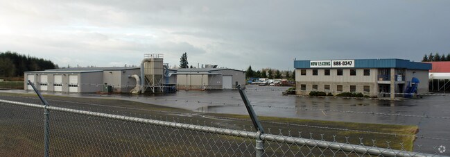

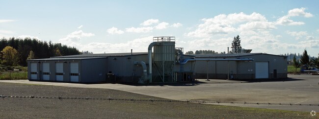
Property Detail
33070 Roberts Ct
Eugene-Springfield, OR
TL 00100
1355484
Lane
Industrialgeneral
Oregon
E40
100
A Areas with a 1% annual chance of flooding and a 26% chance of flooding over the life of a 30-year mortgage.
3.46 AC
2025
Lane County
2025
Portland
000300
NEARBY LISTINGS FOR SALE OR LEASE
DEMOGRAPHICS near 33070 Roberts Ct
1 mile
3 mile
5 mile
2025 Total Population
639
16,312
87,643
2030 Population
638
16,267
86,812
Pop Growth 2025-2030
(0.16%)
(0.28%)
(0.95%)
Average Age
42
43
42
2025 Total Households
245
6,990
37,493
HH Growth 2025-2030
0.00%
(0.40%)
(0.99%)
Median Household Inc
$92,307
$106,386
$78,402
Avg Household Size
2.60
2.30
2.30
2025 Avg HH Vehicles
2.00
2.00
2.00
Median Home Value
$581,081
$623,199
$466,221
Median Year Built
1977
1995
1979
Nearby Places
Map Layers
Map Styles
 Street
 Aerial
Transit
 Traffic
 Biking
Places
Listings with unknown addresses are not visible on the map
- Restaurants
- Banks
- Shops
- Fitness
- Groceries
PUBLIC TRANSPORTATION
COMMUTER RAIL
Eugene (Amtrak Cascades - Amtrak, Coast Starlight - Amtrak)
Drive
Walk
Distance
Eugene (Amtrak Cascades - Amtrak, Coast Starlight - Amtrak)
13 min
8.7 mi
AIRPORT
Mahlon Sweet Field
Drive
Walk
Distance
Mahlon Sweet Field
24 min
14.4 mi
Freight Ports
Port of Coos Bay, OR
Drive
Walk
Distance
Port of Coos Bay, OR
163 min
118.0 mi
Nearby Properties
Address
Land Use
TOTAL SIZE
Lot Size
Zoning
Address
Land Use
TOTAL SIZE
Lot Size
Zoning
14.39 AC
E-1
Address
Land Use
TOTAL SIZE
Lot Size
Zoning
26.13 AC
E30
Address
Land Use
TOTAL SIZE
Lot Size
Zoning
9.59 AC
R-1
Address
Land Use
TOTAL SIZE
Lot Size
Zoning
15.95 AC
Address
Land Use
TOTAL SIZE
Lot Size
Zoning
13.55 AC
CI
Address
Land Use
TOTAL SIZE
Lot Size
Zoning
14.09 AC
CI
Address
Land Use
TOTAL SIZE
Lot Size
Zoning
14.33 AC
R
Address
Land Use
TOTAL SIZE
Lot Size
Zoning
31.28 AC
R-1
Address
Land Use
TOTAL SIZE
Lot Size
Zoning
2.59 AC
LI
Address
Land Use
TOTAL SIZE
Lot Size
Zoning
16.81 AC
SG
Address
Land Use
TOTAL SIZE
Lot Size
Zoning
14.80 AC
CI
Address
Land Use
TOTAL SIZE
Lot Size
Zoning
21.88 AC
PL
Address
Land Use
TOTAL SIZE
Lot Size
Zoning
10.38 AC
E-1
Address
Land Use
TOTAL SIZE
Lot Size
Zoning
7.05 AC
E30
Address
Land Use
TOTAL SIZE
Lot Size
Zoning
Address
Land Use
TOTAL SIZE
Lot Size
Zoning
13.82 AC
CI
Address
Land Use
TOTAL SIZE
Lot Size
Zoning
5.74 AC
R-1
Address
Land Use
TOTAL SIZE
Lot Size
Zoning
2.09 AC
CC
Address
Land Use
TOTAL SIZE
Lot Size
Zoning
6.95 AC
C-2
Address
Land Use
TOTAL SIZE
Lot Size
Zoning
10.13 AC
E-1
Address
Land Use
TOTAL SIZE
Lot Size
Zoning
9.16 AC
C-2
Address
Land Use
TOTAL SIZE
Lot Size
Zoning
4.34 AC
E-1
Address
Land Use
TOTAL SIZE
Lot Size
Zoning
22.45 AC
CI
Address
Land Use
TOTAL SIZE
Lot Size
Zoning
4.94 AC
C-1
Address
Land Use
TOTAL SIZE
Lot Size
Zoning
4.67 AC
E-1
Address
Land Use
TOTAL SIZE
Lot Size
Zoning
9.79 AC
C-2
Address
Land Use
TOTAL SIZE
Lot Size
Zoning
9.79 AC
C-2
Address
Land Use
TOTAL SIZE
Lot Size
Zoning
15.85 AC
R-1
Address
Land Use
TOTAL SIZE
Lot Size
Zoning
2.40 AC
C-1
Address
Land Use
TOTAL SIZE
Lot Size
Zoning
1.33 AC
C-2
The World's #1 Commercial Real Estate Marketplace
Connect with us
© 2026 CoStar Group
The information above has been obtained from sources believed reliable. While we do not doubt its accuracy we have not verified it and make no guarantee, warranty or representation about it. It is your responsibility to independently confirm its accuracy and completeness. Any projections, opinions, assumptions, or estimates used are for example only and do not represent the current or future performance of the property. The value of this transaction to you depends on tax and other factors which should be evaluated by your tax, financial, and legal advisors. You and your advisors should conduct a careful, independent investigation of the property to determine to your satisfaction the suitability of the property for your needs.