Property Record
3316 Sandy Ridge Rd, Colfax, NC 27235

Property Detail
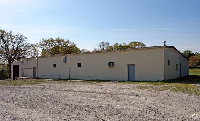
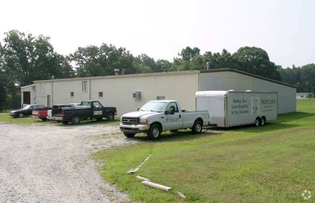
3316 Sandy Ridge Rd
0100213
3.43AC PB75-55 BYRD LO:PT 1 PL:75-55
Industrialgeneral
Guilford
LI
North Carolina
B and X Area of moderate flood hazard, usually the area between the limits of the 100-year and 500-year floods.
20
2024
3.43 AC
2025
Airport/W Guilford County
016201
Greensboro/Winston-Salem
9,586 SF
Greensboro-High Point, NC
NEARBY LISTINGS FOR SALE OR LEASE
DEMOGRAPHICS near 3316 Sandy Ridge Rd
1 mile
3 mile
5 mile
2025 Total Population
267
11,190
61,858
2030 Population
280
11,721
64,203
Pop Growth 2025-2030
+ 4.87%
+ 4.75%
+ 3.79%
Average Age
40
42
41
2025 Total Households
108
4,459
25,579
HH Growth 2025-2030
+ 4.63%
+ 5.02%
+ 3.97%
Median Household Inc
$93,228
$94,114
$84,834
Avg Household Size
2.50
2.50
2.40
2025 Avg HH Vehicles
2.00
2.00
2.00
Median Home Value
$350,000
$348,711
$311,360
Median Year Built
2007
2004
1996
Nearby Places
Map Layers
Map Styles
 Street
 Aerial
Layers
 Traffic
 Biking
Places
Listings with unknown addresses are not visible on the map
- Restaurants
- Banks
- Shops
- Fitness
- Groceries
PUBLIC TRANSPORTATION
AIRPORT
Piedmont Triad International
Drive
Walk
Distance
Piedmont Triad International
16 min
6.0 mi
SALE & LEASE HISTORY
LISTING DATE
SALE/LEASE

Jan 19, 2018
For Lease
Nearby Properties
Address
Land Use
TOTAL SIZE
Lot Size
Zoning
Address
Land Use
TOTAL SIZE
Lot Size
Zoning
274,486 SF
30.31 AC
MBP
Address
Land Use
TOTAL SIZE
Lot Size
Zoning
1,001,670 SF
94.34 AC
BI
Address
Land Use
TOTAL SIZE
Lot Size
Zoning
543,043 SF
62.40 AC
BP
Address
Land Use
TOTAL SIZE
Lot Size
Zoning
1,057,283 SF
104.31 AC
PDP
Address
Land Use
TOTAL SIZE
Lot Size
Zoning
181,444 SF
126.42 AC
PD-P
Address
Land Use
TOTAL SIZE
Lot Size
Zoning
667,440 SF
53.44 AC
BI
Address
Land Use
TOTAL SIZE
Lot Size
Zoning
186,200 SF
10.58 AC
LI
Address
Land Use
TOTAL SIZE
Lot Size
Zoning
324,931 SF
16.32 AC
PUD
Address
Land Use
TOTAL SIZE
Lot Size
Zoning
340,508 SF
15.45 AC
RM-26
Address
Land Use
TOTAL SIZE
Lot Size
Zoning
777,963 SF
133.64 AC
BI
Address
Land Use
TOTAL SIZE
Lot Size
Zoning
342,765 SF
20.98 AC
PUD
Address
Land Use
TOTAL SIZE
Lot Size
Zoning
509,216 SF
40.85 AC
LI
Address
Land Use
TOTAL SIZE
Lot Size
Zoning
229,103 SF
18.76 AC
CZ-I
Address
Land Use
TOTAL SIZE
Lot Size
Zoning
285,123 SF
22.44 AC
PUD
Address
Land Use
TOTAL SIZE
Lot Size
Zoning
428,867 SF
76.65 AC
LI
Address
Land Use
TOTAL SIZE
Lot Size
Zoning
362,708 SF
56.81 AC
LI
Address
Land Use
TOTAL SIZE
Lot Size
Zoning
254,290 SF
21.12 AC
RM-12
Address
Land Use
TOTAL SIZE
Lot Size
Zoning
350,268 SF
30.53 AC
BI
Address
Land Use
TOTAL SIZE
Lot Size
Zoning
180,568 SF
0.01 AC
AR
Address
Land Use
TOTAL SIZE
Lot Size
Zoning
341,000 SF
29.55 AC
LI
Address
Land Use
TOTAL SIZE
Lot Size
Zoning
299,786 SF
24.49 AC
PDP
Address
Land Use
TOTAL SIZE
Lot Size
Zoning
543,123 SF
24.66 AC
LI
Address
Land Use
TOTAL SIZE
Lot Size
Zoning
275,040 SF
28 AC
BI
Address
Land Use
TOTAL SIZE
Lot Size
Zoning
217,000 SF
16.58 AC
LI
Address
Land Use
TOTAL SIZE
Lot Size
Zoning
267,381 SF
18.98 AC
RM-12
Address
Land Use
TOTAL SIZE
Lot Size
Zoning
161,975 SF
20.66 AC
BP
Address
Land Use
TOTAL SIZE
Lot Size
Zoning
176,000 SF
12.95 AC
CZ-I
Address
Land Use
TOTAL SIZE
Lot Size
Zoning
208,936 SF
22.88 AC
LI
Address
Land Use
TOTAL SIZE
Lot Size
Zoning
134,781 SF
140.63 AC
AR
Address
Land Use
TOTAL SIZE
Lot Size
Zoning
244,562 SF
29.92 AC
BI
The World's #1 Commercial Real Estate Marketplace
Connect with us
© 2026 CoStar Group
The information above has been obtained from sources believed reliable. While we do not doubt its accuracy we have not verified it and make no guarantee, warranty or representation about it. It is your responsibility to independently confirm its accuracy and completeness. Any projections, opinions, assumptions, or estimates used are for example only and do not represent the current or future performance of the property. The value of this transaction to you depends on tax and other factors which should be evaluated by your tax, financial, and legal advisors. You and your advisors should conduct a careful, independent investigation of the property to determine to your satisfaction the suitability of the property for your needs.