Property Record
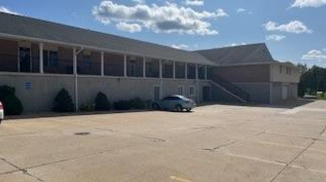
3310 W Chartwell Rd, Peoria, IL 61614

Current Lease Availabilities
NEARBY LISTINGS FOR SALE OR LEASE
Property Detail
3310 W Chartwell Rd
Peoria
Northgate Park
Peoria, IL
NORTHGATE PARK SEC 2 SE 1/4 SEC 12-9-7E LOT 31 (EXC BEG NW COR LOT 31: TH ELY ALG CURVE 88.8 E 40.29 S 268.95 W 127.41 N ALG W LN LOT 31 TO POB)
13/12/479/003
Peoria
Commercialnec
Illinois
2024
31
2024
0.86 AC
003104
North Peoria
DEMOGRAPHICS near 3310 W Chartwell Rd
1 Mile
3 Mile
5 Mile
2024 Total Population
8,123
40,749
95,875
2029 Population
7,842
39,584
93,233
Pop Growth 2024-2029
(3.46%)
(2.86%)
(2.76%)
Average Age
40
42
40
2024 Total Households
3,752
18,181
40,757
HH Growth 2024-2029
(3.65%)
(3.01%)
(2.96%)
Median Household Inc
$58,727
$62,952
$60,135
Avg Household Size
2.10
2.10
2.20
2024 Avg HH Vehicles
2.00
2.00
2.00
Median Home Value
$159,457
$164,062
$148,957
Median Year Built
1978
1975
1969
Nearby Places
Map Layers
Map Styles
 Street
 Aerial
- Restaurants
- Banks
- Shops
- Fitness
- Groceries
PUBLIC TRANSPORTATION
AIRPORT
General Downing - Peoria International
DRIVE
WALK
Distance
General Downing - Peoria International
18 min
11.4 mi
Nearby Properties
Address
Land Use
TOTAL SIZE
Lot Size
Zoning
Address
Land Use
TOTAL SIZE
Lot Size
Zoning
46.02 AC
Address
Land Use
TOTAL SIZE
Lot Size
Zoning
7.75 AC
Address
Land Use
TOTAL SIZE
Lot Size
Zoning
47.89 AC
Address
Land Use
TOTAL SIZE
Lot Size
Zoning
8.17 AC
Address
Land Use
TOTAL SIZE
Lot Size
Zoning
20.08 AC
Address
Land Use
TOTAL SIZE
Lot Size
Zoning
22.10 AC
Address
Land Use
TOTAL SIZE
Lot Size
Zoning
28.05 AC
Address
Land Use
TOTAL SIZE
Lot Size
Zoning
17.65 AC
Address
Land Use
TOTAL SIZE
Lot Size
Zoning
6.05 AC
Address
Land Use
TOTAL SIZE
Lot Size
Zoning
12.22 AC
Address
Land Use
TOTAL SIZE
Lot Size
Zoning
18.07 AC
Address
Land Use
TOTAL SIZE
Lot Size
Zoning
21.78 AC
Address
Land Use
TOTAL SIZE
Lot Size
Zoning
20.51 AC
Address
Land Use
TOTAL SIZE
Lot Size
Zoning
10.41 AC
Address
Land Use
TOTAL SIZE
Lot Size
Zoning
1.32 AC
Address
Land Use
TOTAL SIZE
Lot Size
Zoning
7.02 AC
Address
Land Use
TOTAL SIZE
Lot Size
Zoning
Address
Land Use
TOTAL SIZE
Lot Size
Zoning
17.21 AC
Address
Land Use
TOTAL SIZE
Lot Size
Zoning
17.08 AC
Address
Land Use
TOTAL SIZE
Lot Size
Zoning
8.74 AC
Address
Land Use
TOTAL SIZE
Lot Size
Zoning
Address
Land Use
TOTAL SIZE
Lot Size
Zoning
16.70 AC
Address
Land Use
TOTAL SIZE
Lot Size
Zoning
Address
Land Use
TOTAL SIZE
Lot Size
Zoning
Address
Land Use
TOTAL SIZE
Lot Size
Zoning
0.60 AC
Address
Land Use
TOTAL SIZE
Lot Size
Zoning
18.21 AC
Address
Land Use
TOTAL SIZE
Lot Size
Zoning
20.51 AC
Address
Land Use
TOTAL SIZE
Lot Size
Zoning
26.61 AC
Address
Land Use
TOTAL SIZE
Lot Size
Zoning
2.42 AC
Address
Land Use
TOTAL SIZE
Lot Size
Zoning
14.34 AC
The World's #1 Commercial Real Estate Marketplace
Connect with us
© 2025 CoStar Group
The information above has been obtained from sources believed reliable. While we do not doubt its accuracy we have not verified it and make no guarantee, warranty or representation about it. It is your responsibility to independently confirm its accuracy and completeness. Any projections, opinions, assumptions, or estimates used are for example only and do not represent the current or future performance of the property. The value of this transaction to you depends on tax and other factors which should be evaluated by your tax, financial, and legal advisors. You and your advisors should conduct a careful, independent investigation of the property to determine to your satisfaction the suitability of the property for your needs.