Property Record
3308 Watson Rd, Saint Louis, MO 63139
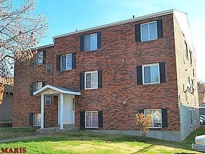

Property Detail
3308 Watson Rd
4765-00-0610-0
C. B. 4765 WATSON RD 70 FT X 125 FT MCDERMOTTS-WATSON RD ADDN LOT 3 S-4
Multifamilydwelling
ST. LOUIS CITY
F
Missouri
B and X Area of moderate flood hazard, usually the area between the limits of the 100-year and 500-year floods.
3
2024
0.20 AC
2025
Lindenwood Park
103700
St. Louis
5,600 SF
St. Louis, MO-IL
NEARBY LISTINGS FOR SALE OR LEASE
DEMOGRAPHICS near 3308 Watson Rd
1 mile
3 mile
5 mile
2025 Total Population
15,021
129,206
360,359
2030 Population
13,738
122,490
348,191
Pop Growth 2025-2030
(8.54%)
(5.20%)
(3.38%)
Average Age
42
40
40
2025 Total Households
7,704
61,995
165,687
HH Growth 2025-2030
(8.94%)
(5.80%)
(3.90%)
Median Household Inc
$81,269
$77,368
$74,229
Avg Household Size
1.90
2.00
2.00
2025 Avg HH Vehicles
2.00
2.00
1.00
Median Home Value
$240,610
$257,006
$268,323
Median Year Built
1948
1948
1948
Nearby Places
Map Layers
Map Styles
 Street
 Aerial
Layers
 Traffic
 Biking
Places
Listings with unknown addresses are not visible on the map
- Restaurants
- Banks
- Shops
- Fitness
- Groceries
PUBLIC TRANSPORTATION
COMMUTER RAIL
Shrewsbury-Lansdowne (Shrewsbury-Lansdowne I-44 Emerson Park - St. Louis MetroLink (MetroLink))
Drive
Walk
Distance
Shrewsbury-Lansdowne (Shrewsbury-Lansdowne I-44 Emerson Park - St. Louis MetroLink (MetroLink))
5 min
1.8 mi
Maplewood-Manchester (Shrewsbury-Lansdowne I-44 Emerson Park - St. Louis MetroLink (MetroLink))
Drive
Walk
Distance
Maplewood-Manchester (Shrewsbury-Lansdowne I-44 Emerson Park - St. Louis MetroLink (MetroLink))
7 min
2.5 mi
AIRPORT
St Louis Lambert International
Drive
Walk
Distance
St Louis Lambert International
23 min
14.6 mi
Scott AFB/Midamerica St Louis
Drive
Walk
Distance
Scott AFB/Midamerica St Louis
49 min
32.3 mi
Nearby Properties
Address
Land Use
TOTAL SIZE
Lot Size
Zoning
Address
Land Use
TOTAL SIZE
Lot Size
Zoning
5.61 AC
A
Address
Land Use
TOTAL SIZE
Lot Size
Zoning
136.92 AC
AI
Address
Land Use
TOTAL SIZE
Lot Size
Zoning
833,982 SF
18.70 AC
GB
Address
Land Use
TOTAL SIZE
Lot Size
Zoning
52,556 SF
68.80 AC
14R-2
Address
Land Use
TOTAL SIZE
Lot Size
Zoning
229.57 AC
B
Address
Land Use
TOTAL SIZE
Lot Size
Zoning
7,780 SF
15.61 AC
14R-2
Address
Land Use
TOTAL SIZE
Lot Size
Zoning
844,350 SF
63.08 AC
64A1
Address
Land Use
TOTAL SIZE
Lot Size
Zoning
57.77 AC
A
Address
Land Use
TOTAL SIZE
Lot Size
Zoning
6.05 AC
J
Address
Land Use
TOTAL SIZE
Lot Size
Zoning
306,459 SF
4.79 AC
H
Address
Land Use
TOTAL SIZE
Lot Size
Zoning
358,243 SF
3.02 AC
H
Address
Land Use
TOTAL SIZE
Lot Size
Zoning
559,752 SF
24.37 AC
53R-3
Address
Land Use
TOTAL SIZE
Lot Size
Zoning
322,742 SF
15.04 AC
9LID
Address
Land Use
TOTAL SIZE
Lot Size
Zoning
175,698 SF
15.92 AC
9PD
Address
Land Use
TOTAL SIZE
Lot Size
Zoning
117,270 SF
0.21 AC
49C2
Address
Land Use
TOTAL SIZE
Lot Size
Zoning
212,406 SF
21.42 AC
AB
Address
Land Use
TOTAL SIZE
Lot Size
Zoning
198,556 SF
10.12 AC
A
Address
Land Use
TOTAL SIZE
Lot Size
Zoning
44.38 AC
R1
Address
Land Use
TOTAL SIZE
Lot Size
Zoning
187,188 SF
6.83 AC
G
Address
Land Use
TOTAL SIZE
Lot Size
Zoning
158,767 SF
17.01 AC
64A3
Address
Land Use
TOTAL SIZE
Lot Size
Zoning
39,712 SF
30.49 AC
R1
Address
Land Use
TOTAL SIZE
Lot Size
Zoning
2,375 SF
8.19 AC
14R-5
Address
Land Use
TOTAL SIZE
Lot Size
Zoning
3,024 SF
4.73 AC
64A3
Address
Land Use
TOTAL SIZE
Lot Size
Zoning
8,981 SF
10.81 AC
64A3
Address
Land Use
TOTAL SIZE
Lot Size
Zoning
22.44 AC
A
Address
Land Use
TOTAL SIZE
Lot Size
Zoning
432,844 SF
5.08 AC
JK
Address
Land Use
TOTAL SIZE
Lot Size
Zoning
256,565 SF
3.70 AC
G
Address
Land Use
TOTAL SIZE
Lot Size
Zoning
227,634 SF
11.28 AC
49C2
Address
Land Use
TOTAL SIZE
Lot Size
Zoning
206,280 SF
2.85 AC
9PD
Address
Land Use
TOTAL SIZE
Lot Size
Zoning
48,236 SF
16.23 AC
64A1
The World's #1 Commercial Real Estate Marketplace
Connect with us
© 2026 CoStar Group
The information above has been obtained from sources believed reliable. While we do not doubt its accuracy we have not verified it and make no guarantee, warranty or representation about it. It is your responsibility to independently confirm its accuracy and completeness. Any projections, opinions, assumptions, or estimates used are for example only and do not represent the current or future performance of the property. The value of this transaction to you depends on tax and other factors which should be evaluated by your tax, financial, and legal advisors. You and your advisors should conduct a careful, independent investigation of the property to determine to your satisfaction the suitability of the property for your needs.