Property Record
331 Gallatin Pike N, Madison, TN 37115
NEARBY LISTINGS FOR SALE OR LEASE
Property Detail
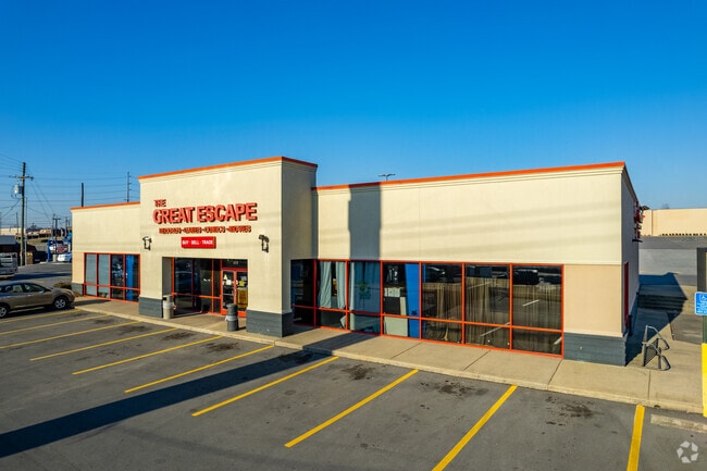
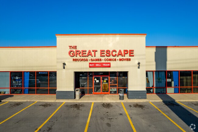
331 Gallatin Pike N
042-12-0-073
N SIDE OLD HICKORY BLVD W OF GALLATIN PK
Stripcommercialcenter
Davidson
X
Tennessee
47037C0139H
14.35 AC
2025
North Nashville
2025
Nashville
010701
Nashville-Davidson--Murfreesboro--Franklin, TN
106,565 SF
DEMOGRAPHICS near 331 Gallatin Pike N
1 Mile
3 Mile
5 Mile
2024 Total Population
11,995
52,445
115,933
2029 Population
11,979
52,230
116,190
Pop Growth 2024-2029
(0.13%)
(0.41%)
+ 0.22%
Average Age
40
40
39
2024 Total Households
5,239
22,106
48,735
HH Growth 2024-2029
(0.61%)
(0.74%)
(0.10%)
Median Household Inc
$54,894
$56,430
$59,349
Avg Household Size
2.20
2.30
2.30
2024 Avg HH Vehicles
2.00
2.00
2.00
Median Home Value
$241,219
$272,009
$300,909
Median Year Built
1973
1979
1979
Nearby Places
Map Layers
Map Styles
 Street
 Aerial
- Restaurants
- Banks
- Shops
- Fitness
- Groceries
PUBLIC TRANSPORTATION
COMMUTER RAIL
Riverfront (East Corridor Line - Tennessee Regional Transportation Authority Music City Star (Music City Star))
DRIVE
WALK
Distance
Riverfront (East Corridor Line - Tennessee Regional Transportation Authority Music City Star (Music City Star))
15 min
9.8 mi
AIRPORT
Nashville International
DRIVE
WALK
Distance
Nashville International
23 min
14.3 mi
Nearby Properties
Address
Land Use
TOTAL SIZE
Lot Size
Zoning
Address
Land Use
TOTAL SIZE
Lot Size
Zoning
43,022 SF
17.02 AC
MULTIZONE
Address
Land Use
TOTAL SIZE
Lot Size
Zoning
26,434 SF
12.86 AC
RM20
Address
Land Use
TOTAL SIZE
Lot Size
Zoning
27,585 SF
18.20 AC
SP
Address
Land Use
TOTAL SIZE
Lot Size
Zoning
34,160 SF
9.20 AC
R10
Address
Land Use
TOTAL SIZE
Lot Size
Zoning
363,125 SF
51.28 AC
MULTI-ZONE
Address
Land Use
TOTAL SIZE
Lot Size
Zoning
29,064 SF
15.11 AC
MULTIZONE
Address
Land Use
TOTAL SIZE
Lot Size
Zoning
11,088 SF
21.28 AC
RS7.5
Address
Land Use
TOTAL SIZE
Lot Size
Zoning
17,292 SF
12.35 AC
RM20
Address
Land Use
TOTAL SIZE
Lot Size
Zoning
30,534 SF
19.77 AC
SP
Address
Land Use
TOTAL SIZE
Lot Size
Zoning
336,784 SF
41.54 AC
IR
Address
Land Use
TOTAL SIZE
Lot Size
Zoning
154,143 SF
8.88 AC
OG
Address
Land Use
TOTAL SIZE
Lot Size
Zoning
20.60 AC
RS10
Address
Land Use
TOTAL SIZE
Lot Size
Zoning
17,214 SF
40.52 AC
RM9
Address
Land Use
TOTAL SIZE
Lot Size
Zoning
6,120 SF
17.46 AC
R10
Address
Land Use
TOTAL SIZE
Lot Size
Zoning
162,261 SF
6.20 AC
RM40
Address
Land Use
TOTAL SIZE
Lot Size
Zoning
13,950 SF
17.60 AC
R8
Address
Land Use
TOTAL SIZE
Lot Size
Zoning
3,312 SF
33.03 AC
IR
Address
Land Use
TOTAL SIZE
Lot Size
Zoning
191,221 SF
0.64 AC
MULTIZONE
Address
Land Use
TOTAL SIZE
Lot Size
Zoning
146,323 SF
4.48 AC
RM40
Address
Land Use
TOTAL SIZE
Lot Size
Zoning
34,752 SF
19.09 AC
CS
Address
Land Use
TOTAL SIZE
Lot Size
Zoning
93,000 SF
16.44 AC
IR
Address
Land Use
TOTAL SIZE
Lot Size
Zoning
23,010 SF
23.52 AC
RS10
Address
Land Use
TOTAL SIZE
Lot Size
Zoning
112,056 SF
40.15 AC
MULTIZONE
Address
Land Use
TOTAL SIZE
Lot Size
Zoning
4,578 SF
17.98 AC
R15
Address
Land Use
TOTAL SIZE
Lot Size
Zoning
22,090 SF
9.18 AC
CA
Address
Land Use
TOTAL SIZE
Lot Size
Zoning
26,610 SF
6.66 AC
RS20
Address
Land Use
TOTAL SIZE
Lot Size
Zoning
3,864 SF
4.05 AC
RS5
Address
Land Use
TOTAL SIZE
Lot Size
Zoning
17,500 SF
17.56 AC
SCR
Address
Land Use
TOTAL SIZE
Lot Size
Zoning
49,752 SF
5.36 AC
RS20
Address
Land Use
TOTAL SIZE
Lot Size
Zoning
10,336 SF
17.70 AC
6ZZ
The World's #1 Commercial Real Estate Marketplace
Connect with us
© 2025 CoStar Group
The information above has been obtained from sources believed reliable. While we do not doubt its accuracy we have not verified it and make no guarantee, warranty or representation about it. It is your responsibility to independently confirm its accuracy and completeness. Any projections, opinions, assumptions, or estimates used are for example only and do not represent the current or future performance of the property. The value of this transaction to you depends on tax and other factors which should be evaluated by your tax, financial, and legal advisors. You and your advisors should conduct a careful, independent investigation of the property to determine to your satisfaction the suitability of the property for your needs.