Property Record
331 Miller St, Benton Harbor, MI 49022


Current Lease Availabilities
NEARBY LISTINGS FOR SALE OR LEASE
Property Detail
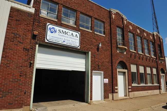
331 Miller St
Niles-Benton Harbor, MI
Renaissance Zone Sub
11-54-5130-0045-03-6
LOTS 1 THRU 12 INCL BLK 6 MORTON & RIFORD'S ADD TO CITY OF BENTON HARBOR WHICH INCLUDES THAT PT OF THE SLY 1/2 OF VACATED MILLER ST & THE VACATED ALLEY & THAT PT OF THE NLY 1/2 OF VACATED RIFORD ST & THAT PART OF THE ELY 1/2 OF VACATED THIRD ST LYING
Warehouse
Berrien
AE
Michigan
26021C0102D
1-12
2024
3.17 AC
2025
Michigan Southwest Area
000300
Other Market Areas
98,499 SF
DEMOGRAPHICS near 331 Miller St
1 Mile
3 Mile
5 Mile
2024 Total Population
5,873
29,617
40,837
2029 Population
5,947
29,387
40,305
Pop Growth 2024-2029
+ 1.26%
(0.78%)
(1.30%)
Average Age
35
38
40
2024 Total Households
2,206
12,214
17,113
HH Growth 2024-2029
+ 0.95%
(1.15%)
(1.64%)
Median Household Inc
$26,794
$35,068
$44,247
Avg Household Size
2.50
2.30
2.30
2024 Avg HH Vehicles
1.00
1.00
2.00
Median Home Value
$101,626
$160,946
$181,766
Median Year Built
1964
1958
1961
Nearby Places
Map Layers
Map Styles
 Street
 Aerial
- Restaurants
- Banks
- Shops
- Fitness
- Groceries
PUBLIC TRANSPORTATION
COMMUTER RAIL
St. Joseph-Benton Harbor Amtrak Station (Pere Marquette - Amtrak)
DRIVE
WALK
Distance
St. Joseph-Benton Harbor Amtrak Station (Pere Marquette - Amtrak)
6 min
2.4 mi
AIRPORT
South Bend International
DRIVE
WALK
Distance
South Bend International
51 min
37.0 mi
Freight Ports
Port Milwaukee
DRIVE
WALK
Distance
Port Milwaukee
224 min
184.5 mi
Nearby Properties
Address
Land Use
TOTAL SIZE
Lot Size
Zoning
Address
Land Use
TOTAL SIZE
Lot Size
Zoning
313,588 SF
11.48 AC
DISTRICT A
Address
Land Use
TOTAL SIZE
Lot Size
Zoning
365,903 SF
95.25 AC
Address
Land Use
TOTAL SIZE
Lot Size
Zoning
216,232 SF
Address
Land Use
TOTAL SIZE
Lot Size
Zoning
89,062 SF
1.60 AC
W
Address
Land Use
TOTAL SIZE
Lot Size
Zoning
99,468 SF
10.07 AC
DISTRICT G
Address
Land Use
TOTAL SIZE
Lot Size
Zoning
202,713 SF
14.23 AC
CO-A
Address
Land Use
TOTAL SIZE
Lot Size
Zoning
296,788 SF
34 AC
D1 COMM
Address
Land Use
TOTAL SIZE
Lot Size
Zoning
258,549 SF
17.20 AC
C MULTI
Address
Land Use
TOTAL SIZE
Lot Size
Zoning
69,750 SF
0.47 AC
D
Address
Land Use
TOTAL SIZE
Lot Size
Zoning
112,503 SF
4.30 AC
C MULTI FA
Address
Land Use
TOTAL SIZE
Lot Size
Zoning
86,000 SF
22.38 AC
D1 COMM
Address
Land Use
TOTAL SIZE
Lot Size
Zoning
93,032 SF
0.51 AC
D
Address
Land Use
TOTAL SIZE
Lot Size
Zoning
75,050 SF
5.33 AC
NONE
Address
Land Use
TOTAL SIZE
Lot Size
Zoning
108,300 SF
12.36 AC
DISTRICT F
Address
Land Use
TOTAL SIZE
Lot Size
Zoning
82,567 SF
1.74 AC
D
Address
Land Use
TOTAL SIZE
Lot Size
Zoning
90,000 SF
7.62 AC
W
Address
Land Use
TOTAL SIZE
Lot Size
Zoning
65,584 SF
6.52 AC
CO-A
Address
Land Use
TOTAL SIZE
Lot Size
Zoning
84,732 SF
4.19 AC
C MULTI FA
Address
Land Use
TOTAL SIZE
Lot Size
Zoning
40,063 SF
9.78 AC
DISTRICT G
Address
Land Use
TOTAL SIZE
Lot Size
Zoning
70,617 SF
12 AC
E RESTRICT
Address
Land Use
TOTAL SIZE
Lot Size
Zoning
103,591 SF
8.77 AC
D1 COMM
Address
Land Use
TOTAL SIZE
Lot Size
Zoning
69,484 SF
8.08 AC
C MULTI
Address
Land Use
TOTAL SIZE
Lot Size
Zoning
18.05 AC
D1 COMM
Address
Land Use
TOTAL SIZE
Lot Size
Zoning
151,462 SF
9.96 AC
DISTRICT F
Address
Land Use
TOTAL SIZE
Lot Size
Zoning
71,755 SF
11.06 AC
Address
Land Use
TOTAL SIZE
Lot Size
Zoning
55,753 SF
6 AC
DISTRICT D
Address
Land Use
TOTAL SIZE
Lot Size
Zoning
142,200 SF
18 AC
DISTRICT G
Address
Land Use
TOTAL SIZE
Lot Size
Zoning
48,756 SF
3.33 AC
DISTRICT A
Address
Land Use
TOTAL SIZE
Lot Size
Zoning
34,384 SF
2.76 AC
DISTRICT D
Address
Land Use
TOTAL SIZE
Lot Size
Zoning
21,600 SF
The World's #1 Commercial Real Estate Marketplace
Connect with us
© 2025 CoStar Group
The information above has been obtained from sources believed reliable. While we do not doubt its accuracy we have not verified it and make no guarantee, warranty or representation about it. It is your responsibility to independently confirm its accuracy and completeness. Any projections, opinions, assumptions, or estimates used are for example only and do not represent the current or future performance of the property. The value of this transaction to you depends on tax and other factors which should be evaluated by your tax, financial, and legal advisors. You and your advisors should conduct a careful, independent investigation of the property to determine to your satisfaction the suitability of the property for your needs.