Property Record
331 Route 9W, Glenmont, NY 12077

NEARBY LISTINGS FOR SALE OR LEASE
-
-
View all Glenmont listings for sale on LoopNet.com
Property Detail
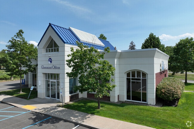
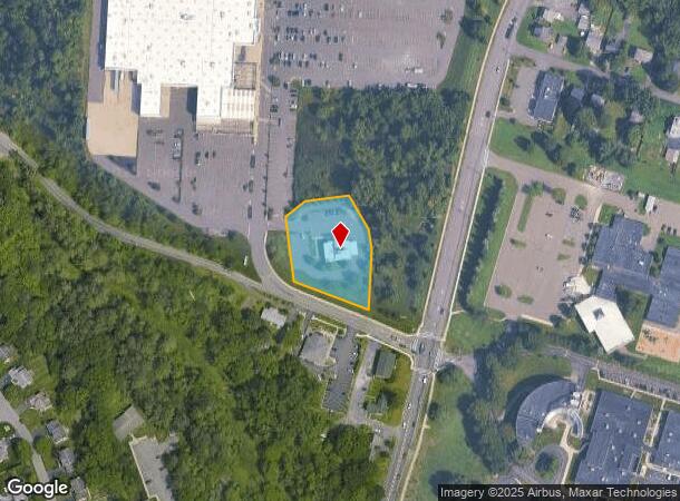
331 Route 9W
012200-086-000-0002-021-002-0000
Interior Lot Division Plan For Bethlehem
Financialbuilding
Albany
X
New York
36001C0306D
21.002
2025
1.12 AC
2024
W Outer Albany County
014201
Albany/Schenectady/Troy
3,165 SF
Albany-Schenectady-Troy, NY
DEMOGRAPHICS near 331 Route 9W
1 Mile
3 Mile
5 Mile
2024 Total Population
3,275
39,943
139,062
2029 Population
3,268
39,409
137,447
Pop Growth 2024-2029
(0.21%)
(1.34%)
(1.16%)
Average Age
42
41
39
2024 Total Households
1,332
16,353
60,942
HH Growth 2024-2029
(0.23%)
(1.38%)
(1.17%)
Median Household Inc
$107,128
$82,193
$68,010
Avg Household Size
2.40
2.30
2.10
2024 Avg HH Vehicles
2.00
2.00
1.00
Median Home Value
$309,770
$261,112
$246,346
Median Year Built
1982
1958
1956
Nearby Places
Map Layers
Map Styles
 Street
 Aerial
- Restaurants
- Banks
- Shops
- Fitness
- Groceries
PUBLIC TRANSPORTATION
COMMUTER RAIL
DRIVE
WALK
Distance
11 min
4.7 mi
AIRPORT
Albany International
DRIVE
WALK
Distance
Albany International
28 min
15.1 mi
Freight Ports
Albany, NY Port
DRIVE
WALK
Distance
Albany, NY Port
7 min
3.0 mi
Nearby Properties
Address
Land Use
TOTAL SIZE
Lot Size
Zoning
Address
Land Use
TOTAL SIZE
Lot Size
Zoning
33.88 AC
I2
Address
Land Use
TOTAL SIZE
Lot Size
Zoning
83.50 AC
Address
Land Use
TOTAL SIZE
Lot Size
Zoning
133,984 SF
205.20 AC
C2
Address
Land Use
TOTAL SIZE
Lot Size
Zoning
191.95 AC
LC
Address
Land Use
TOTAL SIZE
Lot Size
Zoning
5,248 SF
200.90 AC
LC
Address
Land Use
TOTAL SIZE
Lot Size
Zoning
78,458 SF
28.70 AC
R1B
Address
Land Use
TOTAL SIZE
Lot Size
Zoning
104,077 SF
6.64 AC
B-2
Address
Land Use
TOTAL SIZE
Lot Size
Zoning
26,010 SF
14.65 AC
CO
Address
Land Use
TOTAL SIZE
Lot Size
Zoning
161,972 SF
26.62 AC
OI
Address
Land Use
TOTAL SIZE
Lot Size
Zoning
96,000 SF
3.92 AC
CO
Address
Land Use
TOTAL SIZE
Lot Size
Zoning
5,776 SF
90.90 AC
M1
Address
Land Use
TOTAL SIZE
Lot Size
Zoning
17,440 SF
4.10 AC
R2A
Address
Land Use
TOTAL SIZE
Lot Size
Zoning
96,554 SF
18.50 AC
R1B
Address
Land Use
TOTAL SIZE
Lot Size
Zoning
73,458 SF
7.90 AC
CO
Address
Land Use
TOTAL SIZE
Lot Size
Zoning
27,612 SF
11.60 AC
M1
Address
Land Use
TOTAL SIZE
Lot Size
Zoning
100,176 SF
3.23 AC
C1
Address
Land Use
TOTAL SIZE
Lot Size
Zoning
58.90 AC
LC
Address
Land Use
TOTAL SIZE
Lot Size
Zoning
20.10 AC
M1
Address
Land Use
TOTAL SIZE
Lot Size
Zoning
203,781 SF
39.30 AC
C
Address
Land Use
TOTAL SIZE
Lot Size
Zoning
0.01 AC
I
Address
Land Use
TOTAL SIZE
Lot Size
Zoning
40,888 SF
31.40 AC
M1
Address
Land Use
TOTAL SIZE
Lot Size
Zoning
115,428 SF
5.90 AC
R3B
Address
Land Use
TOTAL SIZE
Lot Size
Zoning
44,572 SF
2.80 AC
CO
Address
Land Use
TOTAL SIZE
Lot Size
Zoning
260,120 SF
9 AC
CO
Address
Land Use
TOTAL SIZE
Lot Size
Zoning
7,472 SF
18.40 AC
PDD
Address
Land Use
TOTAL SIZE
Lot Size
Zoning
63,306 SF
2.81 AC
CO
Address
Land Use
TOTAL SIZE
Lot Size
Zoning
204,860 SF
26.40 AC
CR
Address
Land Use
TOTAL SIZE
Lot Size
Zoning
57,830 SF
2.10 AC
CO
Address
Land Use
TOTAL SIZE
Lot Size
Zoning
83,312 SF
0.68 AC
CM
Address
Land Use
TOTAL SIZE
Lot Size
Zoning
45,898 SF
12.91 AC
CH
The World's #1 Commercial Real Estate Marketplace
Connect with us
© 2026 CoStar Group
The information above has been obtained from sources believed reliable. While we do not doubt its accuracy we have not verified it and make no guarantee, warranty or representation about it. It is your responsibility to independently confirm its accuracy and completeness. Any projections, opinions, assumptions, or estimates used are for example only and do not represent the current or future performance of the property. The value of this transaction to you depends on tax and other factors which should be evaluated by your tax, financial, and legal advisors. You and your advisors should conduct a careful, independent investigation of the property to determine to your satisfaction the suitability of the property for your needs.