Property Record
331 Scarlet Blvd, Oldsmar, FL 34677
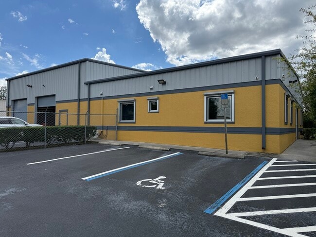


Property Detail
331 Scarlet Blvd
Tampa-St. Petersburg-Clearwater, FL
MEARS COMMERCE CENTER PHASE 2A LOT 4 AKA MEARS COMMERCE CENTER II LOT 11
23-28-16-56990-000-0040
Pinellas
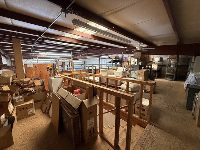
Warehouse
Florida
AE The base floodplain where base flood elevations are provided. AE Zones are now used on new format FIRMs instead of A1-A30 Zones.
4,11
2024
0.41 AC
2025
North Pinellas
027320
Tampa/St Petersburg
5,850 SF
NEARBY LISTINGS FOR SALE OR LEASE
DEMOGRAPHICS near 331 Scarlet Blvd
1 mile
3 mile
5 mile
2025 Total Population
7,315
50,378
163,030
2030 Population
7,201
50,276
164,908
Pop Growth 2025-2030
(1.56%)
(0.20%)
+ 1.15%
Average Age
40
45
46
2025 Total Households
2,772
21,874
71,882
HH Growth 2025-2030
(1.88%)
(0.40%)
+ 0.88%
Median Household Inc
$87,399
$86,125
$84,079
Avg Household Size
2.60
2.20
2.20
2025 Avg HH Vehicles
2.00
2.00
2.00
Median Home Value
$441,344
$449,258
$431,933
Median Year Built
1986
1985
1985
Nearby Places
Map Layers
Map Styles
 Street
 Aerial
Layers
 Traffic
 Biking
Places
Listings with unknown addresses are not visible on the map
- Restaurants
- Banks
- Shops
- Fitness
- Groceries
PUBLIC TRANSPORTATION
AIRPORT
St Pete-Clearwater International
Drive
Walk
Distance
St Pete-Clearwater International
19 min
11.4 mi
Tampa International
Drive
Walk
Distance
Tampa International
24 min
12.8 mi
Freight Ports
Port of Tampa Bay
Drive
Walk
Distance
Port of Tampa Bay
38 min
21.3 mi
SALE & LEASE HISTORY
LISTING DATE
SALE/LEASE

Sep 24, 2025
For Lease
Nearby Properties
Address
Land Use
TOTAL SIZE
Lot Size
Zoning
Address
Land Use
TOTAL SIZE
Lot Size
Zoning
661,982 SF
19.26 AC
Address
Land Use
TOTAL SIZE
Lot Size
Zoning
462,206 SF
30.26 AC
RPD5
Address
Land Use
TOTAL SIZE
Lot Size
Zoning
358,185 SF
41.27 AC
PD
Address
Land Use
TOTAL SIZE
Lot Size
Zoning
473,742 SF
20.84 AC
Address
Land Use
TOTAL SIZE
Lot Size
Zoning
356,262 SF
15.48 AC
Address
Land Use
TOTAL SIZE
Lot Size
Zoning
305,687 SF
31.48 AC
PD
Address
Land Use
TOTAL SIZE
Lot Size
Zoning
417,535 SF
42.47 AC
Address
Land Use
TOTAL SIZE
Lot Size
Zoning
326,008 SF
53.12 AC
Address
Land Use
TOTAL SIZE
Lot Size
Zoning
302,915 SF
55.33 AC
RPD75
Address
Land Use
TOTAL SIZE
Lot Size
Zoning
427,299 SF
80.21 AC
PD
Address
Land Use
TOTAL SIZE
Lot Size
Zoning
236,972 SF
19.07 AC
Address
Land Use
TOTAL SIZE
Lot Size
Zoning
286,650 SF
23.36 AC
RPD5
Address
Land Use
TOTAL SIZE
Lot Size
Zoning
311,117 SF
16.96 AC
Address
Land Use
TOTAL SIZE
Lot Size
Zoning
241,867 SF
19.54 AC
Address
Land Use
TOTAL SIZE
Lot Size
Zoning
233,620 SF
14.13 AC
RPD5
Address
Land Use
TOTAL SIZE
Lot Size
Zoning
304,142 SF
12.19 AC
RPD5
Address
Land Use
TOTAL SIZE
Lot Size
Zoning
258,403 SF
10.62 AC
RPD5
Address
Land Use
TOTAL SIZE
Lot Size
Zoning
160,827 SF
20.22 AC
AE
Address
Land Use
TOTAL SIZE
Lot Size
Zoning
173,673 SF
13.77 AC
PD
Address
Land Use
TOTAL SIZE
Lot Size
Zoning
294,022 SF
15.75 AC
RPD5
Address
Land Use
TOTAL SIZE
Lot Size
Zoning
188,940 SF
24.78 AC
PD
Address
Land Use
TOTAL SIZE
Lot Size
Zoning
177,360 SF
9.28 AC
Address
Land Use
TOTAL SIZE
Lot Size
Zoning
145,000 SF
1.26 AC
Address
Land Use
TOTAL SIZE
Lot Size
Zoning
126,644 SF
19.09 AC
Address
Land Use
TOTAL SIZE
Lot Size
Zoning
575,565 SF
335.60 AC
PD
Address
Land Use
TOTAL SIZE
Lot Size
Zoning
220,103 SF
28.40 AC
Address
Land Use
TOTAL SIZE
Lot Size
Zoning
14,334 SF
117.55 AC
Address
Land Use
TOTAL SIZE
Lot Size
Zoning
153,134 SF
6.52 AC
AE
Address
Land Use
TOTAL SIZE
Lot Size
Zoning
198,800 SF
10.76 AC
Address
Land Use
TOTAL SIZE
Lot Size
Zoning
130,000 SF
11.27 AC
The World's #1 Commercial Real Estate Marketplace
Connect with us
© 2026 CoStar Group
The information above has been obtained from sources believed reliable. While we do not doubt its accuracy we have not verified it and make no guarantee, warranty or representation about it. It is your responsibility to independently confirm its accuracy and completeness. Any projections, opinions, assumptions, or estimates used are for example only and do not represent the current or future performance of the property. The value of this transaction to you depends on tax and other factors which should be evaluated by your tax, financial, and legal advisors. You and your advisors should conduct a careful, independent investigation of the property to determine to your satisfaction the suitability of the property for your needs.