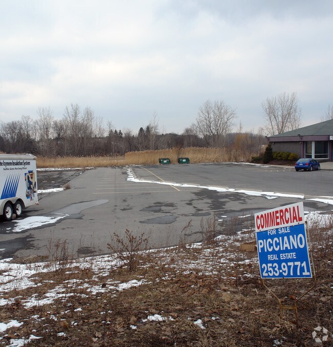
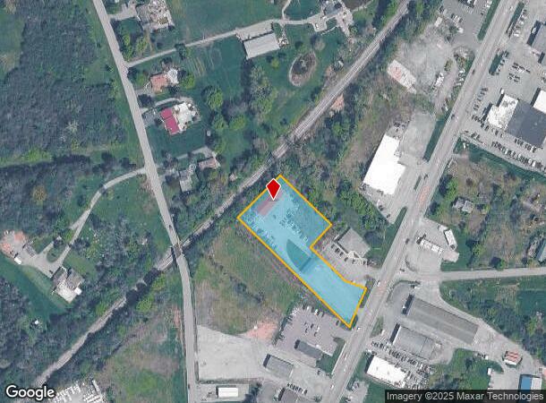
Property Record
331 State St, Auburn, NY 13021
NEARBY LISTINGS FOR SALE OR LEASE
Property Detail
331 State St
055200-109-002-0001-052-000-0000
SM BB-51,92-99,92-127,L-B UNR SM,FORM 109-1-17.1 APPR 921-115;AD 889-350
Storesoffices
Cayuga
X
New York
36011C0308E
52.000
2025
1.67 AC
2024
Syracuse Surrounding
041300
Other Market Areas
1,320 SF
Auburn, NY
DEMOGRAPHICS near 331 State St
1 Mile
3 Mile
5 Mile
2024 Total Population
933
25,126
37,066
2029 Population
903
24,796
36,576
Pop Growth 2024-2029
(3.22%)
(1.31%)
(1.32%)
Average Age
45
42
43
2024 Total Households
417
10,849
15,900
HH Growth 2024-2029
(3.60%)
(1.45%)
(1.46%)
Median Household Inc
$42,802
$53,153
$57,679
Avg Household Size
2.00
2.10
2.20
2024 Avg HH Vehicles
1.00
1.00
2.00
Median Home Value
$166,291
$153,225
$162,937
Median Year Built
1960
1948
1951
Nearby Places
Map Layers
Map Styles
 Street
 Aerial
- Restaurants
- Banks
- Shops
- Fitness
- Groceries
PUBLIC TRANSPORTATION
AIRPORT
Syracuse Hancock International
DRIVE
WALK
Distance
Syracuse Hancock International
41 min
30.4 mi
Freight Ports
Albany, NY Port
DRIVE
WALK
Distance
Albany, NY Port
205 min
169.8 mi
Nearby Properties
Address
Land Use
TOTAL SIZE
Lot Size
Zoning
Address
Land Use
TOTAL SIZE
Lot Size
Zoning
6,085 SF
23 AC
CC
Address
Land Use
TOTAL SIZE
Lot Size
Zoning
2,496 SF
15.27 AC
R1
Address
Land Use
TOTAL SIZE
Lot Size
Zoning
225,619 SF
6.90 AC
C
Address
Land Use
TOTAL SIZE
Lot Size
Zoning
3,360 SF
29.33 AC
I1
Address
Land Use
TOTAL SIZE
Lot Size
Zoning
165,775 SF
39.40 AC
R1
Address
Land Use
TOTAL SIZE
Lot Size
Zoning
190,229 SF
29.04 AC
HC
Address
Land Use
TOTAL SIZE
Lot Size
Zoning
330,772 SF
27.80 AC
I
Address
Land Use
TOTAL SIZE
Lot Size
Zoning
444,450 SF
30.70 AC
I1
Address
Land Use
TOTAL SIZE
Lot Size
Zoning
201,003 SF
16.44 AC
HC
Address
Land Use
TOTAL SIZE
Lot Size
Zoning
1,966 SF
20 AC
R2
Address
Land Use
TOTAL SIZE
Lot Size
Zoning
113,388 SF
12.15 AC
R1
Address
Land Use
TOTAL SIZE
Lot Size
Zoning
88,967 SF
1.62 AC
D
Address
Land Use
TOTAL SIZE
Lot Size
Zoning
449,222 SF
191.49 AC
I
Address
Land Use
TOTAL SIZE
Lot Size
Zoning
72,267 SF
2.75 AC
D
Address
Land Use
TOTAL SIZE
Lot Size
Zoning
117,877 SF
5.08 AC
D
Address
Land Use
TOTAL SIZE
Lot Size
Zoning
120,933 SF
1.47 AC
D
Address
Land Use
TOTAL SIZE
Lot Size
Zoning
35,518 SF
30.50 AC
AR
Address
Land Use
TOTAL SIZE
Lot Size
Zoning
109,990 SF
37.46 AC
R1
Address
Land Use
TOTAL SIZE
Lot Size
Zoning
205,125 SF
18.80 AC
CL
Address
Land Use
TOTAL SIZE
Lot Size
Zoning
1,015 SF
1.20 AC
C
Address
Land Use
TOTAL SIZE
Lot Size
Zoning
101,680 SF
4.40 AC
D
Address
Land Use
TOTAL SIZE
Lot Size
Zoning
18,000 SF
2.20 AC
D
Address
Land Use
TOTAL SIZE
Lot Size
Zoning
68,160 SF
7.25 AC
CL
Address
Land Use
TOTAL SIZE
Lot Size
Zoning
3,561 SF
9.03 AC
R2
Address
Land Use
TOTAL SIZE
Lot Size
Zoning
4,050 SF
94.50 AC
I2
Address
Land Use
TOTAL SIZE
Lot Size
Zoning
85,584 SF
1.97 AC
D
Address
Land Use
TOTAL SIZE
Lot Size
Zoning
6,670 SF
0.97 AC
D
Address
Land Use
TOTAL SIZE
Lot Size
Zoning
45.70 AC
AR
Address
Land Use
TOTAL SIZE
Lot Size
Zoning
70,425 SF
4.32 AC
D
Address
Land Use
TOTAL SIZE
Lot Size
Zoning
128,604 SF
1.37 AC
D
The World's #1 Commercial Real Estate Marketplace
Connect with us
© 2025 CoStar Group
The information above has been obtained from sources believed reliable. While we do not doubt its accuracy we have not verified it and make no guarantee, warranty or representation about it. It is your responsibility to independently confirm its accuracy and completeness. Any projections, opinions, assumptions, or estimates used are for example only and do not represent the current or future performance of the property. The value of this transaction to you depends on tax and other factors which should be evaluated by your tax, financial, and legal advisors. You and your advisors should conduct a careful, independent investigation of the property to determine to your satisfaction the suitability of the property for your needs.