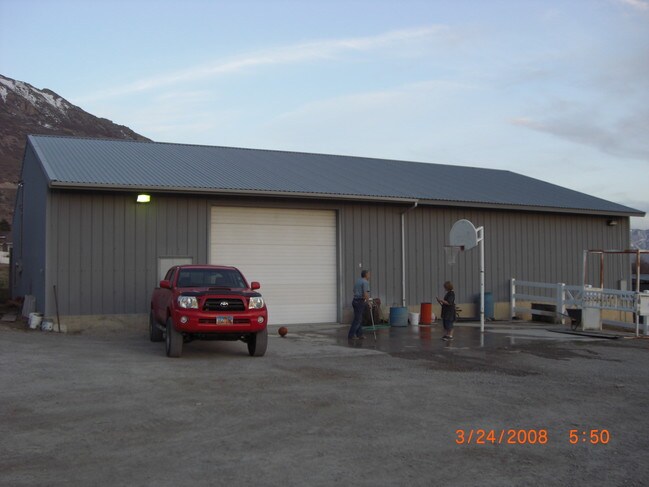
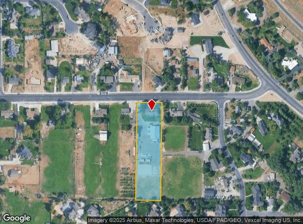
Property Record
331 W 2600 N, Pleasant Grove, UT 84062
NEARBY LISTINGS FOR SALE OR LEASE
Property Detail
331 W 2600 N
Provo-Orem, UT
COM S 32 FT & W 253.1 FT FR N 1/4 COR. SEC. 17, T5S, R2E, SLB&M.; S 0 DEG 57 0 W 585.56 FT; N 89 DEG 8 20 W 149.98 FT; N 0 DEG 57 0 E 583.3 FT; E 150 FT TO BEG. AREA 2.012 AC.
14-014-0057
Utah
Commercialnec
Utah
2024
2.01 AC
2025
Utah County
010226
Salt Lake City
1,530 SF
DEMOGRAPHICS near 331 W 2600 N
1 Mile
3 Mile
5 Mile
2024 Total Population
8,745
75,503
141,440
2029 Population
10,200
88,196
164,879
Pop Growth 2024-2029
+ 16.64%
+ 16.81%
+ 16.57%
Average Age
34
33
33
2024 Total Households
2,153
22,078
39,747
HH Growth 2024-2029
+ 17.05%
+ 17.26%
+ 17.01%
Median Household Inc
$144,764
$91,808
$100,812
Avg Household Size
4.00
3.40
3.50
2024 Avg HH Vehicles
3.00
2.00
3.00
Median Home Value
$632,256
$468,244
$509,849
Median Year Built
2002
2000
1999
Nearby Places
Map Layers
Map Styles
 Street
 Aerial
- Restaurants
- Banks
- Shops
- Fitness
- Groceries
PUBLIC TRANSPORTATION
COMMUTER RAIL
American Fork Station (FrontRunner - Utah Transit Authority (UTA))
DRIVE
WALK
Distance
American Fork Station (FrontRunner - Utah Transit Authority (UTA))
13 min
5.7 mi
Vineyard Station (FrontRunner - Utah Transit Authority (UTA))
DRIVE
WALK
Distance
Vineyard Station (FrontRunner - Utah Transit Authority (UTA))
12 min
6.7 mi
AIRPORT
Provo Municipal
DRIVE
WALK
Distance
Provo Municipal
24 min
15.4 mi
Salt Lake City International
DRIVE
WALK
Distance
Salt Lake City International
51 min
39.4 mi
Freight Ports
Port of Stockton
DRIVE
WALK
Distance
Port of Stockton
751 min
729.8 mi
Nearby Properties
Address
Land Use
TOTAL SIZE
Lot Size
Zoning
Address
Land Use
TOTAL SIZE
Lot Size
Zoning
587,192 SF
48.27 AC
Address
Land Use
TOTAL SIZE
Lot Size
Zoning
400,684 SF
10.39 AC
Address
Land Use
TOTAL SIZE
Lot Size
Zoning
322,826 SF
9.53 AC
Address
Land Use
TOTAL SIZE
Lot Size
Zoning
21,510 SF
6.66 AC
Address
Land Use
TOTAL SIZE
Lot Size
Zoning
230,702 SF
11.85 AC
Address
Land Use
TOTAL SIZE
Lot Size
Zoning
171,905 SF
6.62 AC
Address
Land Use
TOTAL SIZE
Lot Size
Zoning
327,092 SF
14.61 AC
Address
Land Use
TOTAL SIZE
Lot Size
Zoning
333,724 SF
13.12 AC
Address
Land Use
TOTAL SIZE
Lot Size
Zoning
268,989 SF
12.78 AC
Address
Land Use
TOTAL SIZE
Lot Size
Zoning
8.99 AC
Address
Land Use
TOTAL SIZE
Lot Size
Zoning
154,800 SF
9.14 AC
Address
Land Use
TOTAL SIZE
Lot Size
Zoning
269,768 SF
14.94 AC
Address
Land Use
TOTAL SIZE
Lot Size
Zoning
194,852 SF
10.03 AC
Address
Land Use
TOTAL SIZE
Lot Size
Zoning
182,338 SF
7.97 AC
Address
Land Use
TOTAL SIZE
Lot Size
Zoning
153,790 SF
12.07 AC
Address
Land Use
TOTAL SIZE
Lot Size
Zoning
200,016 SF
8.82 AC
Address
Land Use
TOTAL SIZE
Lot Size
Zoning
409,362 SF
29.53 AC
Address
Land Use
TOTAL SIZE
Lot Size
Zoning
94,851 SF
6.10 AC
Address
Land Use
TOTAL SIZE
Lot Size
Zoning
109,875 SF
5.43 AC
Address
Land Use
TOTAL SIZE
Lot Size
Zoning
176,113 SF
11.33 AC
Address
Land Use
TOTAL SIZE
Lot Size
Zoning
134,728 SF
13.07 AC
Address
Land Use
TOTAL SIZE
Lot Size
Zoning
180,844 SF
5.80 AC
Address
Land Use
TOTAL SIZE
Lot Size
Zoning
70,213 SF
2.14 AC
Address
Land Use
TOTAL SIZE
Lot Size
Zoning
177,801 SF
7.82 AC
Address
Land Use
TOTAL SIZE
Lot Size
Zoning
39,947 SF
10.21 AC
Address
Land Use
TOTAL SIZE
Lot Size
Zoning
105,223 SF
12.48 AC
Address
Land Use
TOTAL SIZE
Lot Size
Zoning
83,819 SF
4.84 AC
Address
Land Use
TOTAL SIZE
Lot Size
Zoning
157,950 SF
6.53 AC
Address
Land Use
TOTAL SIZE
Lot Size
Zoning
28,882 SF
12.75 AC
The World's #1 Commercial Real Estate Marketplace
Connect with us
© 2025 CoStar Group
The information above has been obtained from sources believed reliable. While we do not doubt its accuracy we have not verified it and make no guarantee, warranty or representation about it. It is your responsibility to independently confirm its accuracy and completeness. Any projections, opinions, assumptions, or estimates used are for example only and do not represent the current or future performance of the property. The value of this transaction to you depends on tax and other factors which should be evaluated by your tax, financial, and legal advisors. You and your advisors should conduct a careful, independent investigation of the property to determine to your satisfaction the suitability of the property for your needs.