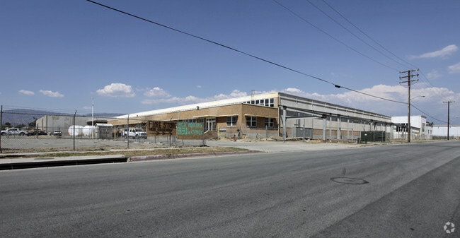
Property Record
331 W Citrus St, Colton, CA 92324


NEARBY LISTINGS FOR SALE OR LEASE
Property Detail
331 W Citrus St
Riverside-San Bernardino-Ontario, CA
Colton Land & Water Co
0160-141-34
PARCEL MAP 19324 PARCEL 1 BOOK 244 PAGE 32
Foodprocessing
San Bernardino
X
California
06071C8679J
7
2025
16.45 AC
2025
San Bernardino
006700
Inland Empire (California)
306,556 SF
DEMOGRAPHICS near 331 W Citrus St
1 mile
3 mile
5 mile
2024 Total Population
22,597
133,534
348,330
2029 Population
22,823
135,392
353,962
Pop Growth 2024-2029
+ 1.00%
+ 1.39%
+ 1.62%
Average Age
35
35
35
2024 Total Households
6,074
37,019
97,396
HH Growth 2024-2029
+ 1.00%
+ 1.49%
+ 1.70%
Median Household Inc
$56,920
$57,226
$61,651
Avg Household Size
3.60
3.50
3.50
2024 Avg HH Vehicles
2.00
2.00
2.00
Median Home Value
$337,112
$332,978
$355,048
Median Year Built
1962
1971
1972
Nearby Places
Map Layers
Map Styles
 Street
 Aerial
Transit
 Traffic
 Biking
Places
Listings with unknown addresses are not visible on the map
- Restaurants
- Banks
- Shops
- Fitness
- Groceries
PUBLIC TRANSPORTATION
COMMUTER RAIL
San Bernardino (Inland Empire-Orange County Line - Southern California Regional Rail Authority (Metrolink), San Bernardino Line - Southern California Regional Rail Authority (Metrolink))
Drive
Walk
Distance
San Bernardino (Inland Empire-Orange County Line - Southern California Regional Rail Authority (Metrolink), San Bernardino Line - Southern California Regional Rail Authority (Metrolink))
6 min
2.7 mi
San Bernardino - Downtown Metrolink Station (Metrolink Inland Empire-Orange County Line - Metrolink Trains, Metrolink San Bernardino Line - Metrolink Trains)
Drive
Walk
Distance
San Bernardino - Downtown Metrolink Station (Metrolink Inland Empire-Orange County Line - Metrolink Trains, Metrolink San Bernardino Line - Metrolink Trains)
9 min
3.6 mi
AIRPORT
Ontario International
Drive
Walk
Distance
Ontario International
26 min
18.3 mi
Freight Ports
Port of Long Beach
Drive
Walk
Distance
Port of Long Beach
86 min
65.1 mi
Nearby Properties
Address
Land Use
TOTAL SIZE
Lot Size
Zoning
Address
Land Use
TOTAL SIZE
Lot Size
Zoning
457,253 SF
20.14 AC
Address
Land Use
TOTAL SIZE
Lot Size
Zoning
308,030 SF
16.20 AC
Address
Land Use
TOTAL SIZE
Lot Size
Zoning
1,032,072 SF
61.74 AC
Address
Land Use
TOTAL SIZE
Lot Size
Zoning
330,420 SF
15.31 AC
Address
Land Use
TOTAL SIZE
Lot Size
Zoning
340,120 SF
36.36 AC
Address
Land Use
TOTAL SIZE
Lot Size
Zoning
1,081,199 SF
49.77 AC
Address
Land Use
TOTAL SIZE
Lot Size
Zoning
300,188 SF
11.98 AC
Address
Land Use
TOTAL SIZE
Lot Size
Zoning
758,180 SF
31.86 AC
Address
Land Use
TOTAL SIZE
Lot Size
Zoning
391,468 SF
16.73 AC
Address
Land Use
TOTAL SIZE
Lot Size
Zoning
206,244 SF
15.22 AC
Address
Land Use
TOTAL SIZE
Lot Size
Zoning
210,418 SF
12.09 AC
Address
Land Use
TOTAL SIZE
Lot Size
Zoning
225,324 SF
11.03 AC
Address
Land Use
TOTAL SIZE
Lot Size
Zoning
851,880 SF
42.20 AC
Address
Land Use
TOTAL SIZE
Lot Size
Zoning
549,796 SF
13.61 AC
Address
Land Use
TOTAL SIZE
Lot Size
Zoning
151,859 SF
7.23 AC
Address
Land Use
TOTAL SIZE
Lot Size
Zoning
592,710 SF
28.89 AC
Address
Land Use
TOTAL SIZE
Lot Size
Zoning
318,940 SF
14.26 AC
Address
Land Use
TOTAL SIZE
Lot Size
Zoning
154,639 SF
6.87 AC
Address
Land Use
TOTAL SIZE
Lot Size
Zoning
16,000 SF
11.17 AC
Address
Land Use
TOTAL SIZE
Lot Size
Zoning
190,949 SF
7.68 AC
Address
Land Use
TOTAL SIZE
Lot Size
Zoning
413,953 SF
19.58 AC
Address
Land Use
TOTAL SIZE
Lot Size
Zoning
153,093 SF
2.69 AC
Address
Land Use
TOTAL SIZE
Lot Size
Zoning
149,760 SF
6.01 AC
Address
Land Use
TOTAL SIZE
Lot Size
Zoning
345,237 SF
14.52 AC
Address
Land Use
TOTAL SIZE
Lot Size
Zoning
166,376 SF
18.75 AC
Address
Land Use
TOTAL SIZE
Lot Size
Zoning
198,818 SF
8.94 AC
Address
Land Use
TOTAL SIZE
Lot Size
Zoning
179,550 SF
8.04 AC
Address
Land Use
TOTAL SIZE
Lot Size
Zoning
457,216 SF
23.30 AC
Address
Land Use
TOTAL SIZE
Lot Size
Zoning
190,704 SF
6.39 AC
Address
Land Use
TOTAL SIZE
Lot Size
Zoning
193,970 SF
18.99 AC
The World's #1 Commercial Real Estate Marketplace
Connect with us
© 2026 CoStar Group
The information above has been obtained from sources believed reliable. While we do not doubt its accuracy we have not verified it and make no guarantee, warranty or representation about it. It is your responsibility to independently confirm its accuracy and completeness. Any projections, opinions, assumptions, or estimates used are for example only and do not represent the current or future performance of the property. The value of this transaction to you depends on tax and other factors which should be evaluated by your tax, financial, and legal advisors. You and your advisors should conduct a careful, independent investigation of the property to determine to your satisfaction the suitability of the property for your needs.